TopoQuest Logo
Do you find TopoQuest useful?
Help keep TopoQuest running and adding new maps/features by donating!
Bitcoin:  19c7KJd3qBynnjoSw5npx9KScwjBe4ifkT
Litecoin:  LXs6TkuXGGXo1vDsWCkWVdjQX94eUKd6ui
Home View Maps Find Maps Find Places Resources & Links


Bull Run Lake, Oregon Topographic Map

USGS Map Title: Bull Run Lake, OR
USGS Map MRC: 45121D7
DRG (GeoTIFF) Download: o45121d7.tif


Neighboring USGS Topographic Map Quads:


  Tanner Butte, OR  
45121E8
 

  Wahtum Lake, OR  
45121E7
 

  Dee, OR  
45121E6
 

  Hickman Butte, OR  
45121D8
 

  Bull Run Lake, OR  
45121D7
 

  Mount Hood North, OR  
45121D6
 

  Rhododendron, OR  
45121C8
 

  Government Camp, OR  
45121C7
 

  Mount Hood South, OR  
45121C6


Map MRC Location:

N46°
W122°
N46°
W121°
H8 H7 H6 H5 H4 H3 H2 H1
G8 G7 G6 G5 G4 G3 G2 G1
F8 F7 F6 F5 F4 F3 F2 F1
E8 E7 E6 E5 E4 E3 E2 E1
D8 D7 D6 D5 D4 D3 D2 D1
C8 C7 C6 C5 C4 C3 C2 C1
B8 B7 B6 B5 B4 B3 B2 B1
A8 A7 A6 A5 A4 A3 A2 A1
N45°
W122°
N45°
W121°

Bull Run Lake, OR USGS 1:24K Topographic Map Preview:
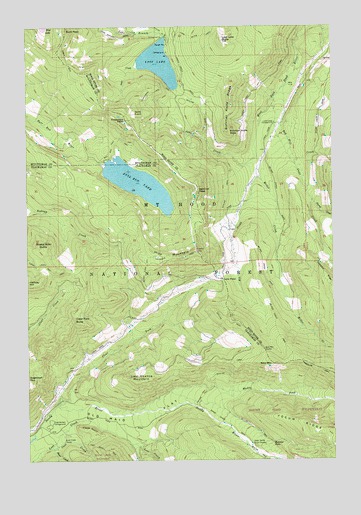
Bull Run Lake, OR USGS Topographic Map
Click on map above to begin viewing in our Map Viewer.

This topographic map contains these locations and features:
Feature Name Type Latitude Longitude GNIS ID View Map
Bald MountainSummitN45.4023°W121.7756°1137455View Map
Bald Mountain RidgeRidgeN45.4007°W121.7542°1158611View Map
Bald Mountain ShelterLocaleN45.4068°W121.7795°1137459View Map
Blazed Alder ButteSummitN45.4360°W121.8695°1138256View Map
Blazed Alder Way TrailTrailN45.4387°W121.8287°1138258View Map
Blue LakeLakeN45.4999°W121.8690°1138315View Map
Buck PeakSummitN45.4987°W121.8598°1138810View Map
Bull Run LakeLakeN45.4547°W121.8303°1154282View Map
Bull Run Lake DamDamN45.4560°W121.8304°1155533View Map
Bull Run Lake TrailTrailN45.4676°W121.8395°1138918View Map
Bull Run Research Natural AreaParkN45.4468°W121.8131°1156343View Map
Butcher Knife RidgeRidgeN45.4768°W121.7923°1139038View Map
Butcher PeakSummitN45.4696°W121.7934°1139040View Map
Cape HornSummitN45.3837°W121.8512°1139347View Map
Cast CreekStreamN45.3782°W121.8670°1139436View Map
Chitwood QuarryMineN45.4664°W121.8661°2754366View Map
Chitwood TrailTrailN45.4335°W121.8170°1139708View Map
Clear ForkStreamN45.3907°W121.8642°1139798View Map
Clear Fork ButteSummitN45.4154°W121.8565°1139799View Map
Devils PulpitSummitN45.4750°W121.8325°1140970View Map
Dodge IslandIslandN45.4607°W121.8398°1154290View Map
Elk CreekStreamN45.4568°W121.7815°1141749View Map
Hiyu MountainSummitN45.4351°W121.8065°1143621View Map
Hiyu Mountain QuarryMineN45.4335°W121.8291°2754367View Map
Huckleberry Mountain TrailTrailN45.4812°W121.8240°1143885View Map
Inlet CreekStreamN45.4882°W121.8304°1144099View Map
Jones CreekStreamN45.4621°W121.7817°1144380View Map
Ladd CreekStreamN45.4790°W121.7748°1144734View Map
Ladd Creek CampgroundLocaleN45.4721°W121.7745°1144735View Map
Last Chance MountainSummitN45.3973°W121.8317°1144847View Map
Lolo PassGapN45.4268°W121.7959°1145348View Map
Lost Creek Recreation SiteLocaleN45.3815°W121.8359°1155882View Map
Lost LakeLakeN45.4893°W121.8217°1145546View Map
Lost Lake Boat RampLocaleN45.4957°W121.8223°2700123View Map
Lost Lake ButteSummitN45.4962°W121.7959°1145547View Map
Lost Lake Butte TrailTrailN45.4971°W121.8048°1145548View Map
Lost Lake Ranger StationBuildingN45.4951°W121.8190°1153242View Map
Lost Lake Recreation SiteLocaleN45.4962°W121.8187°1159332View Map
Lost Lake ResortPopulated PlaceN45.4976°W121.8187°1167210View Map
McGee CreekStreamN45.4621°W121.7817°1145980View Map
McNeil Recreation SiteLocaleN45.3854°W121.8667°1142432View Map
Muddy ForkStreamN45.3946°W121.8179°1146615View Map
Old Maid FlatFlatN45.3871°W121.8329°1147199View Map
Portage TrailTrailN45.3932°W121.8048°1147906View Map
Preachers PeakSummitN45.4729°W121.8351°1147993View Map
Ramona FallsFallsN45.3800°W121.7760°1148191View Map
Red Hill CreekStreamN45.4832°W121.7695°1148307View Map
Riley Horse CampLocaleN45.3810°W121.8609°1145528View Map
Rushing Water CreekStreamN45.3757°W121.7798°1148853View Map
Salvation SpringSpringN45.4700°W121.8300°2125495View Map
Sandy River TrailTrailN45.3851°W121.7934°1149059View Map
Sentinel PeakSummitN45.4537°W121.8062°1149235View Map
Short CreekStreamN45.3785°W121.8648°1149434View Map
Stump CreekStreamN45.4498°W121.7595°1150505View Map
Table Mountain TrailTrailN45.4857°W121.8573°1150820View Map
Upper Sandy Guard StationLocaleN45.3793°W121.7837°1151702View Map

Note: Coordinates in the location and feature list above are referenced to NAD83 datum.


Copyright (C) 2008-2024 Ryan Niemi / Sunset Dynamics ... All Rights Reserved