TopoQuest Logo
Do you find TopoQuest useful?
Help keep TopoQuest running and adding new maps/features by donating!
Bitcoin:  19c7KJd3qBynnjoSw5npx9KScwjBe4ifkT
Litecoin:  LXs6TkuXGGXo1vDsWCkWVdjQX94eUKd6ui
Home View Maps Find Maps Find Places Resources & Links


Bull Island, Montana Topographic Map

USGS Map Title: Bull Island, MT
USGS Map MRC: 47114G1
DRG (GeoTIFF) Download: o47114g1.tif


Neighboring USGS Topographic Map Quads:


  Rollins, MT  
47114H2
 

  Woods Bay, MT  
47114H1
 

  Yew Creek, MT  
47113H8
 

  Wild Horse Island, MT  
47114G2
 

  Bull Island, MT  
47114G1
 

  Porcupine Creek, MT  
47113G8
 

  Polson, MT  
47114F2
 

  East Bay, MT  
47114F1
 

  Cedar Lake, MT  
47113F8


Map MRC Location:

N48°
W115°
N48°
W114°
H8 H7 H6 H5 H4 H3 H2 H1
G8 G7 G6 G5 G4 G3 G2 G1
F8 F7 F6 F5 F4 F3 F2 F1
E8 E7 E6 E5 E4 E3 E2 E1
D8 D7 D6 D5 D4 D3 D2 D1
C8 C7 C6 C5 C4 C3 C2 C1
B8 B7 B6 B5 B4 B3 B2 B1
A8 A7 A6 A5 A4 A3 A2 A1
N47°
W115°
N47°
W114°

Bull Island, MT USGS 1:24K Topographic Map Preview:
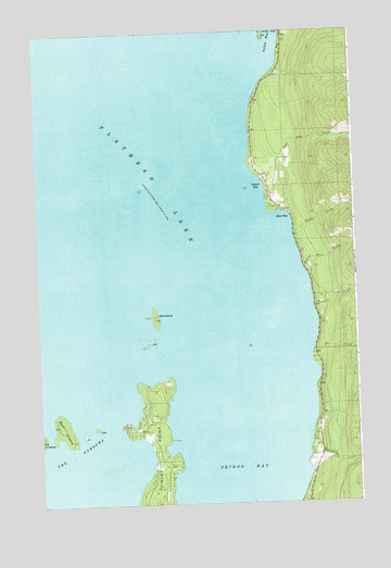
Bull Island, MT USGS Topographic Map
Click on map above to begin viewing in our Map Viewer.

This topographic map contains these locations and features:
Feature Name Type Latitude Longitude GNIS ID View Map
23N19W07BAAA01 WellWellN47.7766°W114.0823°824921View Map
23N19W07BDAC01 WellWellN47.7713°W114.0840°824903View Map
23N19W18ABB_01 WellWellN47.7605°W114.0798°824866View Map
23N19W18BDAC01 WellWellN47.7561°W114.0834°824836View Map
24N19W16DCA_01 WellWellN47.8366°W114.0343°825072View Map
24N19W21ACAA01 WellWellN47.8297°W114.0329°825047View Map
Bird IslandIslandN47.7997°W114.0793°768882View Map
Blue BayBayN47.8249°W114.0290°769036View Map
Blue Bay (historical)LocaleN47.8277°W114.0273°1796929View Map
Blue Bay CreekStreamN47.8274°W114.0276°780136View Map
Boulder CreekStreamN47.8022°W114.0171°780263View Map
Bull IslandIslandN47.7705°W114.1162°769375View Map
Dee CreekStreamN47.7897°W114.0182°782188View Map
Finley PointCapeN47.7633°W114.0796°771355View Map
Finley Point (historical)LocaleN47.7666°W114.0787°1796915View Map
Finley Point CampgroundLocaleN47.7638°W114.0787°1797010View Map
Flathead Lake State Park - Finley Point UnitParkN47.7638°W114.0787°1796799View Map
Skidoo BayBayN47.7602°W114.0451°776609View Map
Station CreekStreamN47.7624°W114.0198°791467View Map
Sunset BayBayN47.8336°W114.0404°777331View Map
Talking Water CreekStreamN47.8122°W114.0209°791865View Map
Teepee CreekStreamN47.8208°W114.0246°791937View Map
The NarrowsChannelN47.7636°W114.1132°777520View Map
Yellow BayBayN47.8736°W114.0309°793600View Map

Note: Coordinates in the location and feature list above are referenced to NAD83 datum.


Copyright (C) 2008-2024 Ryan Niemi / Sunset Dynamics ... All Rights Reserved