TopoQuest Logo
Do you find TopoQuest useful?
Help keep TopoQuest running and adding new maps/features by donating!
Bitcoin:  19c7KJd3qBynnjoSw5npx9KScwjBe4ifkT
Litecoin:  LXs6TkuXGGXo1vDsWCkWVdjQX94eUKd6ui
Home View Maps Find Maps Find Places Resources & Links


Buffalo Knob, Texas Topographic Map

USGS Map Title: Buffalo Knob, TX
USGS Map MRC: 31098A7
DRG (GeoTIFF) Download: o31098a7.tif


Neighboring USGS Topographic Map Quads:


  Baker Spring, TX  
31098B8
 

  Algerita, TX  
31098B7
 

  San Saba, TX  
31098B6
 

  Brady Mountain, TX  
31098A8
 

  Buffalo Knob, TX  
31098A7
 

  Bear Hollow, TX  
31098A6
 

  Pontotoc, TX  
30098H8
 

  Magill Mountain, TX  
30098H7
 

  Cherokee, TX  
30098H6


Map MRC Location:

N32°
W99°
N32°
W98°
H8 H7 H6 H5 H4 H3 H2 H1
G8 G7 G6 G5 G4 G3 G2 G1
F8 F7 F6 F5 F4 F3 F2 F1
E8 E7 E6 E5 E4 E3 E2 E1
D8 D7 D6 D5 D4 D3 D2 D1
C8 C7 C6 C5 C4 C3 C2 C1
B8 B7 B6 B5 B4 B3 B2 B1
A8 A7 A6 A5 A4 A3 A2 A1
N31°
W99°
N31°
W98°

Buffalo Knob, TX USGS 1:24K Topographic Map Preview:
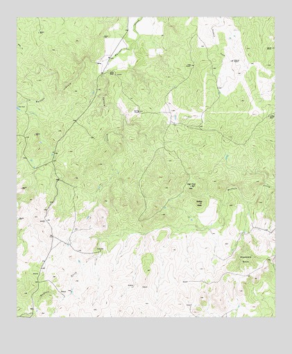
Buffalo Knob, TX USGS Topographic Map
Click on map above to begin viewing in our Map Viewer.

This topographic map contains these locations and features:
Feature Name Type Latitude Longitude GNIS ID View Map
Behmes WindmillLocaleN31.1121°W98.7520°1351803View Map
Buffalo KnobSummitN31.0477°W98.7875°1353203View Map
Bull Trap WindmillLocaleN31.0857°W98.8162°1353266View Map
Dofflemyer WindmillLocaleN31.1068°W98.7706°1356113View Map
Flying V WindmillLocaleN31.0838°W98.7531°1357518View Map
High Pond MountainSummitN31.0546°W98.7912°1359188View Map
Kelley WindmillLocaleN31.1052°W98.7912°1360531View Map
Latham CreekStreamN31.1082°W98.8292°1360975View Map
Nored RanchLocaleN31.1021°W98.8306°1363962View Map
San Saba County Historical MuseumBuildingN31.0699°W98.8037°2014441View Map
San Saba DivisionCivilN31.0683°W98.7936°1939171View Map
Soil Conservation Service Site 13a DamDamN31.0935°W98.8353°1863322View Map
Soil Conservation Service Site 13a ReservoirReservoirN31.0935°W98.8353°1863323View Map
Soil Conservation Service Site 14a DamDamN31.1035°W98.8637°1854891View Map
Soil Conservation Service Site 14a ReservoirReservoirN31.1035°W98.8637°1854892View Map
Wallace SpringsSpringN31.1085°W98.8587°1998382View Map
Woodward GroveWoodsN31.0243°W98.7642°1371939View Map

Note: Coordinates in the location and feature list above are referenced to NAD83 datum.


Copyright (C) 2008-2024 Ryan Niemi / Sunset Dynamics ... All Rights Reserved