TopoQuest Logo
Do you find TopoQuest useful?
Help keep TopoQuest running and adding new maps/features by donating!
Bitcoin:  19c7KJd3qBynnjoSw5npx9KScwjBe4ifkT
Litecoin:  LXs6TkuXGGXo1vDsWCkWVdjQX94eUKd6ui
Home View Maps Find Maps Find Places Resources & Links


Buckhorn Mountain, Texas Topographic Map

USGS Map Title: Buckhorn Mountain, TX
USGS Map MRC: 30104H1
DRG (GeoTIFF) Download: o30104h1.tif


Neighboring USGS Topographic Map Quads:


  Kent, TX  
31104A2
 

  Gomez Peak, TX  
31104A1
 

  Sotol Hill, TX  
31103A8
 

  Echo Canyon, TX  
30104H2
 

  Buckhorn Mountain, TX  
30104H1
 

  Antelope Flat, TX  
30103H8
 

  Robbers Roost Canyon, TX  
30104G2
 

  Friend Mountain, TX  
30104G1
 

  Little Aguja Mountain, TX  
30103G8


Map MRC Location:

N31°
W105°
N31°
W104°
H8 H7 H6 H5 H4 H3 H2 H1
G8 G7 G6 G5 G4 G3 G2 G1
F8 F7 F6 F5 F4 F3 F2 F1
E8 E7 E6 E5 E4 E3 E2 E1
D8 D7 D6 D5 D4 D3 D2 D1
C8 C7 C6 C5 C4 C3 C2 C1
B8 B7 B6 B5 B4 B3 B2 B1
A8 A7 A6 A5 A4 A3 A2 A1
N30°
W105°
N30°
W104°

Buckhorn Mountain, TX USGS 1:24K Topographic Map Preview:
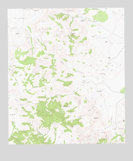
Buckhorn Mountain, TX USGS Topographic Map
Click on map above to begin viewing in our Map Viewer.

This topographic map contains these locations and features:
Feature Name Type Latitude Longitude GNIS ID View Map
Bear Wallow SpringSpringN30.8956°W104.0025°1351700View Map
Buckhorn CanyonValleyN30.9157°W104.0248°1353154View Map
Buckhorn MountainSummitN30.8985°W104.0344°1353163View Map
Cherry CanyonValleyN30.9218°W104.0034°1373069View Map
Cherry Canyon RanchLocaleN30.8882°W104.0105°1354351View Map
Dipping Vat SpringSpringN30.9884°W104.0466°1356042View Map
Falls CanyonValleyN30.9872°W104.0325°1357208View Map
Falls SpringSpringN30.9876°W104.0332°1357217View Map
Fox CanyonValleyN30.9307°W104.0505°1357660View Map
Gomez WindmillLocaleN30.9768°W104.1138°1358142View Map
Hell CanyonValleyN30.9241°W104.0531°1359007View Map
Indian PeakSummitN30.8910°W104.0585°1359974View Map
K C RanchLocaleN30.9493°W104.0182°1360477View Map
Left Hand Falls CanyonValleyN30.9919°W104.0535°1361054View Map
Leonard Camp WindmillLocaleN30.9763°W104.0571°1361101View Map
Moody CanyonValleyN30.9740°W104.0965°1363078View Map
Mount McElroySummitN30.9093°W104.0632°1362441View Map
Mud SpringSpringN30.8964°W104.0595°1363417View Map
Oak SpringSpringN30.9981°W104.0960°1364300View Map
Onion SpringSpringN30.9911°W104.1075°1364562View Map
Orchard SpringSpringN30.9390°W104.0215°1364579View Map
Prizer DrawValleyN30.9338°W104.0409°1375571View Map
Right Hand Falls CanyonValleyN30.9917°W104.0540°1366464View Map
Shelbarger SpringSpringN30.9232°W104.0291°1368103View Map
Sierra WindmillLocaleN30.9688°W104.0188°1368260View Map
Solomon CanyonValleyN30.9338°W104.0408°1368600View Map
Willow SpringSpringN30.9540°W104.0180°1371669View Map
Wood Canyon WellWellN30.9024°W104.1221°1371887View Map
Zero Three RanchLocaleN30.9326°W104.0435°1372087View Map

Note: Coordinates in the location and feature list above are referenced to NAD83 datum.


Copyright (C) 2008-2024 Ryan Niemi / Sunset Dynamics ... All Rights Reserved