TopoQuest Logo
Do you find TopoQuest useful?
Help keep TopoQuest running and adding new maps/features by donating!
Bitcoin:  19c7KJd3qBynnjoSw5npx9KScwjBe4ifkT
Litecoin:  LXs6TkuXGGXo1vDsWCkWVdjQX94eUKd6ui
Home View Maps Find Maps Find Places Resources & Links


Bryce Canyon, Utah Topographic Map

USGS Map Title: Bryce Canyon, UT
USGS Map MRC: 37112F2
DRG (GeoTIFF) Download: o37112f2.tif


Neighboring USGS Topographic Map Quads:


  Casto Canyon, UT  
37112G3
 

  Flake Mountain West, UT  
37112G2
 

  Flake Mountain East, UT  
37112G1
 

  Wilson Peak, UT  
37112F3
 

  Bryce Canyon, UT  
37112F2
 

  Tropic Canyon, UT  
37112F1
 

  Tropic Reservoir, UT  
37112E3
 

  Bryce Point, UT  
37112E2
 

  Cannonville, UT  
37112E1


Map MRC Location:

N38°
W113°
N38°
W112°
H8 H7 H6 H5 H4 H3 H2 H1
G8 G7 G6 G5 G4 G3 G2 G1
F8 F7 F6 F5 F4 F3 F2 F1
E8 E7 E6 E5 E4 E3 E2 E1
D8 D7 D6 D5 D4 D3 D2 D1
C8 C7 C6 C5 C4 C3 C2 C1
B8 B7 B6 B5 B4 B3 B2 B1
A8 A7 A6 A5 A4 A3 A2 A1
N37°
W113°
N37°
W112°

Bryce Canyon, UT USGS 1:24K Topographic Map Preview:
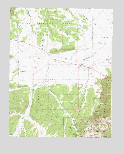
Bryce Canyon, UT USGS Topographic Map
Click on map above to begin viewing in our Map Viewer.

This topographic map contains these locations and features:
Feature Name Type Latitude Longitude GNIS ID View Map
Ahlstrom HollowValleyN37.6729°W112.2209°1438138View Map
Berry Spring CreekStreamN37.7230°W112.2185°1438613View Map
Blue Fly CreekStreamN37.6453°W112.2327°1438930View Map
Boat MesaSummitN37.6420°W112.1456°1438979View Map
Bryce AmphitheaterAreaN37.6264°W112.1507°1448196View Map
Bryce CanyonPopulated PlaceN37.6283°W112.1677°1439206View Map
Bryce Canyon AirportAirportN37.7013°W112.1552°1447590View Map
Bryce Canyon CityPopulated PlaceN37.6739°W112.1569°2371469View Map
Bryce Canyon City CemeteryCemeteryN37.6719°W112.1509°2769408View Map
Bryce Canyon City Fire DeptartmentBuildingN37.6771°W112.1580°2768439View Map
Bryce Canyon HeliportAirportN37.6739°W112.1563°1448197View Map
Bryce Canyon LodgeLocaleN37.6266°W112.1680°1451200View Map
Bryce Canyon National Park Fire DepartmentBuildingN37.6313°W112.1760°2627439View Map
Bryce Canyon National Park Visitors CenterBuildingN37.6403°W112.1696°1890841View Map
Campbell CanyonValleyN37.6332°W112.1256°1439453View Map
Chinese WallCliffN37.6333°W112.1535°1439695View Map
ColiseumPillarN37.6380°W112.1366°1448293View Map
Coyote HollowValleyN37.6952°W112.1980°1440115View Map
CPU Ruby's Inn Post OfficePost OfficeN37.6736°W112.1573°2769092View Map
Crescent Castle (historical)SummitN37.6353°W112.1446°1448313View Map
Daves HollowValleyN37.6864°W112.2024°1440279View Map
Daves Hollow Forest Service StationLocaleN37.6761°W112.2058°1451222View Map
East CreekStreamN37.6500°W112.2271°1440777View Map
Emery ValleyBasinN37.6980°W112.1835°1440928View Map
FairylandAreaN37.6472°W112.1452°1440987View Map
Fairyland Loop TrailTrailN37.6355°W112.1432°1440990View Map
Fairyland PointCliffN37.6503°W112.1460°1440989View Map
Fairyland Point OverlookLocaleN37.6494°W112.1474°1890888View Map
Gussie DrawValleyN37.7222°W112.1495°1441534View Map
John L SwaleStreamN37.7244°W112.1438°1442168View Map
Johnson BenchBenchN37.6908°W112.2377°1442174View Map
Johnson HollowValleyN37.6358°W112.2365°1442185View Map
Johnson MillLocaleN37.6258°W112.2058°1451272View Map
Lightning DrawValleyN37.7130°W112.2430°1442582View Map
Mill HollowValleyN37.6267°W112.2449°1443458View Map
Mormon TempleSummitN37.6273°W112.1463°1443593View Map
Mud Spring CreekStreamN37.7022°W112.1791°1443712View Map
Nature CenterLocaleN37.6314°W112.1652°1448728View Map
North CampgroundLocaleN37.6372°W112.1674°1443856View Map
Oastler Castle (historical)SummitN37.6375°W112.1507°1448767View Map
Palace of the Fairy QueenPillarN37.6389°W112.1330°1448793View Map
Pat Willis DrawValleyN37.7288°W112.1316°1444242View Map
Pink Cliffs VillageParkN37.6933°W112.1535°1448841View Map
Queens CastlePillarN37.6269°W112.1619°1448887View Map
Right Fork Blue Fly CreekStreamN37.6469°W112.2433°1444910View Map
Rim TrailTrailN37.6289°W112.1627°1448922View Map
Rubys InnLocaleN37.6739°W112.1571°1445199View Map
Seal CastleSummitN37.6273°W112.1479°1445400View Map
Shinglemill SwaleStreamN37.6919°W112.1519°1445545View Map
Showalter CreekStreamN37.7369°W112.1269°1445559View Map
Sunrise PointCliffN37.6286°W112.1633°1446254View Map
Sunrise Point OverlookLocaleN37.6283°W112.1630°1890892View Map
Syrett HollowValleyN37.6785°W112.1555°1446304View Map
The Pine HillsSummitN37.7053°W112.2130°1446488View Map
The TriangleLocaleN37.6922°W112.1535°1451368View Map
Tower BridgeBridgeN37.6319°W112.1452°1454539View Map
Town of Bryce Canyon CityCivilN37.6814°W112.1587°2371449View Map
Tropic DitchCanalN37.6758°W112.1619°1446725View Map

Note: Coordinates in the location and feature list above are referenced to NAD83 datum.


Copyright (C) 2008-2024 Ryan Niemi / Sunset Dynamics ... All Rights Reserved