TopoQuest Logo
Do you find TopoQuest useful?
Help keep TopoQuest running and adding new maps/features by donating!
Bitcoin:  19c7KJd3qBynnjoSw5npx9KScwjBe4ifkT
Litecoin:  LXs6TkuXGGXo1vDsWCkWVdjQX94eUKd6ui
Home View Maps Find Maps Find Places Resources & Links


Brundage, Texas Topographic Map

USGS Map Title: Brundage, TX
USGS Map MRC: 28099E6
DRG (GeoTIFF) Download: o28099e6.tif


Neighboring USGS Topographic Map Quads:


  Crystal City, TX  
28099F7
 

  Woodard Lake, TX  
28099F6
 

  Sugar Creek, TX  
28099F5
 

  Carrizo Springs East, TX  
28099E7
 

  Brundage, TX  
28099E6
 

  Big Wells, TX  
28099E5
 

  Asherton, TX  
28099D7
 

  MacDonald Lake, TX  
28099D6
 

  Valley Wells, TX  
28099D5


Map MRC Location:

N29°
W100°
N29°
W99°
H8 H7 H6 H5 H4 H3 H2 H1
G8 G7 G6 G5 G4 G3 G2 G1
F8 F7 F6 F5 F4 F3 F2 F1
E8 E7 E6 E5 E4 E3 E2 E1
D8 D7 D6 D5 D4 D3 D2 D1
C8 C7 C6 C5 C4 C3 C2 C1
B8 B7 B6 B5 B4 B3 B2 B1
A8 A7 A6 A5 A4 A3 A2 A1
N28°
W100°
N28°
W99°

Brundage, TX USGS 1:24K Topographic Map Preview:
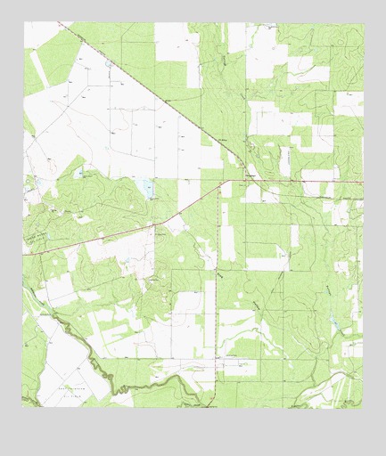
Brundage, TX USGS Topographic Map
Click on map above to begin viewing in our Map Viewer.

This topographic map contains these locations and features:
Feature Name Type Latitude Longitude GNIS ID View Map
Bermuda DamDamN28.5303°W99.7392°1351911View Map
Bermuda LakeReservoirN28.5332°W99.7435°1351912View Map
BrundagePopulated PlaceN28.5741°W99.6687°1353013View Map
Brundage Census Designated PlaceCensusN28.5740°W99.6701°2407910View Map
East Thirteen Oil FieldOilfieldN28.5053°W99.7326°1356724View Map
El Barrosa CreekStreamN28.5025°W99.7495°1372121View Map
Indian Mound Oil FieldOilfieldN28.5539°W99.7428°1359969View Map
J N SidingLocaleN28.5864°W99.6778°1360066View Map
Quatro Ranch Airport (historical)AirportN28.5811°W99.6534°1386252View Map
Reynolds and Wilson Lake Number 1ReservoirN28.5764°W99.7289°1865125View Map
Reynolds and Wilson Lake Number 1 DamDamN28.5769°W99.7287°1865124View Map
Reynolds and Wilson Lake Number 2ReservoirN28.5719°W99.7037°1865127View Map
Reynolds and Wilson Lake Number 2 DamDamN28.5719°W99.7037°1865126View Map
Reynolds-Wilson LakeReservoirN28.5703°W99.7020°1858843View Map
Reynolds-Wilson Lake DamDamN28.5703°W99.7020°1858842View Map
Soldier SloughStreamN28.5011°W99.6842°1376171View Map
Stag HollowValleyN28.5168°W99.6428°1369082View Map

Note: Coordinates in the location and feature list above are referenced to NAD83 datum.


Copyright (C) 2008-2024 Ryan Niemi / Sunset Dynamics ... All Rights Reserved