TopoQuest Logo
Do you find TopoQuest useful?
Help keep TopoQuest running and adding new maps/features by donating!
Bitcoin:  19c7KJd3qBynnjoSw5npx9KScwjBe4ifkT
Litecoin:  LXs6TkuXGGXo1vDsWCkWVdjQX94eUKd6ui
Home View Maps Find Maps Find Places Resources & Links


Brownville Junction, Maine Topographic Map

USGS Map Title: Brownville Junction, ME
USGS Map MRC: 45069C1
DRG (GeoTIFF) Download: o45069c1.tif


Neighboring USGS Topographic Map Quads:


  Silver Lake, ME  
45069D2
 

  Ebeemee Mountain, ME  
45069D1
 

  Seboeis Lake, ME  
45068D8
 

  Sebec Lake East, ME  
45069C2
 

  Brownville Junction, ME  
45069C1
 

  Milo North, ME  
45068C8
 

  Dover-Foxcroft, ME  
45069B2
 

  South Sebec, ME  
45069B1
 

  Milo South, ME  
45068B8


Map MRC Location:

N46°
W70°
N46°
W69°
H8 H7 H6 H5 H4 H3 H2 H1
G8 G7 G6 G5 G4 G3 G2 G1
F8 F7 F6 F5 F4 F3 F2 F1
E8 E7 E6 E5 E4 E3 E2 E1
D8 D7 D6 D5 D4 D3 D2 D1
C8 C7 C6 C5 C4 C3 C2 C1
B8 B7 B6 B5 B4 B3 B2 B1
A8 A7 A6 A5 A4 A3 A2 A1
N45°
W70°
N45°
W69°

Brownville Junction, ME USGS 1:24K Topographic Map Preview:
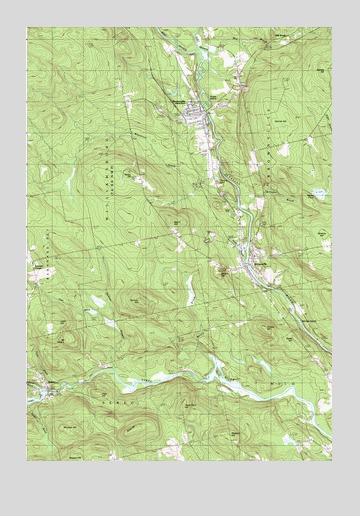
Brownville Junction, ME USGS Topographic Map
Click on map above to begin viewing in our Map Viewer.

This topographic map contains these locations and features:
Feature Name Type Latitude Longitude GNIS ID View Map
Abbee PondLakeN45.3270°W69.0053°561041View Map
Alder BrookStreamN45.2895°W69.0892°561138View Map
Badger BrookStreamN45.2659°W69.1242°561425View Map
Bailey HillSummitN45.3335°W69.0825°561440View Map
Barnard CemeteryCemeteryN45.3010°W69.1201°2736944View Map
Barnard CornerPopulated PlaceN45.3073°W69.1231°579118View Map
Barnard SchoolSchoolN45.3014°W69.1214°561622View Map
Brown HillSummitN45.3041°W69.0459°563053View Map
BrownvillePopulated PlaceN45.3070°W69.0334°563084View Map
Brownville Elementary SchoolSchoolN45.3224°W69.0419°1910021View Map
Brownville Fire Department Junction Fire StationBuildingN45.3500°W69.0556°2553184View Map
Brownville Fire Department Village StationBuildingN45.3074°W69.0328°2553229View Map
Brownville JunctionPopulated PlaceN45.3501°W69.0523°563085View Map
Brownville Junction Post OfficePost OfficeN45.3500°W69.0555°1910022View Map
Brownville Police DepartmentBuildingN45.3224°W69.0421°2735821View Map
Brownville Post OfficePost OfficeN45.3067°W69.0332°1910023View Map
Brownville Public LibraryBuildingN45.3067°W69.0331°1910024View Map
Buck HillSummitN45.2595°W69.0798°563105View Map
Downs CemeteryCemeteryN45.2511°W69.0908°2736950View Map
East Branch Pleasant RiverStreamN45.3656°W69.0539°565567View Map
Gerrish HillSummitN45.3489°W69.0176°566760View Map
Gillman BrookStreamN45.2703°W69.1187°566795View Map
Gray HillSummitN45.2695°W69.0956°567100View Map
Herrick IslandIslandN45.2895°W69.0128°567968View Map
Hoxie CemeteryCemeteryN45.2581°W69.0596°2736964View Map
Jenks BrookStreamN45.3084°W69.0356°568797View Map
Ladd HillSummitN45.2900°W69.1126°569296View Map
Maquire HillSummitN45.2570°W69.0420°570751View Map
Merrill BrookStreamN45.2756°W69.0478°571153View Map
Merrill HillSummitN45.3186°W69.0657°571164View Map
Mill BrookPopulated PlaceN45.3720°W69.0217°579523View Map
Mill BrookStreamN45.3678°W69.0517°571305View Map
Moulton HillSummitN45.2585°W69.1039°571748View Map
Mount MiserySummitN45.2848°W69.1078°571459View Map
Perham HillSummitN45.2961°W69.0782°573194View Map
Pine Tree CemeteryCemeteryN45.3591°W69.0383°573406View Map
Pleasant River DamDamN45.3069°W69.0348°1773805View Map
Pleasant River ReservoirReservoirN45.3069°W69.0348°1773806View Map
Salmon StreamStreamN45.2767°W69.0892°574778View Map
SebecPopulated PlaceN45.2714°W69.1167°575165View Map
Sebec DamDamN45.2703°W69.1156°1773809View Map
Sebec Fire DepartmentBuildingN45.2733°W69.1174°2553230View Map
Sebec Village CemeteryCemeteryN45.2745°W69.1188°1910173View Map
Sebec Village Cemetery Cowan ExtensionCemeteryN45.2742°W69.1194°2727253View Map
Sebec Village Community Christian ChurchChurchN45.2742°W69.1181°1910174View Map
Sugar IslandIslandN45.3545°W69.0528°576499View Map
Swett HillSummitN45.2852°W69.0150°576612View Map
Tannery PondLakeN45.3315°W69.0471°576650View Map
Town Farm HillSummitN45.2653°W69.0606°577228View Map
Town of BrownvilleCivilN45.3595°W69.0096°582374View Map
Trout BrookStreamN45.2723°W69.1103°577332View Map
Varney HillSummitN45.2887°W69.0278°577697View Map
Village CemeteryCemeteryN45.3084°W69.0306°1910203View Map
Weaver HillSummitN45.2513°W69.1035°577917View Map
Webber Jones AirportAirportN45.3361°W69.0499°582120View Map
West Branch Pleasant RiverStreamN45.3656°W69.0537°578082View Map
Whetstone BrookStreamN45.3239°W69.0395°578319View Map
Williams BrookStreamN45.3209°W69.0323°578509View Map
Williamsburg SchoolSchoolN45.3537°W69.0859°578526View Map
Williamsburg TownshipCivilN45.3544°W69.1105°1987388View Map

Note: Coordinates in the location and feature list above are referenced to NAD83 datum.


Copyright (C) 2008-2024 Ryan Niemi / Sunset Dynamics ... All Rights Reserved