TopoQuest Logo
Do you find TopoQuest useful?
Help keep TopoQuest running and adding new maps/features by donating!
Bitcoin:  19c7KJd3qBynnjoSw5npx9KScwjBe4ifkT
Litecoin:  LXs6TkuXGGXo1vDsWCkWVdjQX94eUKd6ui
Home View Maps Find Maps Find Places Resources & Links


Brodhead, Kentucky Topographic Map

USGS Map Title: Brodhead, KY
USGS Map MRC: 37084D4
DRG (GeoTIFF) Download: o37084d4.tif


Neighboring USGS Topographic Map Quads:


  Lancaster, KY  
37084E5
 

  Paint Lick, KY  
37084E4
 

  Berea, KY  
37084E3
 

  Crab Orchard, KY  
37084D5
 

  Brodhead, KY  
37084D4
 

  Wildie, KY  
37084D3
 

  Woodstock, KY  
37084C5
 

  Maretburg, KY  
37084C4
 

  Mount Vernon, KY  
37084C3


Map MRC Location:

N38°
W85°
N38°
W84°
H8 H7 H6 H5 H4 H3 H2 H1
G8 G7 G6 G5 G4 G3 G2 G1
F8 F7 F6 F5 F4 F3 F2 F1
E8 E7 E6 E5 E4 E3 E2 E1
D8 D7 D6 D5 D4 D3 D2 D1
C8 C7 C6 C5 C4 C3 C2 C1
B8 B7 B6 B5 B4 B3 B2 B1
A8 A7 A6 A5 A4 A3 A2 A1
N37°
W85°
N37°
W84°

Brodhead, KY USGS 1:24K Topographic Map Preview:
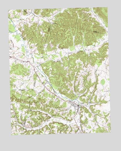
Brodhead, KY USGS Topographic Map
Click on map above to begin viewing in our Map Viewer.

This topographic map contains these locations and features:
Feature Name Type Latitude Longitude GNIS ID View Map
Albright GraveyardCemeteryN37.4537°W84.4895°2566701View Map
Boone ForkStreamN37.4042°W84.4138°487690View Map
Bowling RidgeRidgeN37.4037°W84.4519°487746View Map
Bowman BranchStreamN37.4013°W84.4032°487747View Map
Brock CemeteryCemeteryN37.4606°W84.4022°487944View Map
BrodheadPopulated PlaceN37.4042°W84.4138°487947View Map
Brodhead Fire DepartmentBuildingN37.4028°W84.4147°2636737View Map
Brodhead Railroad Station (historical)LocaleN37.4019°W84.4141°2725995View Map
Christian Assembly CampgroundLocaleN37.4170°W84.4256°2726007View Map
City of BrodheadCivilN37.4027°W84.4144°2403930View Map
Copper CreekStreamN37.4570°W84.4716°511529View Map
Copper Creek School (historical)SchoolN37.4824°W84.3837°2564701View Map
Cupps ChapelChurchN37.4579°W84.4249°490491View Map
Dripping Spring Post Office (historical)Post OfficeN37.4975°W84.4684°2564706View Map
Dripping Spring Resort (historical)LocaleN37.4962°W84.4667°2564707View Map
Fall LickStreamN37.4884°W84.4938°491947View Map
Fall Lick (historical)Populated PlaceN37.4907°W84.4852°2742212View Map
Flax CreekStreamN37.4645°W84.4841°492232View Map
Gentontown (historical)Populated PlaceN37.4517°W84.4607°2742213View Map
Grassy BranchStreamN37.4091°W84.4183°493140View Map
Gum Grove SchoolSchoolN37.4643°W84.3908°493482View Map
Gum Sulpher Post Office (historical)Post OfficeN37.4276°W84.4537°2726088View Map
Gum Sulpher Railroad Station (historical)LocaleN37.4274°W84.4536°2726024View Map
Gum SulphurPopulated PlaceN37.4270°W84.4594°493492View Map
Hamilton ValleyValleyN37.4888°W84.4480°493627View Map
Holdams Mill (historical)Populated PlaceN37.4063°W84.4812°2742218View Map
Indian BranchStreamN37.4973°W84.4694°494910View Map
Indian KnobSummitN37.4112°W84.4641°494973View Map
Long BranchStreamN37.4097°W84.4173°497032View Map
MaywoodLocaleN37.4896°W84.4184°2564753View Map
Millers KnobSummitN37.4131°W84.4760°498360View Map
Negro CreekStreamN37.4042°W84.4138°499236View Map
Negro Creek CemeteryCemeteryN37.3890°W84.4552°499237View Map
Negro Creek SchoolSchoolN37.3934°W84.4488°499238View Map
Old Moss CemeteryCemeteryN37.4265°W84.4852°499858View Map
Piney Grove CemeteryCemeteryN37.4081°W84.4247°500732View Map
Slaty BranchStreamN37.4323°W84.4524°503661View Map
Stigalls Stand (historical)LocaleN37.4021°W84.4146°2726058View Map
Tarkin BranchStreamN37.3901°W84.4458°504965View Map
Thompson Store (historical)Populated PlaceN37.3805°W84.4912°2566688View Map
Turkey CreekStreamN37.4423°W84.4638°505597View Map
TurkeytownPopulated PlaceN37.4206°W84.4869°509246View Map
Turkeytown School (historical)SchoolN37.4198°W84.4866°2566690View Map
Union ChapelChurchN37.4201°W84.3772°505771View Map
Valley ChurchChurchN37.4806°W84.3780°505938View Map
Watts Chapel Baptist ChurchChurchN37.4484°W84.4808°506295View Map
Watts Chapel School (historical)SchoolN37.4482°W84.4819°2566694View Map
Wilmot CemeteryCemeteryN37.4748°W84.3760°506875View Map
Wilmot ChurchChurchN37.4504°W84.4363°506876View Map
Wilmot Church (historical)Populated PlaceN37.4479°W84.4373°2726282View Map

Note: Coordinates in the location and feature list above are referenced to NAD83 datum.


Copyright (C) 2008-2024 Ryan Niemi / Sunset Dynamics ... All Rights Reserved