TopoQuest Logo
Do you find TopoQuest useful?
Help keep TopoQuest running and adding new maps/features by donating!
Bitcoin:  19c7KJd3qBynnjoSw5npx9KScwjBe4ifkT
Litecoin:  LXs6TkuXGGXo1vDsWCkWVdjQX94eUKd6ui
Home View Maps Find Maps Find Places Resources & Links


Bowerston, Ohio Topographic Map

USGS Map Title: Bowerston, OH
USGS Map MRC: 40081D2
DRG (GeoTIFF) Download: o40081d2.tif


Neighboring USGS Topographic Map Quads:


  Mineral City, OH  
40081E3
 

  Dellroy, OH  
40081E2
 

  Carrollton, OH  
40081E1
 

  Uhrichsville, OH  
40081D3
 

  Bowerston, OH  
40081D2
 

  Scio, OH  
40081D1
 

  Tippecanoe, OH  
40081C3
 

  Deersville, OH  
40081C2
 

  Jewett, OH  
40081C1


Map MRC Location:

N41°
W82°
N41°
W81°
H8 H7 H6 H5 H4 H3 H2 H1
G8 G7 G6 G5 G4 G3 G2 G1
F8 F7 F6 F5 F4 F3 F2 F1
E8 E7 E6 E5 E4 E3 E2 E1
D8 D7 D6 D5 D4 D3 D2 D1
C8 C7 C6 C5 C4 C3 C2 C1
B8 B7 B6 B5 B4 B3 B2 B1
A8 A7 A6 A5 A4 A3 A2 A1
N40°
W82°
N40°
W81°

Bowerston, OH USGS 1:24K Topographic Map Preview:
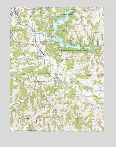
Bowerston, OH USGS Topographic Map
Click on map above to begin viewing in our Map Viewer.

This topographic map contains these locations and features:
Feature Name Type Latitude Longitude GNIS ID View Map
Bethel CemeteryCemeteryN40.4927°W81.1848°1052486View Map
BowerstonPopulated PlaceN40.4253°W81.1879°1048536View Map
Bowerston Elementary SchoolSchoolN40.4231°W81.1832°1052089View Map
Bowerston Post OfficePost OfficeN40.4251°W81.1873°1994138View Map
Bowerston Public LibraryBuildingN40.4262°W81.1901°1807015View Map
Bowerston Volunteer Fire DepartmentBuildingN40.4256°W81.1888°2549969View Map
Camp AldersgateLocaleN40.4917°W81.1712°1960649View Map
Camp FalconLocaleN40.4728°W81.1890°1960650View Map
Camp MuskingumLocaleN40.4953°W81.1693°1038729View Map
Church of ChristChurchN40.4098°W81.1490°1039104View Map
Clover Leaf MineMineN40.4251°W81.1937°1731284View Map
Clows MarinaLocaleN40.4656°W81.1845°1960652View Map
ConottonPopulated PlaceN40.4173°W81.1465°1056834View Map
Conotton CemeteryCemeteryN40.4103°W81.1487°1699589View Map
Conotton Post Office (historical)Post OfficeN40.4167°W81.1470°1993512View Map
Conotton Valley High SchoolSchoolN40.4626°W81.2190°1039317View Map
Cross MineMineN40.3862°W81.2170°1731289View Map
Dover LakeLakeN40.4820°W81.2373°1039764View Map
Edwards MineMineN40.3965°W81.2454°1731295View Map
Firebird CampLocaleN40.4890°W81.1868°1040449View Map
Glens Cottage AreaPopulated PlaceN40.4876°W81.1912°1960654View Map
HazeltonPopulated PlaceN40.4953°W81.2304°1052478View Map
Heller CemeteryCemeteryN40.4101°W81.2037°1041473View Map
Holmes RunStreamN40.4812°W81.2248°1041680View Map
Lakeshore ParkPopulated PlaceN40.4642°W81.1690°1052483View Map
LeesvillePopulated PlaceN40.4517°W81.2120°1064981View Map
Leesville CemeteryCemeteryN40.4551°W81.2112°1052479View Map
Leesville DamDamN40.4684°W81.1948°1077635View Map
Leesville GlensPopulated PlaceN40.4878°W81.1915°1052485View Map
Leesville HillsPopulated PlaceN40.4592°W81.1720°1052482View Map
Leesville LakeReservoirN40.4600°W81.1628°1070812View Map
Leesville Lake ParkPopulated PlaceN40.4570°W81.1832°1052481View Map
Leesville Post OfficePost OfficeN40.4515°W81.2123°1965233View Map
Leesville Volunteer Fire DepartmentBuildingN40.4521°W81.2130°2550506View Map
Leesville Wildlife AreaParkN40.4773°W81.1804°1042478View Map
Longview CemeteryCemeteryN40.4326°W81.1870°1042773View Map
McGuire CreekStreamN40.4751°W81.2176°1066093View Map
Meechan MineMineN40.3915°W81.2459°1731313View Map
Mount Olive CemeteryCemeteryN40.4490°W81.1379°1052488View Map
Mount Tabor CemeteryCemeteryN40.4817°W81.1482°1052489View Map
New HagerstownPopulated PlaceN40.4434°W81.1870°1065118View Map
New Hagerstown CemeteryCemeteryN40.4448°W81.1893°1052480View Map
New Hagerstown Post Office (historical)Post OfficeN40.4431°W81.1873°1083279View Map
Newton MineMineN40.3959°W81.2354°1731314View Map
North Fork McGuire CreekStreamN40.4723°W81.1932°1066113View Map
PalermoPopulated PlaceN40.4901°W81.1545°1062929View Map
Palermo CemeteryCemeteryN40.4898°W81.1520°1052490View Map
Palermo Post Office (historical)Post OfficeN40.4903°W81.1540°1965531View Map
Pines Cottage AreaPopulated PlaceN40.4820°W81.1934°1960655View Map
Plum Run CemeteryCemeteryN40.3820°W81.2293°1699605View Map
Plum Run Hill Top CemeteryCemeteryN40.3814°W81.2323°1699606View Map
Plum Run Methodist ChurchChurchN40.3820°W81.2290°1044632View Map
Plum Run MineMineN40.3890°W81.2259°1731317View Map
Reichman MineMineN40.4223°W81.1851°1731318View Map
Rock Canyon ParkPopulated PlaceN40.4565°W81.1645°1052487View Map
Scott RunStreamN40.4165°W81.1443°1046069View Map
Semple RunStreamN40.4945°W81.1765°1046091View Map
SherrodsvillePopulated PlaceN40.4948°W81.2429°1049175View Map
Sherrodsville Elementary SchoolSchoolN40.4951°W81.2398°1052477View Map
Sherrodsville Post OfficePost OfficeN40.4945°W81.2429°1965240View Map
Sherrodsville Volunteer Fire Department Sherrodsville SquadBuildingN40.4942°W81.2428°2550579View Map
Stanley Lake 006ReservoirN40.4453°W81.2302°1078417View Map
Stanley Lake 007ReservoirN40.4442°W81.2364°1078419View Map
Stanley Lake Dam 006DamN40.4451°W81.2282°1078416View Map
Stanley Lake Dam 007DamN40.4451°W81.2348°1078418View Map
Tappan Lake MineMineN40.3809°W81.2182°1731325View Map
ThornhillPopulated PlaceN40.4823°W81.1934°1052484View Map
Township of MonroeCivilN40.4004°W81.2151°1086278View Map
Township of OrangeCivilN40.4661°W81.2134°1085833View Map
Tunnel Hill CemeteryCemeteryN40.4214°W81.2237°1699611View Map
Tunnel Hill ChurchChurchN40.4212°W81.2229°1047186View Map
Village of BowerstonCivilN40.4273°W81.1874°2398156View Map
Village of LeesvilleCivilN40.4521°W81.2096°2398412View Map
Village of SherrodsvilleCivilN40.4945°W81.2441°2399804View Map

Note: Coordinates in the location and feature list above are referenced to NAD83 datum.


Copyright (C) 2008-2024 Ryan Niemi / Sunset Dynamics ... All Rights Reserved