TopoQuest Logo
Do you find TopoQuest useful?
Help keep TopoQuest running and adding new maps/features by donating!
Bitcoin:  19c7KJd3qBynnjoSw5npx9KScwjBe4ifkT
Litecoin:  LXs6TkuXGGXo1vDsWCkWVdjQX94eUKd6ui
Home View Maps Find Maps Find Places Resources & Links


Bowdon West, Georgia Topographic Map

USGS Map Title: Bowdon West, GA
USGS Map MRC: 33085E3
DRG (GeoTIFF) Download: o33085e3.tif


Neighboring USGS Topographic Map Quads:


  Fruithurst, AL  
33085F4
 

  Tallapoosa South, GA  
33085F3
 

  Bremen, GA  
33085F2
 

  Hightower, AL  
33085E4
 

  Bowdon West, GA  
33085E3
 

  Bowdon East, GA  
33085E2
 

  Newell, AL  
33085D4
 

  Graham, AL  
33085D3
 

  Roopville, GA  
33085D2


Map MRC Location:

N34°
W86°
N34°
W85°
H8 H7 H6 H5 H4 H3 H2 H1
G8 G7 G6 G5 G4 G3 G2 G1
F8 F7 F6 F5 F4 F3 F2 F1
E8 E7 E6 E5 E4 E3 E2 E1
D8 D7 D6 D5 D4 D3 D2 D1
C8 C7 C6 C5 C4 C3 C2 C1
B8 B7 B6 B5 B4 B3 B2 B1
A8 A7 A6 A5 A4 A3 A2 A1
N33°
W86°
N33°
W85°

Bowdon West, GA USGS 1:24K Topographic Map Preview:
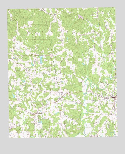
Bowdon West, GA USGS Topographic Map
Click on map above to begin viewing in our Map Viewer.

This topographic map contains these locations and features:
Feature Name Type Latitude Longitude GNIS ID View Map
Andersons Store (historical)LocaleN33.5593°W85.3491°146305View Map
BowdonPopulated PlaceN33.5379°W85.2533°354818View Map
Bowdon Area HospitalHospitalN33.5346°W85.2623°350071View Map
Bowdon Baptist CemeteryCemeteryN33.5398°W85.2574°350072View Map
Bowdon Baptist ChurchChurchN33.5396°W85.2574°350073View Map
Bowdon City CemeteryCemeteryN33.5426°W85.2563°350074View Map
Bowdon City HallBuildingN33.5379°W85.2519°350075View Map
Bowdon City JailBuildingN33.5379°W85.2519°2733973View Map
Bowdon Elementary SchoolSchoolN33.5273°W85.2501°350076View Map
Bowdon High SchoolSchoolN33.5382°W85.2619°350077View Map
Bowdon Open Campus High SchoolSchoolN33.5398°W85.2507°2545633View Map
Bowdon Police DepartmentBuildingN33.5379°W85.2519°2733760View Map
Bowdon Post OfficePost OfficeN33.5384°W85.2555°350078View Map
Bulldog StadiumParkN33.5232°W85.3480°1730317View Map
Carroll County Crossroads AcademySchoolN33.5401°W85.2508°2545513View Map
Carroll County Fire / Rescue Station 14BuildingN33.5996°W85.2943°2603983View Map
Cedar ValleyPopulated PlaceN33.5382°W85.2727°350749View Map
Central Church (historical)ChurchN33.6048°W85.3522°146309View Map
Chewacla Lime Works (historical)MineN33.5771°W85.3388°138125View Map
City of BowdonCivilN33.5378°W85.2540°2403902View Map
Cleburne Memorial GardenCemeteryN33.5368°W85.3733°146312View Map
Colefield School (historical)SchoolN33.6098°W85.3247°350114View Map
Cooks Mill (historical)LocaleN33.5809°W85.3555°146313View Map
Corinth CemeteryCemeteryN33.5018°W85.2761°350119View Map
Corinth ChurchChurchN33.5468°W85.3477°116637View Map
Corinth ChurchChurchN33.5012°W85.2761°355313View Map
First Methodist CemeteryCemeteryN33.5357°W85.2549°350145View Map
First Methodist ChurchChurchN33.5357°W85.2538°350146View Map
Flint Ridge ChurchChurchN33.5223°W85.2574°355848View Map
Garretts ChapelChurchN33.5940°W85.3130°314526View Map
Garretts Chapel CemeteryCemeteryN33.5943°W85.3130°349582View Map
Gibbs Store (historical)LocaleN33.5107°W85.3438°146317View Map
Hillcrest School (historical)SchoolN33.5826°W85.3041°349595View Map
Hudson SchoolSchoolN33.5268°W85.2505°315794View Map
Indian CreekStreamN33.5571°W85.2836°315890View Map
Indian Creek CemeteryCemeteryN33.5793°W85.2541°349601View Map
Indian Creek ChurchChurchN33.5798°W85.2547°315901View Map
Indian Creek School (historical)SchoolN33.5879°W85.2555°349602View Map
KansasLocaleN33.6212°W85.2702°316322View Map
Kansas CemeteryCemeteryN33.6226°W85.2699°349609View Map
Kansas Missionary Baptist ChurchChurchN33.6226°W85.2702°349610View Map
Little Lost CreekStreamN33.5276°W85.3547°121814View Map
Lost CreekStreamN33.5012°W85.3502°122033View Map
Lost Creek Lake Number 1ReservoirN33.5756°W85.3367°131614View Map
Lost Creek Lake Number 2ReservoirN33.5710°W85.3468°131610View Map
Lost Creek Lake Number 3ReservoirN33.5553°W85.3572°131606View Map
Lost Creek Lake Number 4ReservoirN33.5411°W85.3692°131603View Map
Lost Creek Watershed Dam Number 1DamN33.5718°W85.3366°131613View Map
Lost Creek Watershed Dam Number 2DamN33.5701°W85.3450°131611View Map
Lost Creek Watershed Dam Number 3DamN33.5551°W85.3566°131607View Map
Lost Creek Watershed Dam Number 4DamN33.5401°W85.3683°131604View Map
Lovvarn Mill (historical)LocaleN33.5512°W85.2622°349623View Map
MacedoniaPopulated PlaceN33.5773°W85.3708°156646View Map
Macedonia Baptist ChurchChurchN33.5801°W85.3455°122165View Map
Macedonia CemeteryCemeteryN33.5793°W85.3455°1730339View Map
Macedonia School (historical)SchoolN33.5687°W85.3438°150972View Map
Melrose School (historical)SchoolN33.5446°W85.3088°349635View Map
Mount View CemeteryCemeteryN33.6190°W85.3222°349654View Map
Mount View ChurchChurchN33.6190°W85.3227°318917View Map
New Hope ChurchChurchN33.5212°W85.2588°319418View Map
Overton School (historical)SchoolN33.5034°W85.3277°146329View Map
Poplar Spring ChurchChurchN33.6015°W85.2741°321034View Map
Poplar Springs CemeteryCemeteryN33.6015°W85.2736°349693View Map
RanburnePopulated PlaceN33.5229°W85.3447°153111View Map
Ranburne Fire and RescueBuildingN33.5308°W85.3350°2682968View Map
Ranburne High SchoolSchoolN33.5232°W85.3463°146332View Map
Ranburne Post OfficePost OfficeN33.5252°W85.3425°2789070View Map
Ranburne Town Police DepartmentBuildingN33.5253°W85.3424°2751854View Map
Robinson Lake Number 2ReservoirN33.5105°W85.3725°131578View Map
Robinson Number 2 DamDamN33.5104°W85.3702°131579View Map
Robinsons Store (historical)LocaleN33.5593°W85.3255°146333View Map
Sandy Flat CemeteryCemeteryN33.5176°W85.3008°349713View Map
Sandy Flat ChurchChurchN33.5173°W85.3008°322479View Map
Skinners Store (historical)LocaleN33.5798°W85.3361°146334View Map
Solomon (historical)LocaleN33.5454°W85.3647°154261View Map
Stitcher LakeReservoirN33.5708°W85.2879°339656View Map
Stitcher Lake DamDamN33.5701°W85.2866°339655View Map
Teague LakeReservoirN33.6164°W85.2906°339346View Map
Town CemeteryCemeteryN33.5415°W85.2561°324245View Map
Town of RanburneCivilN33.5259°W85.3390°2407173View Map
Turkey CreekStreamN33.5662°W85.2536°324382View Map
Warren P Sewell Memorial LibraryBuildingN33.5440°W85.2572°349764View Map
Winston Post Office (historical)Post OfficeN33.5098°W85.3591°166188View Map
Woodrow School (historical)SchoolN33.5523°W85.3477°146342View Map
Zuejnieks LakeReservoirN33.5958°W85.3062°339658View Map
Zuejnieks Lake DamDamN33.5951°W85.3066°339657View Map

Note: Coordinates in the location and feature list above are referenced to NAD83 datum.


Copyright (C) 2008-2024 Ryan Niemi / Sunset Dynamics ... All Rights Reserved