TopoQuest Logo
Do you find TopoQuest useful?
Help keep TopoQuest running and adding new maps/features by donating!
Bitcoin:  19c7KJd3qBynnjoSw5npx9KScwjBe4ifkT
Litecoin:  LXs6TkuXGGXo1vDsWCkWVdjQX94eUKd6ui
Home View Maps Find Maps Find Places Resources & Links


Zuni, New Mexico Topographic Map

USGS Map Title: Zuni, NM
USGS Map MRC: 35108A7
DRG (GeoTIFF) Download: o35108a7.tif


Neighboring USGS Topographic Map Quads:


  Chi Chil Tah, NM  
35108B8
 

  Vanderwagen Draw, NM  
35108B7
 

  Horsehead Canyon NW, NM  
35108B6
 

  Tekapo, NM  
35108A8
 

  Zuni, NM  
35108A7
 

  Horsehead Canyon, NM  
35108A6
 

  Ojo Caliente Reservoir, NM  
34108H8
 

  Plumasano Basin, NM  
34108H7
 

  Upper Galestina Canyon, NM  
34108H6


Map MRC Location:

N36°
W109°
N36°
W108°
H8 H7 H6 H5 H4 H3 H2 H1
G8 G7 G6 G5 G4 G3 G2 G1
F8 F7 F6 F5 F4 F3 F2 F1
E8 E7 E6 E5 E4 E3 E2 E1
D8 D7 D6 D5 D4 D3 D2 D1
C8 C7 C6 C5 C4 C3 C2 C1
B8 B7 B6 B5 B4 B3 B2 B1
A8 A7 A6 A5 A4 A3 A2 A1
N35°
W109°
N35°
W108°

Zuni, NM USGS 1:24K Topographic Map Preview:
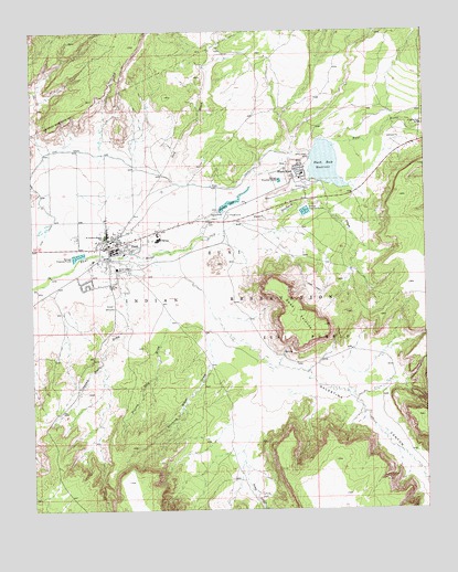
Zuni, NM USGS Topographic Map
Click on map above to begin viewing in our Map Viewer.

This topographic map contains these locations and features:
Feature Name Type Latitude Longitude GNIS ID View Map
Black RockPopulated PlaceN35.0884°W108.7912°899539View Map
Black RockSpringN35.1017°W108.7712°917574View Map
Black Rock AirportAirportN35.0832°W108.7918°937044View Map
Black Rock Census Designated PlaceCensusN35.0833°W108.7979°2407858View Map
Black Rock DamDamN35.0950°W108.7873°923912View Map
Black Rock Post Office (historical)Post OfficeN35.0884°W108.7912°938464View Map
Black Rock ReservoirReservoirN35.0900°W108.7820°898249View Map
Dowa YalanneSummitN35.0528°W108.7923°902817View Map
Dowa Yalanne SchoolSchoolN35.0634°W108.8487°888498View Map
Eustace DamDamN35.0800°W108.8156°923915View Map
Eustace LakeReservoirN35.0803°W108.8119°888934View Map
Galestina CanyonValleyN35.0528°W108.8190°902823View Map
Heshotauthla Historic SiteLocaleN35.0695°W108.8484°933750View Map
Kechiba:wa RuinLocaleN35.0695°W108.8484°936066View Map
KSHI-FM (Zuni)TowerN35.0884°W108.7901°938705View Map
Kwa'kin'a Historic SiteLocaleN35.0695°W108.8484°933676View Map
Kyaki:ma Historic SiteLocaleN35.0695°W108.8479°933672View Map
Mullen CanyonValleyN35.0175°W108.8090°892334View Map
Museum of ZuniBuildingN35.0695°W108.8484°929488View Map
Oak WashStreamN35.0828°W108.8626°892801View Map
Ojo PuebloLocaleN35.0703°W108.8484°936013View Map
Peach Orchard DrawValleyN35.0731°W108.8131°893133View Map
Prairie Dog DrawValleyN35.0509°W108.8315°893457View Map
Pueblo de los Muertos Historic SiteLocaleN35.0695°W108.8484°934417View Map
Pueblo of Zuni Historical MarkerParkN35.0695°W108.8484°932325View Map
Pueblo of Zuni Volunteer Fire and Emergency Medical Services Station 1 Black RockBuildingN35.0858°W108.7898°2657766View Map
Saint Anthony Mission SchoolSchoolN35.0720°W108.8523°894267View Map
Saint Anthony ParishChurchN35.0695°W108.8484°921256View Map
Saint Anthony Zuni Indian SchoolSchoolN35.0695°W108.8484°939228View Map
Soldado RuinLocaleN35.0695°W108.8409°935934View Map
Stinking Water DrawValleyN35.0450°W108.8176°895357View Map
Trapped Rock DrawValleyN35.0614°W108.8440°895804View Map
Village Fire Station 2BuildingN35.0725°W108.8477°2657720View Map
Village of the Great Kivas Historic SiteLocaleN35.0695°W108.8484°933640View Map
Yellow House Historic SiteLocaleN35.0695°W108.8484°933764View Map
ZuniPopulated PlaceN35.0695°W108.8484°902857View Map
Zuni - Ramah Service Unit Zuni Indian Health Service HospitalHospitalN35.0872°W108.7912°924843View Map
Zuni CanalCanalN35.0895°W108.8406°896853View Map
Zuni Christian Reformed Mission SchoolSchoolN35.0695°W108.8484°934182View Map
Zuni DivisionCivilN35.0940°W108.7622°1937620View Map
Zuni Mission Historic SiteChurchN35.1195°W108.8484°935169View Map
Zuni Police DepartmentBuildingN35.0706°W108.8462°2722499View Map
Zuni Post OfficePost OfficeN35.0705°W108.8456°937618View Map
Zuni PuebloPopulated PlaceN35.0725°W108.8506°1867391View Map
Zuni Pueblo Census Designated PlaceCensusN35.0707°W108.8484°2409649View Map
Zuņi Pueblo GrantCivilN35.0445°W108.7898°902858View Map
Zuni ReservationCivilN35.0181°W108.8122°1934346View Map
Zuni Weather StationLocaleN35.0695°W108.8484°931778View Map

Note: Coordinates in the location and feature list above are referenced to NAD83 datum.


Copyright (C) 2008-2024 Ryan Niemi / Sunset Dynamics ... All Rights Reserved