TopoQuest Logo
Do you find TopoQuest useful?
Help keep TopoQuest running and adding new maps/features by donating!
Bitcoin:  19c7KJd3qBynnjoSw5npx9KScwjBe4ifkT
Litecoin:  LXs6TkuXGGXo1vDsWCkWVdjQX94eUKd6ui
Home View Maps Find Maps Find Places Resources & Links


Yemassee, South Carolina Topographic Map

USGS Map Title: Yemassee, SC
USGS Map MRC: 32080F7
DRG (GeoTIFF) Download: o32080f7.tif


Neighboring USGS Topographic Map Quads:


  Cummings, SC  
32080G8
 

  Black Creek, SC  
32080G7
 

  Hendersonville, SC  
32080G6
 

  McPhersonville, SC  
32080F8
 

  Yemassee, SC  
32080F7
 

  White Hall, SC  
32080F6
 

  Coosawhatchie, SC  
32080E8
 

  Sheldon, SC  
32080E7
 

  Dale, SC  
32080E6


Map MRC Location:

N33°
W81°
N33°
W80°
H8 H7 H6 H5 H4 H3 H2 H1
G8 G7 G6 G5 G4 G3 G2 G1
F8 F7 F6 F5 F4 F3 F2 F1
E8 E7 E6 E5 E4 E3 E2 E1
D8 D7 D6 D5 D4 D3 D2 D1
C8 C7 C6 C5 C4 C3 C2 C1
B8 B7 B6 B5 B4 B3 B2 B1
A8 A7 A6 A5 A4 A3 A2 A1
N32°
W81°
N32°
W80°

Yemassee, SC USGS 1:24K Topographic Map Preview:
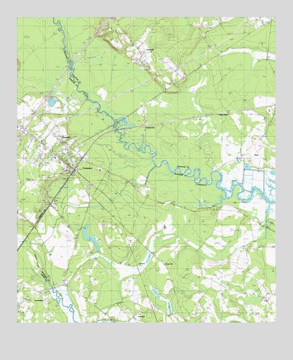
Yemassee, SC USGS Topographic Map
Click on map above to begin viewing in our Map Viewer.

This topographic map contains these locations and features:
Feature Name Type Latitude Longitude GNIS ID View Map
Auld Brass PlantationLocaleN32.6807°W80.8118°1237115View Map
Bindon PlantationLocaleN32.6257°W80.8407°1237139View Map
BlakePopulated PlaceN32.6918°W80.7693°1231060View Map
Blake SidingLocaleN32.7116°W80.7737°1246912View Map
BlountvillePopulated PlaceN32.6966°W80.8515°1231063View Map
BrewtonPopulated PlaceN32.6510°W80.8059°1231082View Map
Brewton PlantationLocaleN32.6646°W80.8037°1237147View Map
Castle Hall PlantationLocaleN32.6549°W80.8387°1237158View Map
Cherokee PlantationLocaleN32.6971°W80.7559°1240585View Map
Cherokee School (historical)SchoolN32.6938°W80.7637°1240586View Map
Coe PlantationLocaleN32.6913°W80.7626°1240590View Map
Colleton Fire Department Station 13BuildingN32.7368°W80.8169°2368334View Map
Cotton Hall PlantationLocaleN32.6310°W80.8151°1237179View Map
Fennell Elementary SchoolSchoolN32.6928°W80.8565°1232154View Map
Fort Balfour (historical)MilitaryN32.6394°W80.8569°1237199View Map
Gregorie PondSwampN32.6796°W80.8559°1248888View Map
Interchange 38CrossingN32.7043°W80.8712°1228303View Map
Jasper Fire Department Station 33BuildingN32.6289°W80.8739°2368314View Map
Jericho PlantationLocaleN32.6427°W80.8379°1237254View Map
Jones ChapelChurchN32.7080°W80.8634°1232175View Map
JonesvillePopulated PlaceN32.7363°W80.8159°1231436View Map
Jonesville Elementary SchoolSchoolN32.7330°W80.8059°1240663View Map
Mount Nebo ChurchChurchN32.7257°W80.7943°1240683View Map
Mount Nevo ChurchChurchN32.7268°W80.7929°1224740View Map
PocotaligoPopulated PlaceN32.6371°W80.8634°1231674View Map
Pocotaligo ChurchChurchN32.6268°W80.8296°1237324View Map
Pocotaligo School (historical)SchoolN32.6382°W80.8607°1241552View Map
Roadside School (historical)SchoolN32.7485°W80.7534°1240724View Map
Rose HillPopulated PlaceN32.6518°W80.7990°1231746View Map
SalkehatchiePopulated PlaceN32.7063°W80.8132°1250733View Map
Salkehatchie CemeteryCemeteryN32.7113°W80.8618°1232208View Map
Saltketcher BridgeBridgeN32.7068°W80.8273°1240735View Map
Thicken Ham PlantationLocaleN32.6557°W80.7651°1237405View Map
TomotleyPopulated PlaceN32.6318°W80.8151°1231867View Map
Town of YemasseeCivilN32.6928°W80.8546°2406926View Map
YemasseePopulated PlaceN32.6902°W80.8507°1227730View Map
Yemassee Fire Department Station 70BuildingN32.6954°W80.8512°2368333View Map
Yemassee Police DepartmentBuildingN32.6954°W80.8511°2334886View Map
Yemassee Post OfficePost OfficeN32.6899°W80.8481°2489900View Map
Yemassee School (historical)SchoolN32.7002°W80.8540°1248901View Map

Note: Coordinates in the location and feature list above are referenced to NAD83 datum.


Copyright (C) 2008-2024 Ryan Niemi / Sunset Dynamics ... All Rights Reserved