TopoQuest Logo
Do you find TopoQuest useful?
Help keep TopoQuest running and adding new maps/features by donating!
Bitcoin:  19c7KJd3qBynnjoSw5npx9KScwjBe4ifkT
Litecoin:  LXs6TkuXGGXo1vDsWCkWVdjQX94eUKd6ui
Home View Maps Find Maps Find Places Resources & Links


Worthington North, Minnesota Topographic Map

USGS Map Title: Worthington North, MN
USGS Map MRC: 43095F5
DRG (GeoTIFF) Download: o43095f5.tif


Neighboring USGS Topographic Map Quads:


  Fulda SW, MN  
43095G6
 

  Fulda, MN  
43095G5
 

  Dundee, MN  
43095G4
 

  Reading, MN  
43095F6
 

  Worthington North, MN  
43095F5
 

  Brewster, MN  
43095F4
 

  Bigelow, MN  
43095E6
 

  Worthington South, MN  
43095E5
 

  Round Lake, MN  
43095E4


Map MRC Location:

N44°
W96°
N44°
W95°
H8 H7 H6 H5 H4 H3 H2 H1
G8 G7 G6 G5 G4 G3 G2 G1
F8 F7 F6 F5 F4 F3 F2 F1
E8 E7 E6 E5 E4 E3 E2 E1
D8 D7 D6 D5 D4 D3 D2 D1
C8 C7 C6 C5 C4 C3 C2 C1
B8 B7 B6 B5 B4 B3 B2 B1
A8 A7 A6 A5 A4 A3 A2 A1
N43°
W96°
N43°
W95°

Worthington North, MN USGS 1:24K Topographic Map Preview:
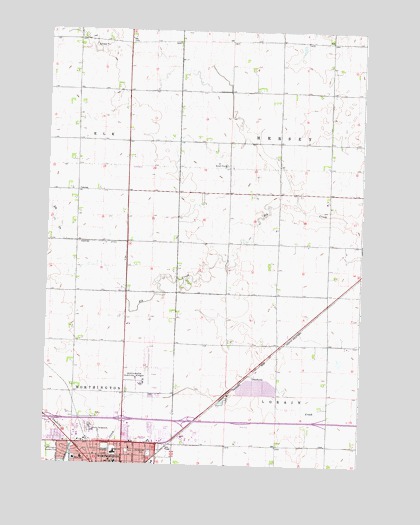
Worthington North, MN USGS Topographic Map
Click on map above to begin viewing in our Map Viewer.

This topographic map contains these locations and features:
Feature Name Type Latitude Longitude GNIS ID View Map
American Lutheran ChurchChurchN43.6255°W95.6086°2048902View Map
American Reformed ChurchChurchN43.6277°W95.6003°2048913View Map
Assemblies of God ChurchChurchN43.6277°W95.6003°2048909View Map
Bristol ParkParkN43.6291°W95.6053°2048944View Map
Calvary Independent Baptist ChurchChurchN43.6255°W95.5950°2048898View Map
Castlewood Knolls ParkParkN43.6372°W95.5781°2048942View Map
Christian SchoolSchoolN43.6291°W95.5845°641193View Map
Church of ChristChurchN43.6277°W95.6003°2048908View Map
City of WorthingtonCivilN43.6282°W95.5981°2397378View Map
Crossroads Care CenterHospitalN43.6264°W95.6031°2048888View Map
Full Gospel ChurchChurchN43.6277°W95.6003°2048910View Map
Interchange 42CrossingN43.6377°W95.6225°2049062View Map
Interchange 43CrossingN43.6380°W95.5933°2049061View Map
Interchange 45CrossingN43.6377°W95.5670°2049060View Map
Interchange 47CrossingN43.6377°W95.5142°2049059View Map
Intercity ParkParkN43.6252°W95.5872°2048939View Map
Judicial Ditch Number EightCanalN43.6889°W95.6145°645990View Map
Kelly ParkParkN43.6327°W95.6164°2048943View Map
Kingdom Hall of Jehovah's WitnessesChurchN43.6277°W95.6003°2048911View Map
Millard Walker ParkParkN43.6289°W95.5920°2048945View Map
Nobles County FairgroundsLocaleN43.6347°W95.6031°2048930View Map
Nobles County JailBuildingN43.6478°W95.5894°2758812View Map
Orthopedic InstituteHospitalN43.6305°W95.5808°2048887View Map
Pioneer VillageLocaleN43.6366°W95.6086°2048931View Map
Saint Matthews Lutheran ChurchChurchN43.6297°W95.5906°2048904View Map
Sungold Heights Mobile Home ParkPopulated PlaceN43.6339°W95.5747°2048914View Map
Township of HerseyCivilN43.7185°W95.5150°664463View Map
Township of LorainCivilN43.6303°W95.5124°664825View Map
United Pentecostal ChurchChurchN43.6291°W95.6031°2048905View Map
Vets ParkParkN43.6269°W95.5831°2048940View Map
Watland ParkParkN43.6322°W95.5817°2048941View Map
West SchoolSchoolN43.6266°W95.6128°654007View Map
Westminster Presbyterian ChurchChurchN43.6277°W95.6003°2048912View Map
Whisky DitchCanalN43.6277°W95.6147°654069View Map
Worthington Baptist TempleChurchN43.6277°W95.6003°2048907View Map
Worthington Christian SchoolSchoolN43.6372°W95.5753°2048922View Map
Worthington Country ClubLocaleN43.6291°W95.6225°659986View Map
Worthington High SchoolSchoolN43.6283°W95.5970°2048923View Map
Worthington Municipal AirportAirportN43.6499°W95.5849°660483View Map
Worthington Police DepartmentBuildingN43.6477°W95.5900°2048915View Map
Worthington SpeedwayLocaleN43.6333°W95.6072°2048882View Map

Note: Coordinates in the location and feature list above are referenced to NAD83 datum.


Copyright (C) 2008-2024 Ryan Niemi / Sunset Dynamics ... All Rights Reserved