TopoQuest Logo
Do you find TopoQuest useful?
Help keep TopoQuest running and adding new maps/features by donating!
Bitcoin:  19c7KJd3qBynnjoSw5npx9KScwjBe4ifkT
Litecoin:  LXs6TkuXGGXo1vDsWCkWVdjQX94eUKd6ui
Home View Maps Find Maps Find Places Resources & Links


Woodbine, Georgia Topographic Map

USGS Map Title: Woodbine, GA
USGS Map MRC: 30081H6
DRG (GeoTIFF) Download: o30081h6.tif


Neighboring USGS Topographic Map Quads:


  Tarboro, GA  
31081A7
 

  Waverly, GA  
31081A6
 

  Dover Bluff, GA  
31081A5
 

  Jerusalem, GA  
30081H7
 

  Woodbine, GA  
30081H6
 

  Kingsland NE, GA  
30081H5
 

  Kings Ferry, FL  
30081G7
 

  Kingsland, GA  
30081G6
 

  Harrietts Bluff, GA  
30081G5


Map MRC Location:

N31°
W82°
N31°
W81°
H8 H7 H6 H5 H4 H3 H2 H1
G8 G7 G6 G5 G4 G3 G2 G1
F8 F7 F6 F5 F4 F3 F2 F1
E8 E7 E6 E5 E4 E3 E2 E1
D8 D7 D6 D5 D4 D3 D2 D1
C8 C7 C6 C5 C4 C3 C2 C1
B8 B7 B6 B5 B4 B3 B2 B1
A8 A7 A6 A5 A4 A3 A2 A1
N30°
W82°
N30°
W81°

Woodbine, GA USGS 1:24K Topographic Map Preview:
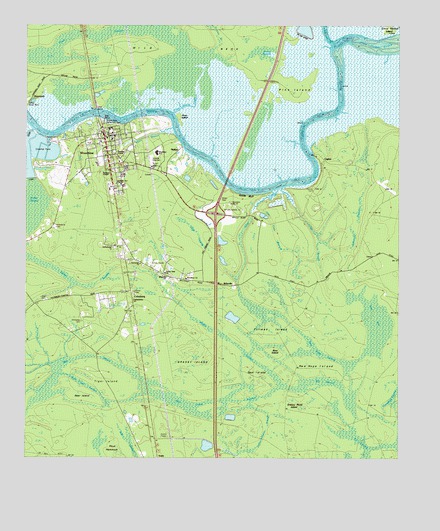
Woodbine, GA USGS Topographic Map
Click on map above to begin viewing in our Map Viewer.

This topographic map contains these locations and features:
Feature Name Type Latitude Longitude GNIS ID View Map
Balls BranchSwampN30.8802°W81.7148°310767View Map
Bear BaySwampN30.9141°W81.6318°325813View Map
Bear IslandIslandN30.8941°W81.7312°310944View Map
Bear IslandIslandN30.9058°W81.6665°325811View Map
Bible ChurchChurchN30.9594°W81.7076°325824View Map
BillyvillePopulated PlaceN30.9255°W81.6823°326185View Map
Bunche High School (historical)SchoolN30.9538°W81.7173°312032View Map
Camden CountyCivilN30.9225°W81.6364°1671316View Map
Camden County CourthouseBuildingN30.9683°W81.7204°1671317View Map
Camden County Fire - Rescue Station 11BuildingN30.9643°W81.7225°2603555View Map
Camden County JailBuildingN30.9674°W81.7212°2734129View Map
Camden County Sheriff's DepartmentBuildingN30.9683°W81.7203°2733706View Map
Camden Street ChurchChurchN30.9541°W81.7198°325822View Map
Cane SwampSwampN30.9016°W81.6376°312292View Map
CeylonPopulated PlaceN30.9616°W81.6507°331370View Map
Ceylon CemeteryCemeteryN30.9533°W81.6537°312536View Map
City of WoodbineCivilN30.9595°W81.7175°2405778View Map
Clay BranchStreamN30.9533°W81.6648°312700View Map
Cole CemeteryCemeteryN30.9208°W81.7434°325814View Map
ColesburgPopulated PlaceN30.9236°W81.7162°355239View Map
Crow Harbor IslandIslandN31.0000°W81.6290°312743View Map
Crow Harbor ReachChannelN30.9936°W81.6329°313184View Map
Dunn BranchStreamN30.9708°W81.7009°313729View Map
Enterprise ChurchChurchN30.9316°W81.7112°355703View Map
Exit 4CrossingN30.9461°W81.6862°1671340View Map
Five Cent BranchStreamN30.9472°W81.6734°325819View Map
Forest View ChurchChurchN30.9286°W81.7037°325816View Map
Gap SwampSwampN30.9407°W81.6940°325818View Map
Gatehouse Plantation (historical)LocaleN30.9544°W81.6518°1671347View Map
Gethsemane ChurchChurchN30.9211°W81.7137°314574View Map
Grassy IslandIslandN30.9030°W81.6934°314785View Map
Grassy Pond IslandIslandN30.8900°W81.6584°314788View Map
Green CemeteryCemeteryN30.9497°W81.6848°325821View Map
HalifaxPopulated PlaceN30.9650°W81.6982°331897View Map
Hamilton ChapelChurchN30.9633°W81.7212°325823View Map
Honey SwampSwampN30.9916°W81.6706°315615View Map
Kenneth McCarthy BridgeBridgeN30.9841°W81.6687°1671368View Map
Kit SwampSwampN30.8808°W81.6387°325812View Map
Lang CreekStreamN30.9533°W81.6657°316628View Map
Madison ChapelChurchN30.9572°W81.7218°317592View Map
Magnolia ChurchChurchN30.9275°W81.7032°325817View Map
Miller CreekStreamN30.9750°W81.7215°318260View Map
Monkey Island CreekStreamN30.9702°W81.7473°318394View Map
New Hope IslandIslandN30.9027°W81.6532°319445View Map
New Hope SwampSwampN30.9075°W81.6529°319448View Map
Nobles BranchStreamN30.9925°W81.6873°319612View Map
Pine IslandIslandN30.9822°W81.6609°320729View Map
Piney IslandIslandN30.9736°W81.6987°320728View Map
Piney Island CreekStreamN30.9752°W81.7007°320731View Map
Plantation PointPopulated PlaceN30.9455°W81.7409°1671409View Map
Refuge (historical)Populated PlaceN30.9891°W81.7298°334831View Map
Rose Creek SwampSwampN30.8920°W81.6987°321903View Map
RunnymeadePopulated PlaceN30.9608°W81.7098°1671417View Map
Satilla BluffCliffN30.9516°W81.6784°322571View Map
Satilla River Waterfront ParkParkN30.9725°W81.7240°1796318View Map
Simmons BranchStreamN30.9752°W81.6448°325820View Map
Spur IslandIslandN30.8986°W81.6720°323487View Map
Tiger BranchSwampN30.9044°W81.7318°324165View Map
Tiger IslandIslandN30.8988°W81.7221°324172View Map
Tillman IslandIslandN30.9113°W81.6654°324179View Map
Walker SwampSwampN30.9216°W81.7007°324785View Map
Walker Swamp IslandIslandN30.9280°W81.7123°334837View Map
WCGA-AM (Woodbine)TowerN30.9319°W81.7084°352598View Map
Whitaker CemeteryCemeteryN30.9149°W81.7312°1796321View Map
White Oak CreekStreamN30.9950°W81.6473°326143View Map
Wild NeckCapeN30.9886°W81.6943°325825View Map
WoodbinePopulated PlaceN30.9638°W81.7226°325526View Map
Woodbine CemeteryCemeteryN30.9422°W81.7404°325527View Map
Woodbine ChurchChurchN30.9269°W81.6962°325815View Map
Woodbine City HallBuildingN30.9681°W81.7240°2502441View Map
Woodbine DivisionCivilN30.9960°W81.6827°1936653View Map
Woodbine Elementary SchoolSchoolN30.9634°W81.7063°1671435View Map
Woodbine Plantation (historical)LocaleN30.9655°W81.7373°1671436View Map
Woodbine Police DepartmentBuildingN30.9680°W81.7240°2733624View Map
Woodbine Post OfficePost OfficeN30.9699°W81.7246°2502498View Map
Woodbine SchoolSchoolN30.9633°W81.7057°1796319View Map
Woodbine Water Pollution Control PlantLocaleN30.9607°W81.7074°2502471View Map

Note: Coordinates in the location and feature list above are referenced to NAD83 datum.


Copyright (C) 2008-2024 Ryan Niemi / Sunset Dynamics ... All Rights Reserved