TopoQuest Logo
Do you find TopoQuest useful?
Help keep TopoQuest running and adding new maps/features by donating!
Bitcoin:  19c7KJd3qBynnjoSw5npx9KScwjBe4ifkT
Litecoin:  LXs6TkuXGGXo1vDsWCkWVdjQX94eUKd6ui
Home View Maps Find Maps Find Places Resources & Links


Wood Lake, Minnesota Topographic Map

USGS Map Title: Wood Lake, MN
USGS Map MRC: 44095F5
DRG (GeoTIFF) Download: o44095f5.tif


Neighboring USGS Topographic Map Quads:


  Hazel Run, MN  
44095G6
 

  Granite Falls, MN  
44095G5
 

  Minnesota Falls, MN  
44095G4
 

  Wood Lake NW, MN  
44095F6
 

  Wood Lake, MN  
44095F5
 

  Lone Tree Lake, MN  
44095F4
 

  Cottonwood, MN  
44095E6
 

  School Grove Lake, MN  
44095E5
 

  Echo, MN  
44095E4


Map MRC Location:

N45°
W96°
N45°
W95°
H8 H7 H6 H5 H4 H3 H2 H1
G8 G7 G6 G5 G4 G3 G2 G1
F8 F7 F6 F5 F4 F3 F2 F1
E8 E7 E6 E5 E4 E3 E2 E1
D8 D7 D6 D5 D4 D3 D2 D1
C8 C7 C6 C5 C4 C3 C2 C1
B8 B7 B6 B5 B4 B3 B2 B1
A8 A7 A6 A5 A4 A3 A2 A1
N44°
W96°
N44°
W95°

Wood Lake, MN USGS 1:24K Topographic Map Preview:
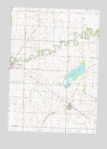
Wood Lake, MN USGS Topographic Map
Click on map above to begin viewing in our Map Viewer.

This topographic map contains these locations and features:
Feature Name Type Latitude Longitude GNIS ID View Map
City of Hanley FallsCivilN44.6918°W95.6194°2394285View Map
City of Wood LakeCivilN44.6513°W95.5358°2397362View Map
County Ditch Number FortynineCanalN44.7136°W95.5920°642139View Map
County Ditch Number FortyoneCanalN44.6847°W95.5914°642075View Map
County Ditch Number FourteenCanalN44.7216°W95.6047°641676View Map
County Ditch Number ThirtyoneCanalN44.6288°W95.5133°641947View Map
East CemeteryCemeteryN44.6886°W95.6142°643059View Map
Hanley FallsLocaleN44.6933°W95.6178°2066261View Map
Hanley FallsPopulated PlaceN44.6927°W95.6220°644628View Map
Hanley FallsLocaleN44.6933°W95.6178°2065624View Map
Hanley Falls Post OfficePost OfficeN44.6928°W95.6217°2066259View Map
Hanley Falls Post OfficePost OfficeN44.6928°W95.6217°2065622View Map
Hanley Falls Volunteer Fire DepartmentBuildingN44.6931°W95.6185°2666532View Map
Judicial Ditch Number TenCanalN44.6413°W95.5695°645781View Map
Lakeview Middle SchoolSchoolN44.6508°W95.5408°2066248View Map
Lakeview Middle SchoolSchoolN44.6508°W95.5408°2065611View Map
LornePopulated PlaceN44.7461°W95.5745°654805View Map
Lorne Post Office (historical)Post OfficeN44.7461°W95.5742°2065578View Map
Lorne Post Office (historical)Post OfficeN44.7461°W95.5742°2066215View Map
Lutheran CemeteryCemeteryN44.6728°W95.5533°2065680View Map
Methodist CemeteryCemeteryN44.6647°W95.5222°2065679View Map
Minnesota's Machinery MuseumBuildingN44.6928°W95.6217°2066260View Map
Minnesota's Machinery MuseumBuildingN44.6928°W95.6217°2065623View Map
Mud LakeLakeN44.6740°W95.5415°648220View Map
Saint John's Lutheran ChurchChurchN44.6528°W95.5381°2065609View Map
Saint John's Lutheran ChurchChurchN44.6528°W95.5381°2066246View Map
Sand Lake BedFlatN44.6338°W95.5253°651166View Map
Township of Wood LakeCivilN44.6736°W95.5436°666041View Map
United Methodist ChurchChurchN44.6528°W95.5381°2065607View Map
United Methodist ChurchChurchN44.6528°W95.5381°2066244View Map
Wood LakeLakeN44.6863°W95.5309°654332View Map
Wood LakePopulated PlaceN44.6527°W95.5383°654335View Map
Wood LakeLocaleN44.6528°W95.5383°2065610View Map
Wood LakeLocaleN44.6528°W95.5383°2066247View Map
Wood Lake Fire DepartmentBuildingN44.6526°W95.5399°2065606View Map
Wood Lake Fire DepartmentBuildingN44.6528°W95.5381°2066243View Map
Wood Lake Post OfficePost OfficeN44.6516°W95.5392°2065608View Map
Wood Lake Post OfficePost OfficeN44.6528°W95.5381°2066245View Map
Yellow Medicine Lutheran ChurchChurchN44.6928°W95.6217°2066258View Map
Yellow Medicine Lutheran ChurchChurchN44.6928°W95.6217°2065621View Map

Note: Coordinates in the location and feature list above are referenced to NAD83 datum.


Copyright (C) 2008-2024 Ryan Niemi / Sunset Dynamics ... All Rights Reserved