TopoQuest Logo
Do you find TopoQuest useful?
Help keep TopoQuest running and adding new maps/features by donating!
Bitcoin:  19c7KJd3qBynnjoSw5npx9KScwjBe4ifkT
Litecoin:  LXs6TkuXGGXo1vDsWCkWVdjQX94eUKd6ui
Home View Maps Find Maps Find Places Resources & Links


Wolf Island, Missouri Topographic Map

USGS Map Title: Wolf Island, MO
USGS Map MRC: 36089F2
DRG (GeoTIFF) Download: o36089f2.tif


Neighboring USGS Topographic Map Quads:


  Anniston, MO  
36089G3
 

  Wickliffe SW, MO  
36089G2
 

  Arlington, KY  
36089G1
 

  Bayouville, MO  
36089F3
 

  Wolf Island, MO  
36089F2
 

  Oakton, KY  
36089F1
 

  Bondurant, KY  
36089E3
 

  Hickman, KY  
36089E2
 

  Cayce, KY  
36089E1


Map MRC Location:

N37°
W90°
N37°
W89°
H8 H7 H6 H5 H4 H3 H2 H1
G8 G7 G6 G5 G4 G3 G2 G1
F8 F7 F6 F5 F4 F3 F2 F1
E8 E7 E6 E5 E4 E3 E2 E1
D8 D7 D6 D5 D4 D3 D2 D1
C8 C7 C6 C5 C4 C3 C2 C1
B8 B7 B6 B5 B4 B3 B2 B1
A8 A7 A6 A5 A4 A3 A2 A1
N36°
W90°
N36°
W89°

Wolf Island, MO USGS 1:24K Topographic Map Preview:
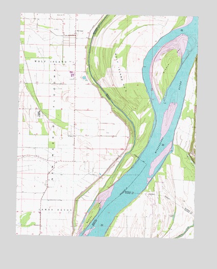
Wolf Island, MO USGS Topographic Map
Click on map above to begin viewing in our Map Viewer.

This topographic map contains these locations and features:
Feature Name Type Latitude Longitude GNIS ID View Map
Barnes CemeteryCemeteryN36.7492°W89.2245°713667View Map
Beckwith BendBendN36.6287°W89.1995°739572View Map
Chalk BluffCliffN36.7273°W89.1253°489310View Map
Grey SchoolSchoolN36.6964°W89.2359°741760View Map
Ivie CemeteryCemeteryN36.7412°W89.2231°720187View Map
Lateral Number 7CanalN36.7103°W89.2409°755455View Map
Lee CemeteryCemeteryN36.7064°W89.2187°741759View Map
Little Eagle Pond (historical)LakeN36.6328°W89.2453°739571View Map
Long PondLakeN36.6374°W89.1392°497129View Map
Macedonia ChurchChurchN36.6309°W89.2323°721717View Map
Medley BarBarN36.6398°W89.1942°722195View Map
Medley LandingLocaleN36.6742°W89.1734°741761View Map
Medley School (historical)SchoolN36.6714°W89.1787°746840View Map
Middle BarBarN36.7253°W89.1431°498094View Map
Moore IslandIslandN36.6623°W89.1765°737963View Map
Mount Zion ChurchChurchN36.6812°W89.2103°722944View Map
Muscovalley Post LightBuildingN36.7167°W89.1334°517045View Map
Pinhook School (historical)SchoolN36.7109°W89.2453°741758View Map
Sassafras Ridge Church (historical)ChurchN36.7376°W89.2106°741757View Map
Sassafras Ridge SchoolSchoolN36.7473°W89.2209°741754View Map
Sassafras Ridge SchoolSchoolN36.7376°W89.2106°741756View Map
Three PondsLakeN36.6685°W89.1276°505238View Map
Three Ponds BluffCliffN36.6695°W89.1276°505239View Map
Towosahgy State ParkParkN36.6934°W89.2356°727748View Map
Walnut Grove (historical)Populated PlaceN36.6363°W89.1587°2743925View Map
Wolf IslandPopulated PlaceN36.7392°W89.2103°729069View Map
Wolf Island CemeteryCemeteryN36.7423°W89.2287°741753View Map
Wolf Island Church (historical)ChurchN36.7423°W89.2115°741755View Map
Wolf Island Church (historical)ChurchN36.7103°W89.2328°746839View Map
Wolf Island Number 5IslandN36.7223°W89.1753°517309View Map
Wolf Island School (historical)SchoolN36.7103°W89.2328°2120855View Map
Wolf Island School (historical)SchoolN36.7212°W89.2151°746838View Map

Note: Coordinates in the location and feature list above are referenced to NAD83 datum.


Copyright (C) 2008-2024 Ryan Niemi / Sunset Dynamics ... All Rights Reserved