TopoQuest Logo
Do you find TopoQuest useful?
Help keep TopoQuest running and adding new maps/features by donating!
Bitcoin:  19c7KJd3qBynnjoSw5npx9KScwjBe4ifkT
Litecoin:  LXs6TkuXGGXo1vDsWCkWVdjQX94eUKd6ui
Home View Maps Find Maps Find Places Resources & Links


Winsted, Minnesota Topographic Map

USGS Map Title: Winsted, MN
USGS Map MRC: 44094H1
DRG (GeoTIFF) Download: o44094h1.tif


Neighboring USGS Topographic Map Quads:


  Cokato, MN  
45094A2
 

  Howard Lake, MN  
45094A1
 

  Waverly, MN  
45093A8
 

  Silver Lake, MN  
44094H2
 

  Winsted, MN  
44094H1
 

  Mayer, MN  
44093H8
 

  Glencoe, MN  
44094G2
 

  Plato, MN  
44094G1
 

  Norwood, MN  
44093G8


Map MRC Location:

N45°
W95°
N45°
W94°
H8 H7 H6 H5 H4 H3 H2 H1
G8 G7 G6 G5 G4 G3 G2 G1
F8 F7 F6 F5 F4 F3 F2 F1
E8 E7 E6 E5 E4 E3 E2 E1
D8 D7 D6 D5 D4 D3 D2 D1
C8 C7 C6 C5 C4 C3 C2 C1
B8 B7 B6 B5 B4 B3 B2 B1
A8 A7 A6 A5 A4 A3 A2 A1
N44°
W95°
N44°
W94°

Winsted, MN USGS 1:24K Topographic Map Preview:
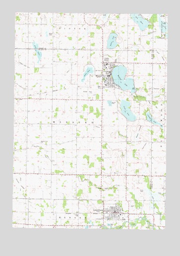
Winsted, MN USGS Topographic Map
Click on map above to begin viewing in our Map Viewer.

This topographic map contains these locations and features:
Feature Name Type Latitude Longitude GNIS ID View Map
Bethel Lutheran ChurchChurchN44.8847°W94.0486°2065236View Map
Butler LakeLakeN44.9835°W94.0456°640700View Map
Campbell LakeLakeN44.9386°W94.0124°640850View Map
City of Lester PrairieCivilN44.8828°W94.0379°2395687View Map
City of WinstedCivilN44.9587°W94.0501°2397351View Map
Cloustier LakebedFlatN44.9000°W94.1197°1815284View Map
Coon LakesLakeN44.9765°W94.1055°641477View Map
Country AcresPopulated PlaceN44.9733°W94.0525°2065192View Map
County Ditch Number Ten ACanalN44.9094°W94.0864°1815297View Map
County Park Number ThreeParkN44.9516°W94.0225°1815289View Map
Dog LakeLakeN44.9930°W94.0039°642871View Map
Evangelical United Church of ChristChurchN44.8861°W94.0392°2065234View Map
Grass LakeLakeN44.9656°W94.0652°644365View Map
Hainlin ParkParkN44.9608°W94.0522°644569View Map
Higgins LakebedFlatN44.9236°W94.0175°1815285View Map
Holy Trinity Catholic ChurchChurchN44.9650°W94.0467°2065204View Map
Holy Trinity CemeteryCemeteryN44.9670°W94.0517°1815290View Map
Holy Trinity Elementary SchoolSchoolN44.9658°W94.0472°2065202View Map
Holy Trinity High SchoolSchoolN44.9656°W94.0469°2065201View Map
Johnson County ParkParkN44.9902°W94.0052°1815359View Map
Lake MaryLakeN44.9961°W94.0235°647599View Map
Lester PrairieLocaleN44.8844°W94.0422°2065233View Map
Lester PrairiePopulated PlaceN44.8839°W94.0416°646615View Map
Lester Prairie City CemeteryCemeteryN44.8811°W94.0518°2065280View Map
Lester Prairie City HallBuildingN44.8858°W94.0419°2065230View Map
Lester Prairie Fire Department and First RespondersBuildingN44.8855°W94.0366°2065231View Map
Lester Prairie Medical ClinicHospitalN44.8856°W94.0425°2065238View Map
Lester Prairie Police DepartmentBuildingN44.8857°W94.0418°2065228View Map
Lester Prairie Post OfficePost OfficeN44.8857°W94.0418°2065229View Map
Lester Prairie Public SchoolSchoolN44.8872°W94.0436°2065239View Map
Maple LakeSwampN44.9868°W94.0991°647488View Map
Nylanda ChurchChurchN44.9897°W94.0127°648770View Map
Nylunda CemeteryCemeteryN44.9893°W94.0128°2067365View Map
Old Holy Trinity CemeteryCemeteryN44.9250°W94.1030°1815288View Map
Otter CreekStreamN44.8819°W94.0166°649045View Map
Parkview Mobile Home ParkPopulated PlaceN44.8825°W94.0356°2065232View Map
Reich LakeSwampN44.8944°W94.0100°1815281View Map
Ridgeview Ambulance Service Lester PrairieBuildingN44.8855°W94.0367°2721360View Map
Ridgeview Ambulance Service WinstedBuildingN44.9593°W94.0525°2721359View Map
Ridgeview Winsted ClinicHospitalN44.9706°W94.0494°2065200View Map
Roach LakebedFlatN44.9333°W94.0225°1815286View Map
Saint John's Lutheran ChurchChurchN44.9681°W94.0467°2065205View Map
Saint Marys Care CenterHospitalN44.9706°W94.0494°2065199View Map
Saint Paul CemeteryCemeteryN44.8806°W94.0521°1815282View Map
Saint Paul's Lutheran ChurchChurchN44.8869°W94.0403°2065237View Map
Saint Peter CemeteryCemeteryN44.8837°W94.0730°1815283View Map
Saint Peter Lutheran ChurchChurchN44.8817°W94.0486°2065235View Map
Saint Peter SchoolSchoolN44.8841°W94.0722°651012View Map
School Number 988SchoolN44.9575°W94.1041°651769View Map
Serenity Airport (historical)AirportN44.9168°W94.0919°2676852View Map
Shadowbrooke Golf CourseLocaleN44.9069°W94.0194°2065240View Map
South LakeLakeN44.9436°W94.0326°652323View Map
Swan LakebedFlatN44.9764°W94.0058°1815291View Map
Swedish CemeteryCemeteryN44.9864°W94.0029°1815292View Map
Township of WinstedCivilN44.9341°W94.0746°666028View Map
Winfield Police DepartmentBuildingN44.9650°W94.0461°2065194View Map
Winfield Public LibraryBuildingN44.9639°W94.0472°2065197View Map
WinstedPopulated PlaceN44.9639°W94.0475°654275View Map
Winsted City HallBuildingN44.9639°W94.0472°2065195View Map
Winsted Elementary SchoolSchoolN44.9686°W94.0497°2065203View Map
Winsted Fire DepartmentBuildingN44.9593°W94.0526°2065193View Map
Winsted LakeReservoirN44.9550°W94.0252°1776164View Map
Winsted LakeLakeN44.9622°W94.0366°654276View Map
Winsted Lake DamDamN44.9550°W94.0252°1776163View Map
Winsted Medical ClinicHospitalN44.9697°W94.0500°2065198View Map
Winsted Municipal AirportAirportN44.9542°W94.0719°660481View Map
Winsted Police DepartmentBuildingN44.9654°W94.0463°2758544View Map
Winsted Post OfficePost OfficeN44.9639°W94.0473°2065196View Map

Note: Coordinates in the location and feature list above are referenced to NAD83 datum.


Copyright (C) 2008-2024 Ryan Niemi / Sunset Dynamics ... All Rights Reserved