TopoQuest Logo
Do you find TopoQuest useful?
Help keep TopoQuest running and adding new maps/features by donating!
Bitcoin:  19c7KJd3qBynnjoSw5npx9KScwjBe4ifkT
Litecoin:  LXs6TkuXGGXo1vDsWCkWVdjQX94eUKd6ui
Home View Maps Find Maps Find Places Resources & Links


Winslow, Arizona Topographic Map

USGS Map Title: Winslow, AZ
USGS Map MRC: 35110A6
DRG (GeoTIFF) Download: o35110a6.tif


Neighboring USGS Topographic Map Quads:


  Tucker Mesa NE, AZ  
35110B7
 

  Winslow NW, AZ  
35110B6
 

  Winslow NE, AZ  
35110B5
 

  Tucker Mesa, AZ  
35110A7
 

  Winslow, AZ  
35110A6
 

  Rincon Ranch, AZ  
35110A5
 

  Rock Station, AZ  
34110H7
 

  Clear Creek Reservoir, AZ  
34110H6
 

  Hibbard, AZ  
34110H5


Map MRC Location:

N36°
W111°
N36°
W110°
H8 H7 H6 H5 H4 H3 H2 H1
G8 G7 G6 G5 G4 G3 G2 G1
F8 F7 F6 F5 F4 F3 F2 F1
E8 E7 E6 E5 E4 E3 E2 E1
D8 D7 D6 D5 D4 D3 D2 D1
C8 C7 C6 C5 C4 C3 C2 C1
B8 B7 B6 B5 B4 B3 B2 B1
A8 A7 A6 A5 A4 A3 A2 A1
N35°
W111°
N35°
W110°

Winslow, AZ USGS 1:24K Topographic Map Preview:
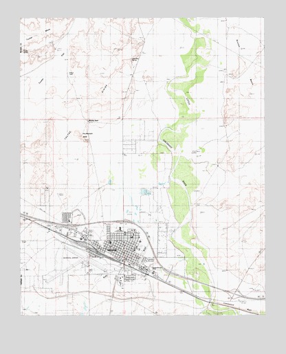
Winslow, AZ USGS Topographic Map
Click on map above to begin viewing in our Map Viewer.

This topographic map contains these locations and features:
Feature Name Type Latitude Longitude GNIS ID View Map
Bonnie Brennan Elementary SchoolSchoolN35.0396°W110.7253°23324View Map
Brigham City (historical)Populated PlaceN35.0417°W110.6507°1828925View Map
Bushman AcresPopulated PlaceN35.0242°W110.6801°2290View Map
City of WinslowCivilN35.0252°W110.7098°2412286View Map
City of Winslow Wastewater Treatment PlantLocaleN35.0542°W110.6777°2669618View Map
Cottonwood WashStreamN35.0028°W110.6549°3402View Map
Cottonwood Wash BridgeBridgeN35.0056°W110.6535°23348View Map
Desert View Baptist ChurchChurchN35.0392°W110.7245°2670866View Map
First Assembly of GodChurchN35.0249°W110.6915°2670927View Map
First Baptist Church of WinslowChurchN35.0261°W110.6981°2670963View Map
First Christian ChurchChurchN35.0265°W110.6985°2670968View Map
First United Methodist ChurchChurchN35.0338°W110.6928°2671020View Map
Hopi-Winslow DistrictCivilN35.0347°W110.7484°2418965View Map
Jefferson Elementary SchoolSchoolN35.0331°W110.6937°23384View Map
KINO-AM (Winslow)TowerN35.0375°W110.7174°43490View Map
KRIM-FM (Winslow)TowerN35.0511°W110.7385°43494View Map
Lincoln Elementary SchoolSchoolN35.0281°W110.6971°23397View Map
Little Colorado Medical CenterHospitalN35.0358°W110.6923°23462View Map
Navajo County Sheriff's Office WinslowBuildingN35.0228°W110.6976°2751601View Map
North Park Plaza Shopping CenterLocaleN35.0409°W110.6812°23408View Map
Northern Arizona Academy For Career Development WinslowSchoolN35.0184°W110.7163°2543637View Map
Northland Pioneer College Little Colorado CampusSchoolN35.0208°W110.6838°2672181View Map
Northland Pioneer College Little Colorado Campus Blunk Health Sciences CenterSchoolN35.0203°W110.6836°2672180View Map
Northland Pioneer College Little Colorado Campus Ruby Hall BuildingSchoolN35.0213°W110.6832°2672182View Map
Roosevelt Elementary SchoolSchoolN35.0167°W110.6974°23425View Map
Saint Joseph's ChurchChurchN35.0243°W110.6999°2671307View Map
Saint Joseph's ChurchChurchN35.0349°W110.6975°2671308View Map
Saint Josephs Catholic SchoolSchoolN35.0353°W110.6965°23428View Map
Saint Pauls Episcopal ChurchChurchN35.0357°W110.7007°2671332View Map
Sundown Mobile Home ParkPopulated PlaceN35.0354°W110.7301°2670409View Map
Sunset CemeteryCemeteryN35.0468°W110.6600°1851964View Map
Sunset City (historical)Populated PlaceN35.0445°W110.6535°1851963View Map
Sunset CrossingParkN35.0148°W110.6791°2651791View Map
Sunset Crossing (historical)Populated PlaceN35.0143°W110.6536°2651792View Map
Tucker SpringSpringN35.1111°W110.7487°12808View Map
Warren Avenue Church of ChristChurchN35.0277°W110.6965°2671449View Map
Washington Elementary SchoolSchoolN35.0281°W110.6977°23448View Map
West WinslowPopulated PlaceN35.0403°W110.7424°25327View Map
Whipple Memorial ParkCemeteryN35.0247°W110.6749°23451View Map
WinslowPopulated PlaceN35.0242°W110.6974°13930View Map
Winslow City HallBuildingN35.0222°W110.6979°23457View Map
Winslow City ParkParkN35.0270°W110.6890°23458View Map
Winslow Civic CenterBuildingN35.0181°W110.7162°23459View Map
Winslow Fire DepartmentBuildingN35.0206°W110.6889°2672434View Map
Winslow High SchoolSchoolN35.0281°W110.6889°23460View Map
Winslow Indian Health Care CenterBuildingN35.0337°W110.7146°2670310View Map
Winslow Junior High SchoolSchoolN35.0310°W110.6893°23461View Map
Winslow Police DepartmentBuildingN35.0275°W110.7043°2672317View Map
Winslow Post OfficePost OfficeN35.0237°W110.6968°44976View Map
Winslow Public LibraryBuildingN35.0339°W110.6985°23464View Map
Winslow Railroad StationBuildingN35.0203°W110.6937°23465View Map
Winslow Residential HallSchoolN35.0307°W110.7047°2543717View Map
Winslow-Lindbergh Regional AirportAirportN35.0224°W110.7161°23463View Map
Zion Baptist ChurchChurchN35.0242°W110.6914°2671489View Map

Note: Coordinates in the location and feature list above are referenced to NAD83 datum.


Copyright (C) 2008-2024 Ryan Niemi / Sunset Dynamics ... All Rights Reserved