TopoQuest Logo
Do you find TopoQuest useful?
Help keep TopoQuest running and adding new maps/features by donating!
Bitcoin:  19c7KJd3qBynnjoSw5npx9KScwjBe4ifkT
Litecoin:  LXs6TkuXGGXo1vDsWCkWVdjQX94eUKd6ui
Home View Maps Find Maps Find Places Resources & Links


Winfield, Missouri Topographic Map

USGS Map Title: Winfield, MO
USGS Map MRC: 38090H6
DRG (GeoTIFF) Download: o38090h6.tif


Neighboring USGS Topographic Map Quads:


  Luckett Ridge, MO  
39090A7
 

  Foley, MO  
39090A6
 

  Nutwood, IL  
39090A5
 

  Maryknoll, MO  
38090H7
 

  Winfield, MO  
38090H6
 

  Brussels, IL  
38090H5
 

  Wentzville, MO  
38090G7
 

  O'Fallon, MO  
38090G6
 

  Kampville, MO  
38090G5


Map MRC Location:

N39°
W91°
N39°
W90°
H8 H7 H6 H5 H4 H3 H2 H1
G8 G7 G6 G5 G4 G3 G2 G1
F8 F7 F6 F5 F4 F3 F2 F1
E8 E7 E6 E5 E4 E3 E2 E1
D8 D7 D6 D5 D4 D3 D2 D1
C8 C7 C6 C5 C4 C3 C2 C1
B8 B7 B6 B5 B4 B3 B2 B1
A8 A7 A6 A5 A4 A3 A2 A1
N38°
W91°
N38°
W90°

Winfield, MO USGS 1:24K Topographic Map Preview:
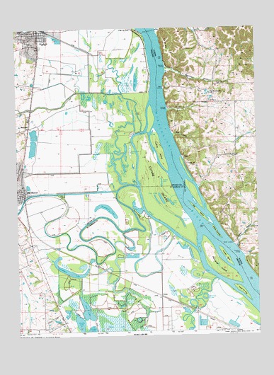
Winfield, MO USGS Topographic Map
Click on map above to begin viewing in our Map Viewer.

This topographic map contains these locations and features:
Feature Name Type Latitude Longitude GNIS ID View Map
Argent SloughStreamN38.9348°W90.6910°713380View Map
Barrett LakeLakeN38.8876°W90.6530°755726View Map
Beech LandingLocaleN38.9737°W90.6726°422448View Map
BeechvillePopulated PlaceN38.9714°W90.6476°422449View Map
Bernard LakeLakeN38.9186°W90.6638°755758View Map
Bobs CreekStreamN38.9562°W90.6846°735524View Map
Bond HollowValleyN38.9548°W90.6682°404674View Map
BrevatorPopulated PlaceN38.9581°W90.7432°740690View Map
Brush LakeLakeN38.9413°W90.6940°714874View Map
Cache HollowValleyN38.9097°W90.6371°405330View Map
Camp Eter LakeLakeN38.9484°W90.6907°715264View Map
Cap Au GrisRidgeN38.9914°W90.6721°405570View Map
Cap au GrisPopulated PlaceN38.9989°W90.6918°735549View Map
City of Old MonroeCivilN38.9379°W90.7470°2396052View Map
City of WinfieldCivilN38.9944°W90.7438°2397345View Map
Clear LakeLakeN38.8862°W90.7218°755900View Map
Clear LakeLakeN38.9854°W90.6922°735560View Map
Cuivre CanalCanalN38.9314°W90.7137°735450View Map
Cuivre IslandIslandN38.9348°W90.6771°716583View Map
Cuivre Junction (historical)LocaleN38.9195°W90.7437°758134View Map
Cuivre RiverStreamN38.9334°W90.6871°755957View Map
Cuivre SloughStreamN38.8851°W90.6285°755958View Map
Dark LakeLakeN38.9815°W90.6889°716672View Map
Dogtown HollowValleyN38.9816°W90.6721°407284View Map
Dogtown LandingLocaleN38.9831°W90.6712°422632View Map
Dolbow (historical)LocaleN38.9014°W90.7087°757212View Map
FirmaPopulated PlaceN38.8892°W90.6760°756052View Map
Fish LakeLakeN38.9763°W90.6874°717940View Map
Fish SloughLakeN38.8910°W90.6970°756053View Map
Fort Cape au Gris (historical)MilitaryN38.9958°W90.6844°754208View Map
Hastings LandingLocaleN38.9656°W90.6710°422790View Map
Hat IslandIslandN38.9237°W90.6562°409918View Map
Hayden School (historical)SchoolN38.9012°W90.7487°756977View Map
Horseshoe LakeLakeN38.9246°W90.7035°735655View Map
Horseshoe LakeLakeN38.8987°W90.7228°756193View Map
Indian HillSummitN38.9423°W90.6579°410860View Map
Ingle CemeteryCemeteryN38.9775°W90.6448°410896View Map
Island Number 508IslandN38.8912°W90.6329°756217View Map
Johnson IslandIslandN38.9417°W90.6626°422205View Map
Lharky LakeLakeN38.8782°W90.7181°756297View Map
Maple LakeLakeN38.8764°W90.6987°756344View Map
Maple School (historical)SchoolN38.8992°W90.6760°756978View Map
Martin LandingLocaleN38.9103°W90.6382°422945View Map
Martin TowheadIslandN38.9151°W90.6468°413077View Map
McLean CreekStreamN38.9726°W90.7107°735718View Map
Minesinger CemeteryCemeteryN38.9478°W90.6360°413651View Map
Mud LakeLakeN38.8834°W90.7145°756431View Map
Nichols School (historical)SchoolN38.9898°W90.6504°414512View Map
Old MonroePopulated PlaceN38.9317°W90.7468°735766View Map
Old Monroe Fire Protection District Station 1BuildingN38.9316°W90.7477°2621438View Map
Old Monroe MoundsLocaleN38.9328°W90.7462°735449View Map
Old Monroe Post OfficePost OfficeN38.9298°W90.7469°2783069View Map
Peruque CreekStreamN38.8962°W90.6465°756521View Map
Peruque IslandIslandN38.9006°W90.6454°756522View Map
Poppleton LandingLocaleN38.9070°W90.6337°423078View Map
RichfieldLocaleN38.8789°W90.7262°758133View Map
Sunset LandingLocaleN38.9459°W90.6637°423223View Map
Sweden IslandIslandN38.9056°W90.6418°756777View Map
The Cave InBasinN38.9650°W90.6654°419628View Map
Turkey IslandIslandN38.9481°W90.6748°727874View Map
Turkey LakeLakeN38.9352°W90.6746°727877View Map
Twin LakesLakeN38.9287°W90.6747°756812View Map
West Point FerryCrossingN38.9964°W90.6798°420892View Map
West Point FerryCrossingN38.9967°W90.6798°728610View Map
Western School (historical)SchoolN38.9481°W90.6362°1748337View Map
Westhoff DamDamN38.9801°W90.7485°761803View Map
Westhoff LakeReservoirN38.9803°W90.7490°761804View Map
WinfieldPopulated PlaceN38.9973°W90.7385°728996View Map
Winfield - Foley Fire Protection District Station 1BuildingN38.9955°W90.7369°2620789View Map
Winfield CemeteryCemeteryN38.9975°W90.7405°2585206View Map
Winfield Intermediate SchoolSchoolN38.9965°W90.7446°2651606View Map
Winfield Middle SchoolSchoolN38.9956°W90.7469°2651604View Map
Winfield Police DepartmentBuildingN38.9925°W90.7457°2752317View Map
Winfield Post OfficePost OfficeN38.9970°W90.7403°2782917View Map
Winfield Primary SchoolSchoolN38.9942°W90.7467°2651605View Map

Note: Coordinates in the location and feature list above are referenced to NAD83 datum.


Copyright (C) 2008-2024 Ryan Niemi / Sunset Dynamics ... All Rights Reserved