TopoQuest Logo
Do you find TopoQuest useful?
Help keep TopoQuest running and adding new maps/features by donating!
Bitcoin:  19c7KJd3qBynnjoSw5npx9KScwjBe4ifkT
Litecoin:  LXs6TkuXGGXo1vDsWCkWVdjQX94eUKd6ui
Home View Maps Find Maps Find Places Resources & Links


Winchester, Arkansas Topographic Map

USGS Map Title: Winchester, AR
USGS Map MRC: 33091G4
DRG (GeoTIFF) Download: o33091g4.tif


Neighboring USGS Topographic Map Quads:


  Gould, AR  
33091H5
 

  Dumas, AR  
33091H4
 

  Watson, AR  
33091H3
 

  Gourd, AR  
33091G5
 

  Winchester, AR  
33091G4
 

  Kelso, AR  
33091G3
 

  Selma, AR  
33091F5
 

  McGehee North, AR  
33091F4
 

  McArthur, AR  
33091F3


Map MRC Location:

N34°
W92°
N34°
W91°
H8 H7 H6 H5 H4 H3 H2 H1
G8 G7 G6 G5 G4 G3 G2 G1
F8 F7 F6 F5 F4 F3 F2 F1
E8 E7 E6 E5 E4 E3 E2 E1
D8 D7 D6 D5 D4 D3 D2 D1
C8 C7 C6 C5 C4 C3 C2 C1
B8 B7 B6 B5 B4 B3 B2 B1
A8 A7 A6 A5 A4 A3 A2 A1
N33°
W92°
N33°
W91°

Winchester, AR USGS 1:24K Topographic Map Preview:
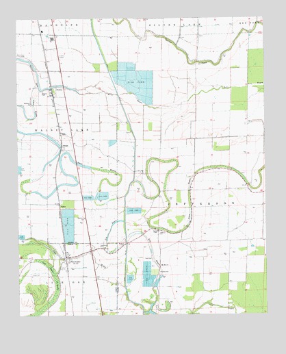
Winchester, AR USGS Topographic Map
Click on map above to begin viewing in our Map Viewer.

This topographic map contains these locations and features:
Feature Name Type Latitude Longitude GNIS ID View Map
Amos BayouLakeN33.8158°W91.4829°45855View Map
Bethlehem ChurchChurchN33.8395°W91.4929°46470View Map
Canal Number 19CanalN33.8490°W91.4518°81989View Map
Claiborne ChapelChurchN33.8445°W91.4871°47793View Map
Coon BayouGutN33.7529°W91.3971°47991View Map
Coon Bayou BrakeSwampN33.7558°W91.4842°47993View Map
Delta Memorial HospitalHospitalN33.8733°W91.4804°63800View Map
Dixon CemeteryCemeteryN33.7670°W91.4929°48535View Map
Dry BayouLakeN33.7770°W91.4332°48614View Map
Hopedale (historical)Populated PlaceN33.7918°W91.4662°63826View Map
Hopedale ChurchChurchN33.7909°W91.4660°50296View Map
Hopkins CemeteryCemeteryN33.7682°W91.4287°50314View Map
Jefferson CemeteryCemeteryN33.7854°W91.4287°50602View Map
Mount Olive ChurchChurchN33.7709°W91.4282°52343View Map
New Light ChurchChurchN33.8098°W91.4365°52716View Map
Newton CemeteryCemeteryN33.7801°W91.4462°52760View Map
Newton ChapelChurchN33.7854°W91.4296°52762View Map
Oak Grove CemeteryCemeteryN33.7790°W91.4587°52882View Map
OmegaPopulated PlaceN33.8215°W91.4776°77919View Map
PickensPopulated PlaceN33.8457°W91.4818°77991View Map
Pickens Airport (historical)AirportN33.8584°W91.4785°63770View Map
Pickens Post OfficePost OfficeN33.8438°W91.4827°2781945View Map
Scott CemeteryCemeteryN33.7740°W91.4326°54638View Map
Town of WinchesterCivilN33.7740°W91.4738°2406896View Map
Township of JeffersonCivilN33.8034°W91.3954°66501View Map
Walnut LakeLakeN33.8584°W91.4983°77318View Map
Walnut Lake CemeteryCemeteryN33.8593°W91.4979°56016View Map
Walnut Lake DamDamN33.8570°W91.4929°80765View Map
Williamson ChapelChurchN33.8265°W91.4751°56406View Map
WinchesterPopulated PlaceN33.7746°W91.4746°56453View Map
Winchester Fire StationBuildingN33.7747°W91.4750°2117326View Map
Winchester Post OfficePost OfficeN33.7752°W91.4727°84788View Map
YukonPopulated PlaceN33.7970°W91.4790°57244View Map

Note: Coordinates in the location and feature list above are referenced to NAD83 datum.


Copyright (C) 2008-2024 Ryan Niemi / Sunset Dynamics ... All Rights Reserved