TopoQuest Logo
Do you find TopoQuest useful?
Help keep TopoQuest running and adding new maps/features by donating!
Bitcoin:  19c7KJd3qBynnjoSw5npx9KScwjBe4ifkT
Litecoin:  LXs6TkuXGGXo1vDsWCkWVdjQX94eUKd6ui
Home View Maps Find Maps Find Places Resources & Links


Willow Ranch, California Topographic Map

USGS Map Title: Willow Ranch, CA
USGS Map MRC: 41120H3
DRG (GeoTIFF) Download: o41120h3.tif


Neighboring USGS Topographic Map Quads:


  West Side, OR  
42120A4
 

  Crane Creek, OR  
42120A3
 

  Crane Mountain, OR  
42120A2
 

  West of Willow Ranch, CA  
41120H4
 

  Willow Ranch, CA  
41120H3
 

  Mount Bidwell, CA  
41120H2
 

  McGinty Point, CA  
41120G4
 

  Sugar Hill, CA  
41120G3
 

  Fort Bidwell, CA  
41120G2


Map MRC Location:

N42°
W121°
N42°
W120°
H8 H7 H6 H5 H4 H3 H2 H1
G8 G7 G6 G5 G4 G3 G2 G1
F8 F7 F6 F5 F4 F3 F2 F1
E8 E7 E6 E5 E4 E3 E2 E1
D8 D7 D6 D5 D4 D3 D2 D1
C8 C7 C6 C5 C4 C3 C2 C1
B8 B7 B6 B5 B4 B3 B2 B1
A8 A7 A6 A5 A4 A3 A2 A1
N41°
W121°
N41°
W120°

Willow Ranch, CA USGS 1:24K Topographic Map Preview:
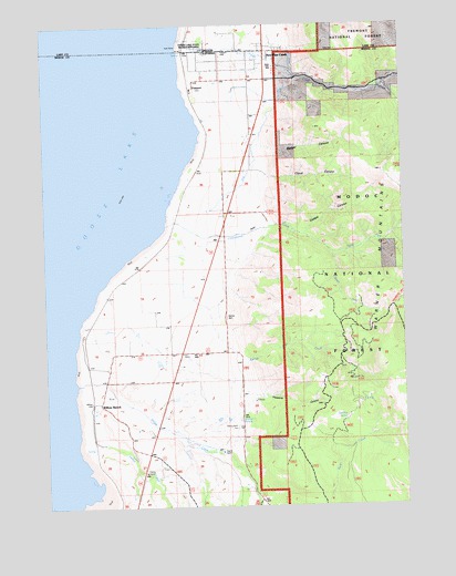
Willow Ranch, CA USGS Topographic Map
Click on map above to begin viewing in our Map Viewer.

This topographic map contains these locations and features:
Feature Name Type Latitude Longitude GNIS ID View Map
Badger CanyonValleyN41.9685°W120.3002°218511View Map
Barnes CreekStreamN41.9295°W120.3248°218684View Map
Cloud CanyonValleyN41.9621°W120.3002°221235View Map
Coalpit CanyonValleyN41.9474°W120.2850°221277View Map
Cottonwood CreekStreamN41.9485°W120.3352°221639View Map
Davidson SpringSpringN41.8973°W120.3088°252601View Map
Del Prat SpringSpringN41.8979°W120.2715°222234View Map
FairportPopulated PlaceN41.9852°W120.3219°252603View Map
Goose Lake Reservoir Boat RampLocaleN41.9932°W120.3297°2700208View Map
Goose Lake State ParkParkN41.9943°W120.3233°1160927View Map
Hogback CreekStreamN41.9832°W120.2594°252602View Map
Lassen CreekStreamN41.8913°W120.3666°226903View Map
New Pine CreekPopulated PlaceN41.9941°W120.2972°1164121View Map
New Pine Creek Census Designated PlaceCensusN41.9873°W120.3010°2583092View Map
New Pine Creek Post OfficePost OfficeN41.9940°W120.2971°1165701View Map
New Pine Creek Rural Fire Protection DistrictBuildingN41.9936°W120.2978°2577040View Map
North Fork Cottonwood CreekStreamN41.9413°W120.2752°229657View Map
Pine CreekStreamN41.9968°W120.3269°1147687View Map
Pleasants CanyonValleyN41.9038°W120.3038°230820View Map
South Fork Cottonwood CreekStreamN41.9410°W120.2747°234990View Map
State Line Elementary SchoolSchoolN41.9879°W120.2994°235402View Map
Willow CreekStreamN41.9068°W120.3669°237898View Map
Willow RanchPopulated PlaceN41.9024°W120.3583°237927View Map
Willow Ranch CemeteryCemeteryN41.8955°W120.3093°237928View Map
Willow Ranch Fire Protection DistrictBuildingN41.9148°W120.3284°2622157View Map

Note: Coordinates in the location and feature list above are referenced to NAD83 datum.


Copyright (C) 2008-2024 Ryan Niemi / Sunset Dynamics ... All Rights Reserved