TopoQuest Logo
Do you find TopoQuest useful?
Help keep TopoQuest running and adding new maps/features by donating!
Bitcoin:  19c7KJd3qBynnjoSw5npx9KScwjBe4ifkT
Litecoin:  LXs6TkuXGGXo1vDsWCkWVdjQX94eUKd6ui
Home View Maps Find Maps Find Places Resources & Links


Williamsburg, West Virginia Topographic Map

USGS Map Title: Williamsburg, WV
USGS Map MRC: 37080H4
DRG (GeoTIFF) Download: o37080h4.tif


Neighboring USGS Topographic Map Quads:


  Duo, WV  
38080A5
 

  Trout, WV  
38080A4
 

  Droop, WV  
38080A3
 

  Cornstalk, WV  
37080H5
 

  Williamsburg, WV  
37080H4
 

  Anthony, WV  
37080H3
 

  Asbury, WV  
37080G5
 

  Lewisburg, WV  
37080G4
 

  White Sulphur Springs, WV  
37080G3


Map MRC Location:

N38°
W81°
N38°
W80°
H8 H7 H6 H5 H4 H3 H2 H1
G8 G7 G6 G5 G4 G3 G2 G1
F8 F7 F6 F5 F4 F3 F2 F1
E8 E7 E6 E5 E4 E3 E2 E1
D8 D7 D6 D5 D4 D3 D2 D1
C8 C7 C6 C5 C4 C3 C2 C1
B8 B7 B6 B5 B4 B3 B2 B1
A8 A7 A6 A5 A4 A3 A2 A1
N37°
W81°
N37°
W80°

Williamsburg, WV USGS 1:24K Topographic Map Preview:
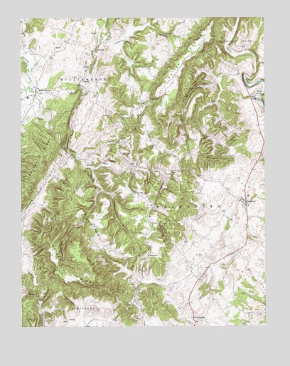
Williamsburg, WV USGS Topographic Map
Click on map above to begin viewing in our Map Viewer.

This topographic map contains these locations and features:
Feature Name Type Latitude Longitude GNIS ID View Map
Asbury Fishing Lake DamDamN37.9518°W80.3998°1559326View Map
Bethel School (historical)SchoolN37.9357°W80.4879°1556245View Map
BrantvillePopulated PlaceN37.9040°W80.4342°1553966View Map
Buckeye CreekStreamN37.9726°W80.4015°1536584View Map
Burns RunStreamN37.9390°W80.4629°1536755View Map
Butler MountainSummitN37.9773°W80.4226°1554038View Map
Carroll HillSummitN37.9135°W80.4329°1554078View Map
Carroll Hill School (historical)SchoolN37.9296°W80.4426°1556259View Map
Castret SpringSpringN37.9785°W80.4664°1557494View Map
Chestnut FlatFlatN37.9085°W80.4556°1537266View Map
Chestnut Flat School (historical)SchoolN37.9029°W80.4434°1556263View Map
ClendenenvillePopulated PlaceN37.8790°W80.4120°1554147View Map
Culverson CreekStreamN37.9418°W80.4526°1550857View Map
Dansie School (historical)SchoolN37.9943°W80.4215°1556273View Map
Fort DonnallyPopulated PlaceN37.9437°W80.4759°1556430View Map
FrankfordPopulated PlaceN37.9251°W80.3845°1554502View Map
Frankford Elementary SchoolSchoolN37.9279°W80.3838°2088202View Map
Frankford Elementary School (historical)SchoolN37.9276°W80.3837°1556431View Map
Frankford Post OfficePost OfficeN37.9249°W80.3847°1559388View Map
Frankford Volunteer Fire DepartmentBuildingN37.9265°W80.3858°2577687View Map
Germany School (historical)SchoolN37.9707°W80.4251°1556290View Map
Gravelpoint School (historical)SchoolN37.8837°W80.3931°1556292View Map
Greenbrier CountyCivilN37.9469°W80.4530°1557518View Map
Head SpringSpringN37.8860°W80.4912°1557521View Map
Highway SpringSpringN37.9779°W80.3776°1557529View Map
Indian CreekStreamN37.9943°W80.4548°1551543View Map
Kathy Farms SpringSpringN37.9182°W80.4159°1557542View Map
Locust Spring School (historical)SchoolN37.9585°W80.3967°1556315View Map
Marshall SpringSpringN37.9987°W80.4623°1557555View Map
Mary Immaculate ChurchChurchN37.9593°W80.4490°1542836View Map
Matts Black Cave SpringSpringN37.9675°W80.3797°1557558View Map
McClintic SpringSpringN37.9432°W80.4817°1557559View Map
McFerrin Breakdown Cave SpringSpringN37.9662°W80.3776°1557562View Map
Miller RidgeRidgeN37.8957°W80.4754°1543389View Map
Mount Vernon School (historical)SchoolN37.9454°W80.4276°1556334View Map
Mountain View School (historical)SchoolN37.8968°W80.4790°1556336View Map
Northern Greenbrier Ambulance ServiceBuildingN37.9265°W80.3856°2581056View Map
Oak View School (historical)SchoolN37.9607°W80.4434°1556339View Map
Pilgrim Rest CemeteryCemeteryN37.9515°W80.4076°1544853View Map
Pilgrim Rest Church (historical)ChurchN37.9515°W80.4079°1556347View Map
Rapp School (historical)SchoolN37.9768°W80.3970°1556353View Map
Savannah School (historical)SchoolN37.8968°W80.4131°1556363View Map
Sinking CreekStreamN37.9715°W80.4998°1546831View Map
Spencer SpringSpringN37.9846°W80.3881°1557604View Map
Spruce RunStreamN37.9301°W80.4584°1547266View Map
SunlightPopulated PlaceN37.9871°W80.4615°1555754View Map
Thorny HollowValleyN37.9379°W80.4270°1548056View Map
Tuckwiller SpringSpringN37.8801°W80.4626°1557615View Map
UnusPopulated PlaceN37.9410°W80.4442°1555856View Map
Unus ChurchChurchN37.9379°W80.4192°1548499View Map
Wesley ChapelChurchN37.9290°W80.4423°1548912View Map
Williams SpringSpringN37.9904°W80.4604°1557623View Map
WilliamsburgPopulated PlaceN37.9701°W80.4923°1549184View Map
Williamsburg Elementary School (historical)SchoolN37.9679°W80.4963°1556467View Map
Williamsburg High School (historical)SchoolN37.9679°W80.4965°1558008View Map
Williamsburg Post OfficePost OfficeN37.9686°W80.4929°1559400View Map

Note: Coordinates in the location and feature list above are referenced to NAD83 datum.


Copyright (C) 2008-2024 Ryan Niemi / Sunset Dynamics ... All Rights Reserved