TopoQuest Logo
Do you find TopoQuest useful?
Help keep TopoQuest running and adding new maps/features by donating!
Bitcoin:  19c7KJd3qBynnjoSw5npx9KScwjBe4ifkT
Litecoin:  LXs6TkuXGGXo1vDsWCkWVdjQX94eUKd6ui
Home View Maps Find Maps Find Places Resources & Links


Wildwood, New Jersey Topographic Map

USGS Map Title: Wildwood, NJ
USGS Map MRC: 38074H7
DRG (GeoTIFF) Download: o38074h7.tif


Neighboring USGS Topographic Map Quads:


  Rio Grande, NJ  
39074A8
 

  Stone Harbor, NJ  
39074A7
 

  Avalon, NJ  
39074A6
 

  Cape May, NJ  
38074H8
 

  Wildwood, NJ  
38074H7


Map MRC Location:

N39°
W75°
N39°
W74°
H8 H7 H6 H5 H4 H3 H2 H1
G8 G7 G6 G5 G4 G3 G2 G1
F8 F7 F6 F5 F4 F3 F2 F1
E8 E7 E6 E5 E4 E3 E2 E1
D8 D7 D6 D5 D4 D3 D2 D1
C8 C7 C6 C5 C4 C3 C2 C1
B8 B7 B6 B5 B4 B3 B2 B1
A8 A7 A6 A5 A4 A3 A2 A1
N38°
W75°
N38°
W74°

Wildwood, NJ USGS 1:24K Topographic Map Preview:
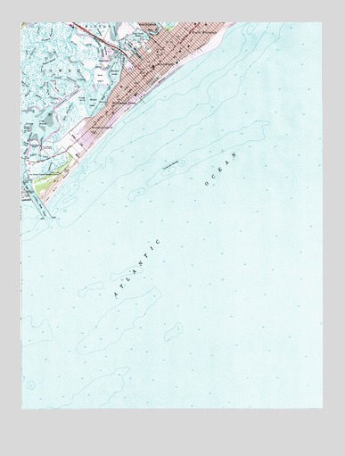
Wildwood, NJ USGS Topographic Map
Click on map above to begin viewing in our Map Viewer.

This topographic map contains these locations and features:
Feature Name Type Latitude Longitude GNIS ID View Map
Borough of Wildwood CrestCivilN38.9717°W74.8376°885445View Map
Bureau of Fire InspectionBuildingN38.9766°W74.8311°2401575View Map
Cape May InletBayN38.9390°W74.8691°875193View Map
City of WildwoodCivilN38.9877°W74.8189°885444View Map
Coast Guard Station Cape MayMilitaryN38.9502°W74.8616°2512100View Map
Cold Spring Harbor DockLocaleN38.9590°W74.8657°875546View Map
Cresse IslandIslandN38.9754°W74.8477°875721View Map
Crest Memorial Elementary SchoolSchoolN38.9634°W74.8500°2333334View Map
Diamond BeachPopulated PlaceN38.9596°W74.8524°1852606View Map
Diamond Beach Census Designated PlaceCensusN38.9585°W74.8517°2389406View Map
Downs GutGutN38.9621°W74.8657°882646View Map
Duck GutGutN38.9609°W74.8738°875989View Map
Ephraim IslandIslandN38.9837°W74.8366°876204View Map
Five Mile BeachBeachN38.9890°W74.8046°882649View Map
Flower MoundIslandN38.9654°W74.8713°876396View Map
Folly PointCapeN38.9815°W74.8635°882651View Map
Fort PointCapeN38.9815°W74.8616°876422View Map
Glenwood Avenue Elementary SchoolSchoolN38.9940°W74.8136°2333291View Map
Hildreth MeadowSwampN38.9951°W74.8413°877112View Map
Jarvis SoundBayN38.9673°W74.8677°877414View Map
Jarvis Sound ThorofareChannelN38.9773°W74.8627°877415View Map
Jones CreekStreamN38.9879°W74.8724°877484View Map
Long PointCapeN38.9709°W74.8727°877920View Map
Lower ThorofareChannelN38.9584°W74.8674°877974View Map
Margaret Mace Elementary SchoolSchoolN38.9993°W74.7978°2333337View Map
Meadow CreekStreamN38.9728°W74.8653°878235View Map
Middle ThorofareChannelN38.9590°W74.8718°878303View Map
Mile BeachBeachN38.9787°W74.8204°878326View Map
Mud IslandIslandN38.9884°W74.8321°882675View Map
North Wildwood Police Department WildwoodBuildingN38.9918°W74.8009°2730820View Map
North Wildwood Volunteer Fire CompanyBuildingN38.9991°W74.8009°2401568View Map
Old Lower ThorofareChannelN38.9551°W74.8629°878960View Map
Old Turtle CreekGutN38.9773°W74.8599°878971View Map
Ottens HarborBayN38.9912°W74.8282°879031View Map
Post CreekChannelN38.9954°W74.8310°879453View Map
Post Creek BasinBasinN38.9959°W74.8249°879454View Map
Reubens ThorofareChannelN38.9801°W74.8693°879668View Map
Richardson ChannelChannelN38.9921°W74.8416°879674View Map
Saint Ann Regional Elementary SchoolSchoolN38.9929°W74.8117°2333201View Map
Sedge CreekStreamN38.9879°W74.8413°880465View Map
Shaw CutoffChannelN38.9851°W74.8410°880519View Map
Shaw IslandIslandN38.9823°W74.8421°880520View Map
ShawcrestPopulated PlaceN38.9876°W74.8379°880522View Map
Shell PileIslandN38.9693°W74.8629°880533View Map
Shell ThorofareChannelN38.9704°W74.8549°880536View Map
Southwest Cove PointCapeN38.9645°W74.8743°882694View Map
Stingaree CreekStreamN38.9807°W74.8480°880905View Map
Stingaree PointCapeN38.9807°W74.8491°880906View Map
Stites CreekGutN38.9904°W74.8518°880909View Map
Sunset LakeLakeN38.9740°W74.8435°881012View Map
Swain ChannelChannelN38.9821°W74.8563°881034View Map
Taylor CreekStreamN38.9884°W74.8691°881102View Map
Taylor SoundBayN38.9862°W74.8635°881105View Map
Terrapin ThorofareChannelN38.9940°W74.8627°881140View Map
Thorofare IslandIslandN38.9596°W74.8691°881167View Map
Turtle Gut ShoalsBarN38.9526°W74.8121°881306View Map
Two Mile BeachBeachN38.9484°W74.8574°881318View Map
WDOX-FM (Wildwood Crest)TowerN38.9926°W74.8129°884633View Map
West Wildwood Fire DepartmentBuildingN38.9991°W74.8267°2401839View Map
WildwoodPopulated PlaceN38.9918°W74.8149°881829View Map
Wildwood Catholic High SchoolSchoolN38.9991°W74.8019°2333385View Map
Wildwood CrestPopulated PlaceN38.9748°W74.8335°881831View Map
Wildwood Crest Emergency Medical Services / RescueBuildingN38.9627°W74.8509°2660102View Map
Wildwood Crest Emergency Medical Services / RescueBuildingN38.9627°W74.8508°2401838View Map
Wildwood Crest Police DepartmentBuildingN38.9766°W74.8309°2730773View Map
Wildwood Crest Volunteer Fire Company 1BuildingN38.9721°W74.8379°2401661View Map
Wildwood Fire Department Station 3 - 1 Holly Beach Volunteer Fire Company 1BuildingN38.9872°W74.8217°2401805View Map
Wildwood Fire Department Station 3 - 2 Wildwood Volunteer Fire Company 1BuildingN38.9919°W74.8131°2401701View Map
Wildwood Fire Department Station 3 HeadquartersBuildingN38.9866°W74.8221°2401711View Map
Wildwood GablesPopulated PlaceN38.9657°W74.8460°881832View Map
Wildwood HighSchoolN38.9856°W74.8195°2333369View Map
Wildwood Middle SchoolSchoolN38.9856°W74.8196°2333229View Map
Wildwood Police DepartmentBuildingN38.9865°W74.8219°2730772View Map
York CreekStreamN38.9805°W74.8717°881985View Map

Note: Coordinates in the location and feature list above are referenced to NAD83 datum.


Copyright (C) 2008-2024 Ryan Niemi / Sunset Dynamics ... All Rights Reserved