TopoQuest Logo
Do you find TopoQuest useful?
Help keep TopoQuest running and adding new maps/features by donating!
Bitcoin:  19c7KJd3qBynnjoSw5npx9KScwjBe4ifkT
Litecoin:  LXs6TkuXGGXo1vDsWCkWVdjQX94eUKd6ui
Home View Maps Find Maps Find Places Resources & Links


Bordley, Kentucky Topographic Map

USGS Map Title: Bordley, KY
USGS Map MRC: 37087E7
DRG (GeoTIFF) Download: o37087e7.tif


Neighboring USGS Topographic Map Quads:


  Morganfield, KY  
37087F8
 

  Waverly, KY  
37087F7
 

  Poole, KY  
37087F6
 

  Sturgis, KY  
37087E8
 

  Bordley, KY  
37087E7
 

  Dixon, KY  
37087E6
 

  Blackford, KY  
37087D8
 

  Providence, KY  
37087D7
 

  Nebo, KY  
37087D6


Map MRC Location:

N38°
W88°
N38°
W87°
H8 H7 H6 H5 H4 H3 H2 H1
G8 G7 G6 G5 G4 G3 G2 G1
F8 F7 F6 F5 F4 F3 F2 F1
E8 E7 E6 E5 E4 E3 E2 E1
D8 D7 D6 D5 D4 D3 D2 D1
C8 C7 C6 C5 C4 C3 C2 C1
B8 B7 B6 B5 B4 B3 B2 B1
A8 A7 A6 A5 A4 A3 A2 A1
N37°
W88°
N37°
W87°

Bordley, KY USGS 1:24K Topographic Map Preview:
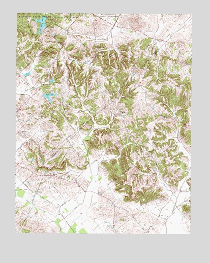
Bordley, KY USGS Topographic Map
Click on map above to begin viewing in our Map Viewer.

This topographic map contains these locations and features:
Feature Name Type Latitude Longitude GNIS ID View Map
Ashland ChurchChurchN37.5073°W87.7950°486093View Map
BordleyPopulated PlaceN37.5592°W87.8697°507556View Map
Cap Mauzy LakeReservoirN37.6189°W87.8570°488910View Map
Caton CemeteryCemeteryN37.6045°W87.7689°489096View Map
Cedar Grove ChurchChurchN37.6033°W87.7576°489208View Map
Free UnionPopulated PlaceN37.5253°W87.7542°508036View Map
GivensPopulated PlaceN37.6112°W87.7722°508094View Map
Harnion CemeteryCemeteryN37.6070°W87.7653°493774View Map
HearinPopulated PlaceN37.5331°W87.8486°508212View Map
Holeman CemeteryCemeteryN37.6089°W87.8414°494385View Map
Lynn ForkStreamN37.5137°W87.7617°497379View Map
Moffit LakeReservoirN37.5778°W87.8515°498470View Map
Nall DitchCanalN37.5253°W87.7656°499157View Map
Oak Grove CemeteryCemeteryN37.5961°W87.8372°499664View Map
Old Cedar Grove ChurchChurchN37.5963°W87.7539°499811View Map
Persimmon RidgeRidgeN37.5989°W87.8286°500444View Map
Richards CemeteryCemeteryN37.5689°W87.8367°501797View Map
SheltonPopulated PlaceN37.5687°W87.7961°509046View Map
Springer HillSummitN37.6075°W87.8100°504156View Map
Sugarcamp CreekStreamN37.5306°W87.8197°504694View Map
Waggener ChurchChurchN37.5470°W87.7770°506097View Map
Walnut Grove ChurchChurchN37.5925°W87.8142°506176View Map
WilliamsPopulated PlaceN37.5237°W87.8597°509373View Map
YubaPopulated PlaceN37.5762°W87.8386°509424View Map
Yuba RidgeRidgeN37.5750°W87.8406°507262View Map

Note: Coordinates in the location and feature list above are referenced to NAD83 datum.


Copyright (C) 2008-2024 Ryan Niemi / Sunset Dynamics ... All Rights Reserved