TopoQuest Logo
Do you find TopoQuest useful?
Help keep TopoQuest running and adding new maps/features by donating!
Bitcoin:  19c7KJd3qBynnjoSw5npx9KScwjBe4ifkT
Litecoin:  LXs6TkuXGGXo1vDsWCkWVdjQX94eUKd6ui
Home View Maps Find Maps Find Places Resources & Links


Whitley City, Kentucky Topographic Map

USGS Map Title: Whitley City, KY
USGS Map MRC: 36084F4
DRG (GeoTIFF) Download: o36084f4.tif


Neighboring USGS Topographic Map Quads:


  Nevelsville, KY  
36084G5
 

  Wiborg, KY  
36084G4
 

  Cumberland Falls, KY  
36084G3
 

  Barthell, KY  
36084F5
 

  Whitley City, KY  
36084F4
 

  Hollyhill, KY  
36084F3
 

  Oneida North, TN  
36084E5
 

  Winfield, TN  
36084E4
 

  Ketchen, TN  
36084E3


Map MRC Location:

N37°
W85°
N37°
W84°
H8 H7 H6 H5 H4 H3 H2 H1
G8 G7 G6 G5 G4 G3 G2 G1
F8 F7 F6 F5 F4 F3 F2 F1
E8 E7 E6 E5 E4 E3 E2 E1
D8 D7 D6 D5 D4 D3 D2 D1
C8 C7 C6 C5 C4 C3 C2 C1
B8 B7 B6 B5 B4 B3 B2 B1
A8 A7 A6 A5 A4 A3 A2 A1
N36°
W85°
N36°
W84°

Whitley City, KY USGS 1:24K Topographic Map Preview:
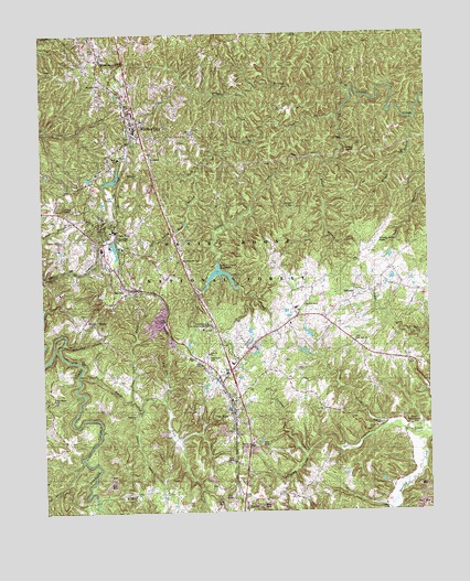
Whitley City, KY USGS Topographic Map
Click on map above to begin viewing in our Map Viewer.

This topographic map contains these locations and features:
Feature Name Type Latitude Longitude GNIS ID View Map
American Legion KnollSummitN36.7017°W84.4877°516538View Map
Battery CreekStreamN36.6879°W84.4430°510431View Map
Bowman BranchStreamN36.6526°W84.4685°517053View Map
Bridge ForkStreamN36.7284°W84.4033°510913View Map
Buncomb BranchStreamN36.6692°W84.4938°511065View Map
Cal CreekStreamN36.6473°W84.3883°511244View Map
Cal Hill CemeteryCemeteryN36.6473°W84.3913°511247View Map
Cal Hill ChurchChurchN36.6517°W84.4088°511248View Map
Carter CemeteryCemeteryN36.7406°W84.4985°511236View Map
Chewford CreekStreamN36.6404°W84.4158°511341View Map
East Apple Tree BranchStreamN36.7131°W84.4502°511984View Map
East Apple Tree ChurchChurchN36.6909°W84.4558°511985View Map
East Pine Knot ChurchChurchN36.6695°W84.3991°511995View Map
Elisha BranchStreamN36.7167°W84.4080°512026View Map
Freewill ChurchChurchN36.6662°W84.4466°512253View Map
GilreathPopulated PlaceN36.6806°W84.3997°512317View Map
Gilreath CemeteryCemeteryN36.7051°W84.4180°512318View Map
Hickory GrovePopulated PlaceN36.6751°W84.4863°512682View Map
Hill CemeteryCemeteryN36.6270°W84.4544°512706View Map
Hollaway CemeteryCemeteryN36.7373°W84.4794°512747View Map
Indian KnobSummitN36.7190°W84.3974°512915View Map
Jenneys BranchStreamN36.7348°W84.3994°512993View Map
Laurel Creek ReservoirReservoirN36.6887°W84.4426°509430View Map
Laurel Creek TrailTrailN36.7159°W84.4074°516761View Map
Lower Marsh Creek ChurchChurchN36.6476°W84.3805°513705View Map
Marshes SidingPopulated PlaceN36.7437°W84.4808°513799View Map
Mc Creary County AirportAirportN36.6927°W84.3938°517475View Map
McCreary CountyCivilN36.7371°W84.4842°516926View Map
McCreary County Ambulance ServiceBuildingN36.7243°W84.4701°2719135View Map
McCreary County Search and RescueBuildingN36.7272°W84.4718°2637397View Map
McCreary County Sheriff's OffficeBuildingN36.7258°W84.4704°2767649View Map
Meadow Grove ChurchChurchN36.6790°W84.4152°513894View Map
Mount Pleasant ChurchChurchN36.6292°W84.4713°514109View Map
Otter CreekStreamN36.6267°W84.4827°514374View Map
Pine KnotPopulated PlaceN36.6509°W84.4385°514591View Map
Pine Knot CemeteryCemeteryN36.6651°W84.4474°514592View Map
Pine Knot Census Designated PlaceCensusN36.6648°W84.4394°2403414View Map
Pine Knot DivisionCivilN36.6458°W84.4016°1937203View Map
Pine Knot Fire StationBuildingN36.6674°W84.4420°2637030View Map
Pine Knot Job Corps CenterLocaleN36.6731°W84.4469°509454View Map
ReveloPopulated PlaceN36.6834°W84.4705°514894View Map
Ross Grove ChurchChurchN36.6545°W84.4972°515118View Map
Roundtop ChurchChurchN36.6498°W84.4708°516542View Map
SilervillePopulated PlaceN36.6267°W84.4352°515409View Map
Silerville ChurchChurchN36.6251°W84.4349°515410View Map
Smith ForkStreamN36.6612°W84.4891°515513View Map
South McCreary Fire and Rescue Main StationBuildingN36.6648°W84.4483°2637430View Map
StearnsPopulated PlaceN36.6990°W84.4774°515673View Map
Stearns Census Designated PlaceCensusN36.6957°W84.4769°2402896View Map
Stearns Post OfficePost OfficeN36.6963°W84.4790°2558387View Map
Stearns Ranger StationLocaleN36.7165°W84.4819°515674View Map
Stearns State Lookout TowerTowerN36.7048°W84.4927°516763View Map
Stearns-Whitley City DivisionCivilN36.7369°W84.4500°1937277View Map
Strunk Post OfficePost OfficeN36.6267°W84.4352°1721343View Map
Sweet Gum BranchStreamN36.6542°W84.4727°515830View Map
United Sates Penitentiary McCrearyBuildingN36.6881°W84.3888°2767796View Map
WEQO-AM (Whitley City)TowerN36.7459°W84.4824°517671View Map
WHAY-FM (Whitley City)TowerN36.7442°W84.4769°517745View Map
Whitley CityPopulated PlaceN36.7234°W84.4705°516340View Map
Whitley City Census Designated PlaceCensusN36.7238°W84.4731°2403026View Map
Whitley City Fire StationBuildingN36.7243°W84.4700°2636808View Map
Wolf Pen CreekStreamN36.6545°W84.4616°516449View Map
Wright BranchStreamN36.7276°W84.3785°516488View Map

Note: Coordinates in the location and feature list above are referenced to NAD83 datum.


Copyright (C) 2008-2024 Ryan Niemi / Sunset Dynamics ... All Rights Reserved