TopoQuest Logo
Do you find TopoQuest useful?
Help keep TopoQuest running and adding new maps/features by donating!
Bitcoin:  19c7KJd3qBynnjoSw5npx9KScwjBe4ifkT
Litecoin:  LXs6TkuXGGXo1vDsWCkWVdjQX94eUKd6ui
Home View Maps Find Maps Find Places Resources & Links


Whiteville, Tennessee Topographic Map

USGS Map Title: Whiteville, TN
USGS Map MRC: 35089C2
DRG (GeoTIFF) Download: o35089c2.tif


Neighboring USGS Topographic Map Quads:


  Dancyville, TN  
35089D3
 

  Hillville, TN  
35089D2
 

  Mercer, TN  
35089D1
 

  Laconia, TN  
35089C3
 

  Whiteville, TN  
35089C2
 

  Bolivar West, TN  
35089C1
 

  Somerville, TN  
35089B3
 

  Hickory Valley, TN  
35089B2
 

  Middleburg, TN  
35089B1


Map MRC Location:

N36°
W90°
N36°
W89°
H8 H7 H6 H5 H4 H3 H2 H1
G8 G7 G6 G5 G4 G3 G2 G1
F8 F7 F6 F5 F4 F3 F2 F1
E8 E7 E6 E5 E4 E3 E2 E1
D8 D7 D6 D5 D4 D3 D2 D1
C8 C7 C6 C5 C4 C3 C2 C1
B8 B7 B6 B5 B4 B3 B2 B1
A8 A7 A6 A5 A4 A3 A2 A1
N35°
W90°
N35°
W89°

Whiteville, TN USGS 1:24K Topographic Map Preview:
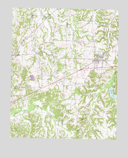
Whiteville, TN USGS Topographic Map
Click on map above to begin viewing in our Map Viewer.

This topographic map contains these locations and features:
Feature Name Type Latitude Longitude GNIS ID View Map
Antioch Missionary Baptist ChurchChurchN35.2576°W89.1690°1304844View Map
Bear Creek Lake Dam Number TwoDamN35.3501°W89.2217°1301766View Map
Bear Creek Lake Number TwoReservoirN35.3505°W89.2214°1301767View Map
Bear Creek Watershed Dam Number OneDamN35.3667°W89.2251°1301773View Map
Bear Creek Watershed Lake Number OneReservoirN35.3657°W89.2262°1301772View Map
Bethany CemeteryCemeteryN35.2562°W89.1695°1277076View Map
Carnes CemeteryCemeteryN35.3720°W89.1723°1279688View Map
Clover Garden ChurchChurchN35.3684°W89.2067°1319801View Map
Clover Garden SchoolSchoolN35.3684°W89.2067°1280774View Map
Commissioner District 3CivilN35.3174°W89.1529°2464152View Map
Crowder Cemetery BarrensCemeteryN35.3084°W89.1642°1281744View Map
Elcanaan Baptist ChurchChurchN35.3309°W89.1476°1319751View Map
Farley CemeteryCemeteryN35.3484°W89.1428°1284131View Map
Fayette CornersPopulated PlaceN35.3662°W89.2095°1284174View Map
First Baptist ChurchChurchN35.3256°W89.1492°1319753View Map
First United Methodist ChurchChurchN35.3256°W89.1478°1319754View Map
Gallaway Volunteer Fire DepartmentBuildingN35.3260°W89.1508°2654176View Map
Hardeman County Correctional FacilityBuildingN35.2872°W89.1597°2766074View Map
Ina (historical)Populated PlaceN35.2959°W89.2181°1311580View Map
Ina School (historical)SchoolN35.2948°W89.2140°1319841View Map
Lewis SchoolSchoolN35.2993°W89.2292°1291091View Map
Mount MoriahPopulated PlaceN35.3323°W89.2178°1647507View Map
Mount Moriah CemeteryCemeteryN35.3326°W89.2148°1319866View Map
Mount Moriah ChurchChurchN35.3329°W89.2156°1294676View Map
Mount Moriah SchoolSchoolN35.3323°W89.2184°1294683View Map
Northeast Fayette County Fire DepartmentBuildingN35.3308°W89.2292°2653688View Map
Perry CemeteryCemeteryN35.2587°W89.2459°1297202View Map
Pleasant Hill CemeteryCemeteryN35.2973°W89.2465°1297851View Map
Pleasant Hill Church (historical)ChurchN35.2970°W89.2465°1319895View Map
Rhodes Store (historical)LocaleN35.3301°W89.2209°1319903View Map
Smith ChapelChurchN35.3293°W89.2451°1270658View Map
Smith Number Three SchoolSchoolN35.3293°W89.2442°1303686View Map
Smyrna ChurchChurchN35.3687°W89.2270°1270741View Map
Town of WhitevilleCivilN35.3181°W89.1495°2406881View Map
Trainer CemeteryCemeteryN35.3251°W89.2490°1272831View Map
Union Hill ChurchChurchN35.3445°W89.1542°1273238View Map
Union SchoolSchoolN35.2679°W89.1648°1273248View Map
WhitevillePopulated PlaceN35.3265°W89.1495°1274472View Map
Whiteville City HallBuildingN35.3262°W89.1495°1319784View Map
Whiteville Correctional FacilityBuildingN35.2990°W89.1531°2766073View Map
Whiteville Division (historical)CensusN35.3359°W89.1365°1648750View Map
Whiteville Elementary SchoolSchoolN35.3242°W89.1476°1319785View Map
Whiteville LakeReservoirN35.2949°W89.1306°1274473View Map
Whiteville Lake DamDamN35.3004°W89.1334°1307094View Map
Whiteville Police DepartmentBuildingN35.3263°W89.1494°2765731View Map
Whiteville Post OfficePost OfficeN35.3260°W89.1517°1651330View Map
Whiteville Volunteer Fire DepartmentBuildingN35.3185°W89.1499°2653641View Map

Note: Coordinates in the location and feature list above are referenced to NAD83 datum.


Copyright (C) 2008-2024 Ryan Niemi / Sunset Dynamics ... All Rights Reserved