TopoQuest Logo
Do you find TopoQuest useful?
Help keep TopoQuest running and adding new maps/features by donating!
Bitcoin:  19c7KJd3qBynnjoSw5npx9KScwjBe4ifkT
Litecoin:  LXs6TkuXGGXo1vDsWCkWVdjQX94eUKd6ui
Home View Maps Find Maps Find Places Resources & Links


Whitesville, Georgia Topographic Map

USGS Map Title: Whitesville, GA
USGS Map MRC: 32085G1
DRG (GeoTIFF) Download: o32085g1.tif


Neighboring USGS Topographic Map Quads:


  Lanett North, AL  
32085H2
 

  Cannonville, GA  
32085H1
 

  Hilyer, GA  
32084H8
 

  Lanett South, AL  
32085G2
 

  Whitesville, GA  
32085G1
 

  Pine Mountain SW, GA  
32084G8
 

  Beulah, AL  
32085F2
 

  Bartletts Ferry Dam, GA  
32085F1
 

  Mulberry Grove, GA  
32084F8


Map MRC Location:

N33°
W86°
N33°
W85°
H8 H7 H6 H5 H4 H3 H2 H1
G8 G7 G6 G5 G4 G3 G2 G1
F8 F7 F6 F5 F4 F3 F2 F1
E8 E7 E6 E5 E4 E3 E2 E1
D8 D7 D6 D5 D4 D3 D2 D1
C8 C7 C6 C5 C4 C3 C2 C1
B8 B7 B6 B5 B4 B3 B2 B1
A8 A7 A6 A5 A4 A3 A2 A1
N32°
W86°
N32°
W85°

Whitesville, GA USGS 1:24K Topographic Map Preview:
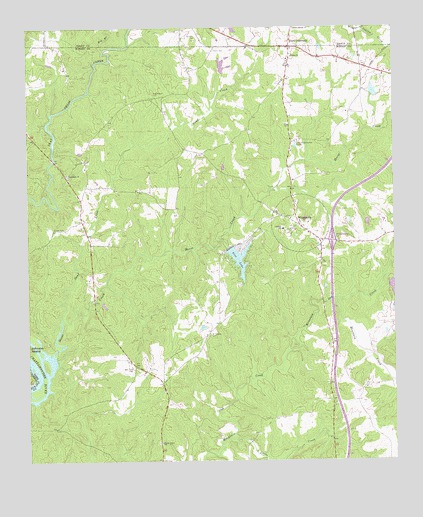
Whitesville, GA USGS Topographic Map
Click on map above to begin viewing in our Map Viewer.

This topographic map contains these locations and features:
Feature Name Type Latitude Longitude GNIS ID View Map
Avery LakeReservoirN32.8565°W85.0067°338461View Map
Avery Lake DamDamN32.8551°W85.0066°338460View Map
Big BranchStreamN32.8687°W85.0983°311344View Map
Billingslea CemeteryCemeteryN32.7862°W85.0624°311430View Map
Callaway Enterprises LakeReservoirN32.8001°W85.0049°340649View Map
Callaway Enterprises Lake DamDamN32.8001°W85.0049°340648View Map
Cooks CemeteryCemeteryN32.8173°W85.1163°312923View Map
Flat Shoal ChurchChurchN32.8326°W85.1110°355831View Map
Flat Shoals BridgeBridgeN32.8368°W85.1158°350964View Map
House CreekStreamN32.7801°W85.1169°356324View Map
Hutchinson CemeteryCemeteryN32.8560°W85.0810°315864View Map
Ingram CreekStreamN32.8740°W85.0113°315922View Map
Interchange 12CrossingN32.8135°W85.0210°350980View Map
Jackson Recreation CenterBuildingN32.8421°W85.0335°316021View Map
Johnson SchoolSchoolN32.8168°W85.0377°316183View Map
Jones CrossroadsPopulated PlaceN32.8696°W85.0347°326349View Map
Little CreekStreamN32.7576°W85.0552°317036View Map
Mountain CreekStreamN32.7968°W85.0205°319063View Map
New HopePopulated PlaceN32.7774°W85.0888°350989View Map
New Hope CemeteryCemeteryN32.7765°W85.0891°319357View Map
New Hope Methodist Church (historical)ChurchN32.7768°W85.0891°350990View Map
Northwest Harris Volunteer Fire DepartmentBuildingN32.8170°W85.0378°2603800View Map
Pearson Mill (historical)LocaleN32.8365°W85.1155°350995View Map
Pine LakePopulated PlaceN32.8076°W85.0505°350998View Map
Pine LakeReservoirN32.8083°W85.0530°320619View Map
Pine Mountain DivisionCivilN32.8229°W85.0074°1936470View Map
Rivers CemeteryCemeteryN32.8685°W85.0602°321639View Map
Sand CreekStreamN32.7915°W85.1135°322409View Map
Shady GrovePopulated PlaceN32.7562°W85.0805°351002View Map
Shady Grove CemeteryCemeteryN32.7551°W85.0808°351003View Map
Shady Grove ChurchChurchN32.7551°W85.0797°322757View Map
Union ChurchChurchN32.8668°W85.0338°324525View Map
WhitesvillePopulated PlaceN32.8176°W85.0313°325224View Map
Williams CemeteryCemeteryN32.8723°W85.0660°325334View Map

Note: Coordinates in the location and feature list above are referenced to NAD83 datum.


Copyright (C) 2008-2024 Ryan Niemi / Sunset Dynamics ... All Rights Reserved