TopoQuest Logo
Do you find TopoQuest useful?
Help keep TopoQuest running and adding new maps/features by donating!
Bitcoin:  19c7KJd3qBynnjoSw5npx9KScwjBe4ifkT
Litecoin:  LXs6TkuXGGXo1vDsWCkWVdjQX94eUKd6ui
Home View Maps Find Maps Find Places Resources & Links


White Hall, Arkansas Topographic Map

USGS Map Title: White Hall, AR
USGS Map MRC: 34092C1
DRG (GeoTIFF) Download: o34092c1.tif


Neighboring USGS Topographic Map Quads:


  Redfield, AR  
34092D2
 

  Wright, AR  
34092D1
 

  Sherrill, AR  
34091D8
 

  Hardin, AR  
34092C2
 

  White Hall, AR  
34092C1
 

  Rob Roy, AR  
34091C8
 

  Pine Bluff NW, AR  
34092B2
 

  Pine Bluff, AR  
34092B1
 

  Ladd, AR  
34091B8


Map MRC Location:

N35°
W93°
N35°
W92°
H8 H7 H6 H5 H4 H3 H2 H1
G8 G7 G6 G5 G4 G3 G2 G1
F8 F7 F6 F5 F4 F3 F2 F1
E8 E7 E6 E5 E4 E3 E2 E1
D8 D7 D6 D5 D4 D3 D2 D1
C8 C7 C6 C5 C4 C3 C2 C1
B8 B7 B6 B5 B4 B3 B2 B1
A8 A7 A6 A5 A4 A3 A2 A1
N34°
W93°
N34°
W92°

White Hall, AR USGS 1:24K Topographic Map Preview:
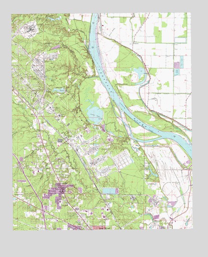
White Hall, AR USGS Topographic Map
Click on map above to begin viewing in our Map Viewer.

This topographic map contains these locations and features:
Feature Name Type Latitude Longitude GNIS ID View Map
Arnold CreekStreamN34.3101°W92.1118°45935View Map
Arsenal LakeReservoirN34.3720°W92.0928°80481View Map
Arsenal Lake DamDamN34.3718°W92.0951°80480View Map
BaldwinPopulated PlaceN34.2876°W92.0760°60880View Map
Barnett ChapelChurchN34.2879°W92.0332°46113View Map
Barrett Chapel Church (historical)ChurchN34.2704°W92.0279°60883View Map
Barrett Chapel School (historical)SchoolN34.2704°W92.0276°60882View Map
Bayou NarrowBasinN34.3690°W92.0638°46180View Map
Bethany ChurchChurchN34.2554°W92.0901°46422View Map
Big Grassy Lake (historical)LakeN34.3468°W92.0196°60893View Map
Caney Bayou ForkStreamN34.2948°W92.0932°47393View Map
Cedar HillLocaleN34.3745°W92.0988°47614View Map
Central Baptist ChurchChurchN34.2504°W92.0704°60874View Map
Chapel Hill Church (historical)ChurchN34.2701°W92.0607°60878View Map
Cheek CemeteryCemeteryN34.3573°W92.0412°60891View Map
Cheek Church (historical)ChurchN34.3573°W92.0407°60892View Map
Christian Church (historical)ChurchN34.3487°W92.0007°60894View Map
City of White HallCivilN34.2736°W92.1003°2405731View Map
Clear PondLakeN34.3307°W92.1004°76633View Map
College Park (historical)Populated PlaceN34.2640°W92.0596°60877View Map
DexterPopulated PlaceN34.3168°W92.1085°56989View Map
Dexter GateLocaleN34.3179°W92.1065°48501View Map
Dilly PondLakeN34.3092°W92.0675°76798View Map
Eastwood BayouStreamN34.3543°W92.0715°48791View Map
First Baptist Church of White HallChurchN34.2737°W92.0901°60870View Map
Gamble CreekStreamN34.2990°W92.0988°76995View Map
Gandy Elementary SchoolSchoolN34.2558°W92.0944°2039307View Map
Grace Baptist ChurchChurchN34.2520°W92.0635°60875View Map
Gravel Hill School (historical)SchoolN34.2668°W92.0868°60863View Map
Haywood College (historical)SchoolN34.2629°W92.0599°60876View Map
Henslee HeightsPopulated PlaceN34.2623°W92.0829°57905View Map
Hensley Bar CutoffBendN34.3084°W92.0321°50021View Map
Hickory Ridge AirportAirportN34.2633°W92.1191°2717283View Map
Horseshoe PondLakeN34.3371°W92.0982°77235View Map
Jack Bradley BendBendN34.3004°W92.0082°60884View Map
Jackman School (historical)SchoolN34.3268°W92.0015°60887View Map
Jones LakeReservoirN34.2829°W92.0282°80485View Map
Jones Lake DamDamN34.2801°W92.0251°80484View Map
KPBQ-FM (Pine Bluff)TowerN34.2537°W92.0663°85238View Map
Lake LeeReservoirN34.2971°W92.0394°80489View Map
Lake Lee DamDamN34.2951°W92.0385°80488View Map
Lamb (historical)Populated PlaceN34.2676°W92.0696°83931View Map
LeitnerPopulated PlaceN34.2501°W92.0668°58053View Map
Lemonwood Missionary Baptist ChurchChurchN34.2707°W92.1032°60865View Map
Long Pond CreekStreamN34.3718°W92.0415°51440View Map
Main CanalCanalN34.3457°W92.0124°51615View Map
McFadden CemeteryCemeteryN34.2998°W92.0446°51830View Map
McFadden Reach (historical)ChannelN34.3126°W92.0321°60861View Map
McGregor Reach (historical)ChannelN34.3132°W92.0593°60862View Map
Memorial Park CemeteryCemeteryN34.2579°W92.0762°51908View Map
Moody Elementary SchoolSchoolN34.2843°W92.1072°2039306View Map
Morris ChapelChurchN34.3254°W92.0346°60888View Map
Morris Chapel School (historical)SchoolN34.3257°W92.0349°60889View Map
Mount Ida Church (historical)ChurchN34.3120°W92.1076°60873View Map
Musgrove CemeteryCemeteryN34.3112°W92.1043°52562View Map
National Center for Toxicological ResearchLocaleN34.3668°W92.1118°82518View Map
Paradise ChurchChurchN34.3251°W92.1176°53176View Map
PastoriaPopulated PlaceN34.3582°W92.0401°57153View Map
Pastoria BendBendN34.3404°W92.0338°60890View Map
Phillips CreekStreamN34.3387°W92.0643°53338View Map
Pine Bluff ArsenalBuildingN34.3227°W92.1002°2118665View Map
Pine Bluff ArsenalBuildingN34.3181°W92.0963°2625416View Map
Pine Bluff ArsenalMilitaryN34.3326°W92.0868°2511976View Map
Plain ViewPopulated PlaceN34.3015°W92.1043°60879View Map
Plainview GateLocaleN34.3023°W92.0857°53516View Map
Saint Lukes Baptist ChurchChurchN34.3287°W92.0001°78251View Map
Saint Stephen CemeteryCemeteryN34.3170°W92.0024°60885View Map
Saint Stephen Church (historical)ChurchN34.3170°W92.0026°60886View Map
Smiths BayouStreamN34.3595°W92.0557°54961View Map
Taylor Elementary SchoolSchoolN34.2667°W92.0924°60864View Map
Toney Lake (historical)ReservoirN34.2718°W92.0885°60871View Map
Township of PastoriaCivilN34.3562°W92.0195°66740View Map
Tripletts BluffCliffN34.3493°W92.0690°55658View Map
Tulley CreekStreamN34.3379°W92.0710°55694View Map
Tulley LakeReservoirN34.3308°W92.0919°80483View Map
Tulley Lake DamDamN34.3318°W92.0885°80482View Map
WarbrittonPopulated PlaceN34.2765°W92.0310°58826View Map
Warbritton GateLocaleN34.2793°W92.0340°56035View Map
Waterloo Drainage DitchCanalN34.3284°W92.0129°56094View Map
White HallPopulated PlaceN34.2740°W92.0910°58868View Map
White Hall City ParkParkN34.2757°W92.0976°60866View Map
White Hall High SchoolSchoolN34.2835°W92.1106°60872View Map
White Hall Junior High SchoolSchoolN34.2725°W92.0912°60869View Map
White Hall Police DepartmentBuildingN34.2738°W92.0914°2118663View Map
White Hall SchoolSchoolN34.3029°W92.0868°56256View Map
White Hall Shopping CenterLocaleN34.2768°W92.0918°60868View Map
White Hall United Methodist ChurchChurchN34.2754°W92.0940°60867View Map
White Hall Volunteer Fire Department Station 1BuildingN34.2762°W92.0940°2117314View Map
Yell Lake (historical)ReservoirN34.2584°W92.0351°60881View Map
Yellow BluffCliffN34.3165°W92.0757°56592View Map
Yellow LakeReservoirN34.3170°W92.0676°77325View Map

Note: Coordinates in the location and feature list above are referenced to NAD83 datum.


Copyright (C) 2008-2024 Ryan Niemi / Sunset Dynamics ... All Rights Reserved