TopoQuest Logo
Do you find TopoQuest useful?
Help keep TopoQuest running and adding new maps/features by donating!
Bitcoin:  19c7KJd3qBynnjoSw5npx9KScwjBe4ifkT
Litecoin:  LXs6TkuXGGXo1vDsWCkWVdjQX94eUKd6ui
Home View Maps Find Maps Find Places Resources & Links


Boonville, New York Topographic Map

USGS Map Title: Boonville, NY
USGS Map MRC: 43075D3
DRG (GeoTIFF) Download: o43075d3.tif


Neighboring USGS Topographic Map Quads:


  Constableville, NY  
43075E4
 

  Port Leyden, NY  
43075E3


  West Leyden, NY  
43075D4
 

  Boonville, NY  
43075D3
 

  Forestport, NY  
43075D2
 

  Westernville, NY  
43075C4
 

  North Western, NY  
43075C3
 

  Remsen, NY  
43075C2


Map MRC Location:

N44°
W76°
N44°
W75°
H8 H7 H6 H5 H4 H3 H2 H1
G8 G7 G6 G5 G4 G3 G2 G1
F8 F7 F6 F5 F4 F3 F2 F1
E8 E7 E6 E5 E4 E3 E2 E1
D8 D7 D6 D5 D4 D3 D2 D1
C8 C7 C6 C5 C4 C3 C2 C1
B8 B7 B6 B5 B4 B3 B2 B1
A8 A7 A6 A5 A4 A3 A2 A1
N43°
W76°
N43°
W75°

Boonville, NY USGS 1:24K Topographic Map Preview:
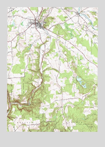
Boonville, NY USGS Topographic Map
Click on map above to begin viewing in our Map Viewer.

This topographic map contains these locations and features:
Feature Name Type Latitude Longitude GNIS ID View Map
Abundant Life Fellowship ChurchChurchN43.4620°W75.2815°2615492View Map
Adirondack High SchoolSchoolN43.4789°W75.3506°2437701View Map
Bamber School (historical)SchoolN43.4067°W75.2983°2100979View Map
Big BranchStreamN43.3751°W75.2927°969878View Map
Black River CanalCanalN43.4592°W75.3193°944183View Map
BoonvillePopulated PlaceN43.4837°W75.3366°944443View Map
Boonville CemeteryCemeteryN43.4844°W75.3235°2568191View Map
Boonville Fire CompanyBuildingN43.4822°W75.3329°2718303View Map
Boonville Fire DepartmentBuildingN43.4790°W75.3327°2718603View Map
Boonville Gorge State ParkParkN43.4045°W75.3352°944444View Map
Boonville Inc AirportAirportN43.4681°W75.2525°977919View Map
Boonville QuarryMineN43.4675°W75.3189°2567154View Map
Boonville ReservoirReservoirN43.4616°W75.3415°944445View Map
Boonville SchoolSchoolN43.4825°W75.3367°2437707View Map
Boonville United Methodist ChurchChurchN43.4828°W75.3314°2437730View Map
Boonville Wastewater Treatment PlantLocaleN43.4880°W75.3297°2617702View Map
Buck Hill School (historical)SchoolN43.3764°W75.3628°2100978View Map
Christian Missionary ChurchChurchN43.4697°W75.3056°2437731View Map
Clark BrookStreamN43.4023°W75.3696°946745View Map
Clark HillSummitN43.3820°W75.3349°946762View Map
Cold BrookStreamN43.4923°W75.2727°947038View Map
Crystal CreekStreamN43.4956°W75.2546°947891View Map
Cummings CreekStreamN43.4990°W75.2752°947934View Map
East Kent CreekStreamN43.4859°W75.2604°949145View Map
Echo LakeLakeN43.4247°W75.2725°949343View Map
Egypt CemeteryCemeteryN43.4116°W75.2663°949431View Map
Erwin Library and InstituteBuildingN43.4840°W75.3363°2617267View Map
Erwin ParkParkN43.4840°W75.3263°949700View Map
HawkinsvillePopulated PlaceN43.4937°W75.2771°952408View Map
Hayes CemeteryCemeteryN43.4862°W75.2936°952443View Map
HurlbutvillePopulated PlaceN43.4026°W75.3471°972642View Map
Jackson HillSummitN43.4331°W75.3524°953888View Map
Kingdom Hall of Jehovahs WitnessesChurchN43.4834°W75.3045°2616563View Map
North Steuben CemeteryCemeteryN43.3853°W75.3127°2568182View Map
North Steuben ChurchChurchN43.3853°W75.3135°958930View Map
Park HillSummitN43.4812°W75.3224°959879View Map
Penn MountainSummitN43.3795°W75.2599°960142View Map
Pixley FallsFallsN43.4023°W75.3441°960653View Map
Potato HillSummitN43.4440°W75.3035°961025View Map
Reservoir School (historical)SchoolN43.4528°W75.3442°2100983View Map
Saint Joseph's ChurchChurchN43.4814°W75.3317°2437732View Map
School Number 11 (historical)SchoolN43.4912°W75.2752°975007View Map
School Number 16 (historical)SchoolN43.4608°W75.2828°2100981View Map
School Number 2 (historical)SchoolN43.4467°W75.2628°2100980View Map
School Number 3 (historical)SchoolN43.4656°W75.3697°2100984View Map
School Number 5 (historical)SchoolN43.4503°W75.3019°2100982View Map
Sperry HillSummitN43.4884°W75.3146°965997View Map
Sunset Nursing HomeBuildingN43.4781°W75.3326°2614797View Map
Town of BoonvilleCivilN43.4661°W75.2928°978743View Map
Trinity Episcopal ChurchChurchN43.4833°W75.3375°2437733View Map
Village of BoonvilleCivilN43.4813°W75.3297°2391556View Map
WBRV-FM (Boonville)TowerN43.4481°W75.3463°977686View Map
West Kent CreekStreamN43.4803°W75.2668°970771View Map
Wingate SwampSwampN43.4767°W75.2885°971489View Map
Woodgate Pines Golf ClubLocaleN43.4883°W75.2922°974743View Map

Note: Coordinates in the location and feature list above are referenced to NAD83 datum.


Copyright (C) 2008-2024 Ryan Niemi / Sunset Dynamics ... All Rights Reserved