TopoQuest Logo
Do you find TopoQuest useful?
Help keep TopoQuest running and adding new maps/features by donating!
Bitcoin:  19c7KJd3qBynnjoSw5npx9KScwjBe4ifkT
Litecoin:  LXs6TkuXGGXo1vDsWCkWVdjQX94eUKd6ui
Home View Maps Find Maps Find Places Resources & Links


Westford, New York Topographic Map

USGS Map Title: Westford, NY
USGS Map MRC: 42074F7
DRG (GeoTIFF) Download: o42074f7.tif


Neighboring USGS Topographic Map Quads:


  Richfield Springs, NY  
42074G8
 

  East Springfield, NY  
42074G7
 

  Sprout Brook, NY  
42074G6
 

  Cooperstown, NY  
42074F8
 

  Westford, NY  
42074F7
 

  South Valley, NY  
42074F6
 

  Milford, NY  
42074E8
 

  Schenevus, NY  
42074E7
 

  Charlotteville, NY  
42074E6


Map MRC Location:

N43°
W75°
N43°
W74°
H8 H7 H6 H5 H4 H3 H2 H1
G8 G7 G6 G5 G4 G3 G2 G1
F8 F7 F6 F5 F4 F3 F2 F1
E8 E7 E6 E5 E4 E3 E2 E1
D8 D7 D6 D5 D4 D3 D2 D1
C8 C7 C6 C5 C4 C3 C2 C1
B8 B7 B6 B5 B4 B3 B2 B1
A8 A7 A6 A5 A4 A3 A2 A1
N42°
W75°
N42°
W74°

Westford, NY USGS 1:24K Topographic Map Preview:
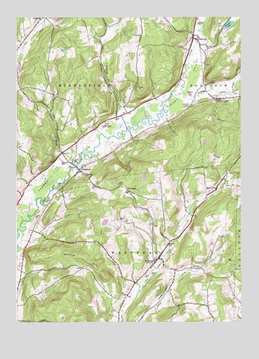
Westford, NY USGS Topographic Map
Click on map above to begin viewing in our Map Viewer.

This topographic map contains these locations and features:
Feature Name Type Latitude Longitude GNIS ID View Map
Belvedere LakeLakeN42.7470°W74.7565°943644View Map
Belvedere Lake ResortLocaleN42.7449°W74.7562°2598946View Map
Darling HillSummitN42.6492°W74.8332°948038View Map
Draper Hill CemeteryCemeteryN42.6473°W74.7731°2558746View Map
Five PointsPopulated PlaceN42.6787°W74.8127°972477View Map
Hubbel HollowValleyN42.7113°W74.8184°953361View Map
Maple ValleyPopulated PlaceN42.6795°W74.7640°956449View Map
MiddlefieldPopulated PlaceN42.6873°W74.8399°957147View Map
Middlefield CemeteryCemeteryN42.6893°W74.8376°2558743View Map
Middlefield Volunteer Fire DepartmentBuildingN42.6877°W74.8398°2735152View Map
O'Connell BrookStreamN42.6909°W74.8427°959083View Map
Pleasant BrookStreamN42.7187°W74.7882°960703View Map
Pleasant BrookPopulated PlaceN42.7165°W74.7635°970486View Map
RoseboomPopulated PlaceN42.7417°W74.7765°962915View Map
Roseboom CemeteryCemeteryN42.7420°W74.7740°2558744View Map
Roseboom Post OfficePost OfficeN42.7414°W74.7764°2598934View Map
Saint Timothy Episcopal ChurchChurchN42.6505°W74.7973°2598301View Map
School Number 10 (historical)SchoolN42.7429°W74.8257°974946View Map
School Number 7 (historical)SchoolN42.7429°W74.8688°975538View Map
School Number 8 (historical)SchoolN42.7448°W74.8051°975589View Map
Shellrock CreekStreamN42.7012°W74.8213°970600View Map
Snyder CreekStreamN42.7192°W74.7540°965595View Map
Town of MiddlefieldCivilN42.7016°W74.8695°979214View Map
Town of WestfordCivilN42.6409°W74.8165°979622View Map
Wasted AcresLocaleN42.7111°W74.8611°2557730View Map
WestfordPopulated PlaceN42.6501°W74.7977°970919View Map
Westford CemeteryCemeteryN42.6568°W74.7914°2558745View Map
Westford Volunteer Fire DepartmentBuildingN42.6529°W74.7941°2735175View Map
Winnie HollowValleyN42.7192°W74.7538°971500View Map

Note: Coordinates in the location and feature list above are referenced to NAD83 datum.


Copyright (C) 2008-2024 Ryan Niemi / Sunset Dynamics ... All Rights Reserved