TopoQuest Logo
Do you find TopoQuest useful?
Help keep TopoQuest running and adding new maps/features by donating!
Bitcoin:  19c7KJd3qBynnjoSw5npx9KScwjBe4ifkT
Litecoin:  LXs6TkuXGGXo1vDsWCkWVdjQX94eUKd6ui
Home View Maps Find Maps Find Places Resources & Links


West Franklin, Indiana Topographic Map

USGS Map Title: West Franklin, IN
USGS Map MRC: 37087H6
DRG (GeoTIFF) Download: o37087h6.tif


Neighboring USGS Topographic Map Quads:


  Wadesville, IN  
38087A7
 

  Kasson, IN  
38087A6
 

  Evansville North, IN  
38087A5
 

  Caborn, IN  
37087H7
 

  West Franklin, IN  
37087H6
 

  Evansville South, IN  
37087H5
 

  Smith Mills, KY  
37087G7
 

  Wilson, KY  
37087G6
 

  Henderson, KY  
37087G5


Map MRC Location:

N38°
W88°
N38°
W87°
H8 H7 H6 H5 H4 H3 H2 H1
G8 G7 G6 G5 G4 G3 G2 G1
F8 F7 F6 F5 F4 F3 F2 F1
E8 E7 E6 E5 E4 E3 E2 E1
D8 D7 D6 D5 D4 D3 D2 D1
C8 C7 C6 C5 C4 C3 C2 C1
B8 B7 B6 B5 B4 B3 B2 B1
A8 A7 A6 A5 A4 A3 A2 A1
N37°
W88°
N37°
W87°

West Franklin, IN USGS 1:24K Topographic Map Preview:
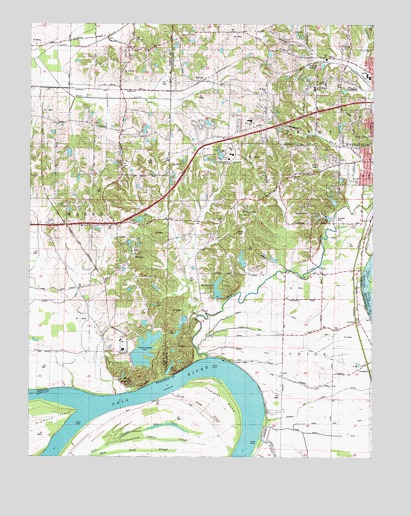
West Franklin, IN USGS Topographic Map
Click on map above to begin viewing in our Map Viewer.

This topographic map contains these locations and features:
Feature Name Type Latitude Longitude GNIS ID View Map
Barnett DitchCanalN37.9059°W87.6670°430513View Map
Bayou CreekStreamN37.9039°W87.6847°430595View Map
BelknapPopulated PlaceN37.9834°W87.6881°430752View Map
Big PondLakeN37.8844°W87.6993°487228View Map
Boehne Hospital (historical)HospitalN37.9881°W87.6461°431282View Map
Burdette ParkParkN37.9437°W87.6370°446885View Map
Camp Duesner DitchCanalN37.8962°W87.6514°432029View Map
Carpentier CreekStreamN37.9489°W87.6250°432164View Map
Corpus Christi SchoolSchoolN37.9831°W87.6428°432991View Map
CypressPopulated PlaceN37.9142°W87.6297°433608View Map
Cypress BendBendN37.8917°W87.6784°490520View Map
Cypress Dale DitchCanalN37.9070°W87.6536°433275View Map
Cypress DitchCanalN37.9192°W87.7384°433276View Map
Cypress SloughStreamN37.8795°W87.7181°490531View Map
Dove ChapelChurchN37.9423°W87.6311°433655View Map
Edmond DitchCanalN37.9162°W87.6609°434026View Map
Franklin SchoolSchoolN37.9050°W87.7236°434776View Map
Goose Pond DitchStreamN37.8831°W87.6534°1964740View Map
Goose Pond DitchCanalN37.8848°W87.6403°435209View Map
Helfrich and Hoppe DitchCanalN37.8928°W87.6389°435989View Map
HeuslerPopulated PlaceN37.9337°W87.7128°436079View Map
Horse Pond SloughGutN37.8889°W87.6867°494589View Map
Indiana State University LakeReservoirN37.9623°W87.6806°447603View Map
Indiana State University Lake DamDamN37.9612°W87.6806°447602View Map
Lawrence SchoolSchoolN37.9387°W87.7178°437673View Map
Lloyd Hahn LakeReservoirN37.9320°W87.6726°447756View Map
Lloyd Hahn Lake DamDamN37.9298°W87.6717°447757View Map
Marrs Township Volunteer Fire DepartmentBuildingN37.9921°W87.7133°2626369View Map
Martin SchoolSchoolN37.9678°W87.7172°438678View Map
Mud CenterPopulated PlaceN37.9559°W87.6286°439796View Map
Perry Heights Elementary and Junior High SchoolSchoolN37.9820°W87.6464°441030View Map
Perry Township Volunteer Fire Department Station 1BuildingN37.9596°W87.6317°2626538View Map
Perry Township Volunteer Fire Department Station 2BuildingN37.9792°W87.6620°2626539View Map
Philip StationPopulated PlaceN37.9817°W87.7420°452117View Map
Putman CemeteryCemeteryN37.9942°W87.6347°441672View Map
Rahm Vickery DitchCanalN37.8820°W87.6420°441732View Map
Red BankPopulated PlaceN37.9714°W87.6259°441815View Map
Saint Marks ChurchChurchN37.9803°W87.6642°442677View Map
Saint Pauls ChurchChurchN37.9592°W87.7170°442769View Map
Saint Peters ChurchChurchN37.9959°W87.7120°442804View Map
Saint PhilipPopulated PlaceN37.9870°W87.7159°449726View Map
Salem ChurchChurchN37.9348°W87.7114°442901View Map
Servel LakeLakeN37.9006°W87.6986°443217View Map
Slim Pond SloughStreamN37.8756°W87.7278°503694View Map
Township of PerryCivilN37.9674°W87.6568°453726View Map
Township of UnionCivilN37.8774°W87.6382°453937View Map
Twin LakeLakeN37.9191°W87.7044°445014View Map
University of Southern IndianaSchoolN37.9624°W87.6760°446884View Map
VaughanPopulated PlaceN37.9014°W87.6303°445235View Map
West FranklinPopulated PlaceN37.8950°W87.7128°445765View Map
West Terrace Elementary and Junior High SchoolSchoolN37.9723°W87.6695°445814View Map
William Hamilton LakeReservoirN37.9140°W87.6941°448883View Map
William Hamilton Lake DamDamN37.9153°W87.6934°448882View Map
Wolf CreekStreamN37.9900°W87.7481°446235View Map
Woodland LakeReservoirN37.9214°W87.6821°446287View Map
Woodland Lake DamDamN37.9217°W87.6817°447904View Map

Note: Coordinates in the location and feature list above are referenced to NAD83 datum.


Copyright (C) 2008-2024 Ryan Niemi / Sunset Dynamics ... All Rights Reserved