TopoQuest Logo
Do you find TopoQuest useful?
Help keep TopoQuest running and adding new maps/features by donating!
Bitcoin:  19c7KJd3qBynnjoSw5npx9KScwjBe4ifkT
Litecoin:  LXs6TkuXGGXo1vDsWCkWVdjQX94eUKd6ui
Home View Maps Find Maps Find Places Resources & Links


Wellston, Michigan Topographic Map

USGS Map Title: Wellston, MI
USGS Map MRC: 44085B8
DRG (GeoTIFF) Download: o44085b8.tif


Neighboring USGS Topographic Map Quads:


  Marilla, MI  
44085C8
 

  Yuma, MI  
44085C7
 

  Udell, MI  
44086B1
 

  Wellston, MI  
44085B8
 

  Wellston NE, MI  
44085B7
 

  Millerton, MI  
44086A1
 

  Peacock, MI  
44085A8
 

  Stewart Lake, MI  
44085A7


Map MRC Location:

N45°
W86°
N45°
W85°
H8 H7 H6 H5 H4 H3 H2 H1
G8 G7 G6 G5 G4 G3 G2 G1
F8 F7 F6 F5 F4 F3 F2 F1
E8 E7 E6 E5 E4 E3 E2 E1
D8 D7 D6 D5 D4 D3 D2 D1
C8 C7 C6 C5 C4 C3 C2 C1
B8 B7 B6 B5 B4 B3 B2 B1
A8 A7 A6 A5 A4 A3 A2 A1
N44°
W86°
N44°
W85°

Wellston, MI USGS 1:24K Topographic Map Preview:
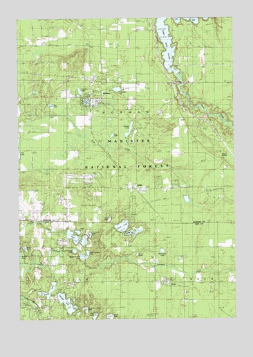
Wellston, MI USGS Topographic Map
Click on map above to begin viewing in our Map Viewer.

This topographic map contains these locations and features:
Feature Name Type Latitude Longitude GNIS ID View Map
Bear Wallow CreekStreamN44.2097°W85.9753°2359653View Map
Chittenden LakeLakeN44.2205°W85.9426°1619498View Map
Cool LakeLakeN44.1588°W85.9667°1619570View Map
Cooley BridgeBridgeN44.2231°W85.9040°1623296View Map
Coon LakeLakeN44.1261°W85.9479°1619573View Map
Cranberry LakeLakeN44.2199°W85.9642°1619603View Map
Crystal LakeReservoirN44.2154°W85.9603°2680865View Map
Crystal Lake Township ParkParkN44.2144°W85.9617°2500097View Map
Dorner LakeLakeN44.2036°W85.9357°1619741View Map
Dorner Lake Recreation SiteParkN44.2028°W85.9334°1622771View Map
Driftwood Recreation AreaParkN44.1303°W85.9917°1622770View Map
DublinPopulated PlaceN44.1795°W85.9315°1619769View Map
Dublin CemeteryCemeteryN44.1800°W85.9372°2500382View Map
Dublin Station (historical)LocaleN44.1792°W85.9319°2499306View Map
Elbow LakeLakeN44.1349°W85.9844°1619837View Map
Fairbanks LakeLakeN44.1602°W85.9589°1619882View Map
Fawn Crest Golf CourseLocaleN44.2306°W85.9606°2499850View Map
First Church of WellstonChurchN44.2175°W85.9594°2500100View Map
Harper LakeLakeN44.1319°W85.9731°1620132View Map
Heart of the Forest RV ParkLocaleN44.2256°W85.9606°2499849View Map
Horseshoe LakeLakeN44.1297°W85.9623°1620248View Map
IronsPopulated PlaceN44.1400°W85.9159°1620328View Map
Irons CemeteryCemeteryN44.1361°W85.9039°2513392View Map
Irons Lutheran ChurchChurchN44.1389°W85.9094°2513294View Map
Irons Post OfficePost OfficeN44.1408°W85.9144°2513291View Map
Irons Station (historical)LocaleN44.1406°W85.9147°2513290View Map
Littles LakeLakeN44.1613°W85.9660°1620598View Map
Lost LakeLakeN44.2014°W85.9457°1620629View Map
Lother CemeteryCemeteryN44.1303°W85.9850°2513389View Map
Low Bridge Canoe AccessLocaleN44.2183°W85.9015°1622769View Map
Lower Pickerel LakeLakeN44.1535°W85.9681°1620643View Map
Maple LakeLakeN44.1547°W85.9969°1620703View Map
Middle Pickerel LakeLakeN44.1511°W85.9640°1620817View Map
Midget LakeLakeN44.1590°W85.9338°1620818View Map
Mud LakeLakeN44.1661°W85.9481°1620933View Map
Norman Township Fire DepartmentBuildingN44.2163°W85.9574°2626851View Map
Pine RiverStreamN44.2270°W85.9076°1621248View Map
Saint Bernard ChurchChurchN44.1408°W85.9169°2513293View Map
Sand LakeLakeN44.1635°W85.9404°1621504View Map
Sand Lake Recreation AreaParkN44.1681°W85.9295°1622772View Map
Sauble - Elk - Eden Township Fire Department Station 2BuildingN44.1403°W85.9205°2626877View Map
Seventh-Day Adventist ChurchChurchN44.1550°W85.9056°2513296View Map
Star LakeLakeN44.2137°W85.9808°1621764View Map
Stronach DamDamN44.2133°W85.8953°1621798View Map
Sucker PondLakeN44.1520°W85.9316°1622773View Map
Township of NormanCivilN44.2091°W85.9420°1626809View Map
Twin Oaks CampgroundLocaleN44.2306°W85.8911°2499847View Map
Upper Pickerel LakeLakeN44.1527°W85.9604°1622003View Map
Water Tank LakeLakeN44.1533°W85.9173°1622063View Map
WellstonPopulated PlaceN44.2170°W85.9579°1622084View Map
Wellston CemeteryCemeteryN44.2164°W85.9517°2500383View Map
Wellston Census Designated PlaceCensusN44.2179°W85.9620°2583771View Map
Wellston County LibraryBuildingN44.2186°W85.9572°2499848View Map
Wellston Elementary SchoolSchoolN44.2158°W85.9542°2500099View Map
Wellston Post OfficePost OfficeN44.2167°W85.9589°2500098View Map
Wellston Station (historical)LocaleN44.2158°W85.9581°2499845View Map
Wile LakeLakeN44.1255°W85.9566°1622165View Map

Note: Coordinates in the location and feature list above are referenced to NAD83 datum.


Copyright (C) 2008-2024 Ryan Niemi / Sunset Dynamics ... All Rights Reserved