TopoQuest Logo
Do you find TopoQuest useful?
Help keep TopoQuest running and adding new maps/features by donating!
Bitcoin:  19c7KJd3qBynnjoSw5npx9KScwjBe4ifkT
Litecoin:  LXs6TkuXGGXo1vDsWCkWVdjQX94eUKd6ui
Home View Maps Find Maps Find Places Resources & Links


Wellborn, Florida Topographic Map

USGS Map Title: Wellborn, FL
USGS Map MRC: 30082B7
DRG (GeoTIFF) Download: o30082b7.tif


Neighboring USGS Topographic Map Quads:


  Live Oak East, FL  
30082C8
 

  White Springs West, FL  
30082C7
 

  White Springs East, FL  
30082C6
 

  McAlpin, FL  
30082B8
 

  Wellborn, FL  
30082B7
 

  Lake City West, FL  
30082B6
 

  O'Brien, FL  
30082A8
 

  O'Brien SE, FL  
30082A7
 

  Columbia, FL  
30082A6


Map MRC Location:

N31°
W83°
N31°
W82°
H8 H7 H6 H5 H4 H3 H2 H1
G8 G7 G6 G5 G4 G3 G2 G1
F8 F7 F6 F5 F4 F3 F2 F1
E8 E7 E6 E5 E4 E3 E2 E1
D8 D7 D6 D5 D4 D3 D2 D1
C8 C7 C6 C5 C4 C3 C2 C1
B8 B7 B6 B5 B4 B3 B2 B1
A8 A7 A6 A5 A4 A3 A2 A1
N30°
W83°
N30°
W82°

Wellborn, FL USGS 1:24K Topographic Map Preview:
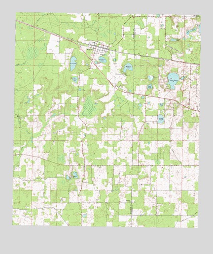
Wellborn, FL USGS Topographic Map
Click on map above to begin viewing in our Map Viewer.

This topographic map contains these locations and features:
Feature Name Type Latitude Longitude GNIS ID View Map
Bell LakeReservoirN30.2077°W82.7836°278424View Map
Bell PrairieFlatN30.2136°W82.7818°278431View Map
Bethea LakeReservoirN30.2188°W82.7986°278524View Map
Bethel Missionary Baptist ChurchChurchN30.2113°W82.8131°2452705View Map
Classy PondReservoirN30.2214°W82.8202°280502View Map
Crab CreekStreamN30.1774°W82.8621°280970View Map
Fellowship ChurchChurchN30.1402°W82.7948°282409View Map
Grace ChurchChurchN30.2144°W82.7996°283252View Map
Grissom HoleLakeN30.2258°W82.8141°283458View Map
Indian PondReservoirN30.2353°W82.7683°284526View Map
Johns PondReservoirN30.2407°W82.7568°284858View Map
King ChapelChurchN30.1963°W82.8662°285105View Map
Long PondReservoirN30.1885°W82.7763°286067View Map
Low LakeReservoirN30.2207°W82.8357°286159View Map
McClellan CemeteryCemeteryN30.2163°W82.8312°286574View Map
McClellan LakeLakeN30.2114°W82.8341°286576View Map
Mount Beulah ChurchChurchN30.1541°W82.8348°287204View Map
Mount Olive ChurchChurchN30.1886°W82.8704°287262View Map
Mount Olive ChurchChurchN30.2319°W82.8104°287263View Map
Mount Pleasant ChurchChurchN30.2077°W82.8035°287299View Map
Mount Zion ChurchChurchN30.2494°W82.7523°287351View Map
Ogden LakeReservoirN30.2119°W82.7681°288059View Map
Sand PondReservoirN30.1972°W82.7762°290578View Map
Suwannee Correctional InstitutionBuildingN30.2377°W82.8682°2753051View Map
Suwannee Correctional Institution AnnexBuildingN30.2353°W82.8682°2753052View Map
WellbornPopulated PlaceN30.2311°W82.8196°293018View Map
Wellborn AirportAirportN30.2466°W82.7790°309959View Map
Wellborn CemeteryCemeteryN30.2188°W82.8248°301612View Map
Wellborn LakeLakeN30.2231°W82.8159°293019View Map
Wellborn Post OfficePost OfficeN30.2306°W82.8201°2783429View Map
Wellborn Volunteer Fire Department Station 1BuildingN30.2301°W82.8202°2644245View Map
Wellborn Volunteer Fire Department Station 2BuildingN30.2332°W82.8216°2644156View Map

Note: Coordinates in the location and feature list above are referenced to NAD83 datum.


Copyright (C) 2008-2024 Ryan Niemi / Sunset Dynamics ... All Rights Reserved