TopoQuest Logo
Do you find TopoQuest useful?
Help keep TopoQuest running and adding new maps/features by donating!
Bitcoin:  19c7KJd3qBynnjoSw5npx9KScwjBe4ifkT
Litecoin:  LXs6TkuXGGXo1vDsWCkWVdjQX94eUKd6ui
Home View Maps Find Maps Find Places Resources & Links


Well Spring, Tennessee Topographic Map

USGS Map Title: Well Spring, TN
USGS Map MRC: 36083D8
DRG (GeoTIFF) Download: o36083d8.tif


Neighboring USGS Topographic Map Quads:


  Jellico East, TN  
36084E1
 

  Eagan, TN  
36083E8
 

  Fork Ridge, TN  
36083E7
 

  La Follette, TN  
36084D1
 

  Well Spring, TN  
36083D8
 

  Ausmus, TN  
36083D7
 

  Demory, TN  
36084C1
 

  White Hollow, TN  
36083C8
 

  Maynardville, TN  
36083C7


Map MRC Location:

N37°
W84°
N37°
W83°
H8 H7 H6 H5 H4 H3 H2 H1
G8 G7 G6 G5 G4 G3 G2 G1
F8 F7 F6 F5 F4 F3 F2 F1
E8 E7 E6 E5 E4 E3 E2 E1
D8 D7 D6 D5 D4 D3 D2 D1
C8 C7 C6 C5 C4 C3 C2 C1
B8 B7 B6 B5 B4 B3 B2 B1
A8 A7 A6 A5 A4 A3 A2 A1
N36°
W84°
N36°
W83°

Well Spring, TN USGS 1:24K Topographic Map Preview:
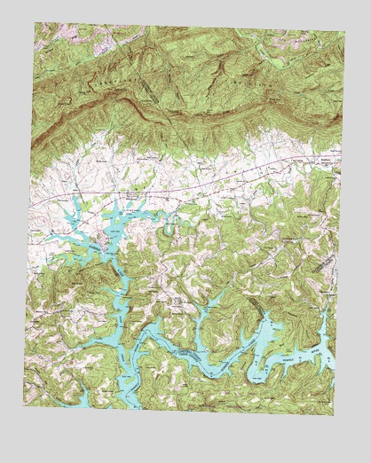
Well Spring, TN USGS Topographic Map
Click on map above to begin viewing in our Map Viewer.

This topographic map contains these locations and features:
Feature Name Type Latitude Longitude GNIS ID View Map
Altizer HollowValleyN36.4873°W83.9003°1275642View Map
Alum Cave HollowValleyN36.4895°W83.9241°1275650View Map
Backbone HollowValleyN36.4929°W83.9156°1310681View Map
Bailey CemeteryCemeteryN36.4095°W83.9405°1276105View Map
Bailey KnobSummitN36.4056°W83.9388°1276115View Map
Bee Ridge HollowValleyN36.4911°W83.8923°1310683View Map
Beeler CemeteryCemeteryN36.4570°W83.8899°1276872View Map
BethlehemPopulated PlaceN36.4065°W83.9858°1647483View Map
Bethlehem Baptist ChurchChurchN36.4126°W83.9696°1305177View Map
Bethlehem CemeteryCemeteryN36.4062°W83.9863°1318823View Map
Bethlehem SchoolSchoolN36.4059°W83.9908°1305180View Map
Big CliffCliffN36.4717°W83.8769°1277271View Map
Blue Spring HollowValleyN36.3975°W83.8799°1305313View Map
Blue Springs Hollow DockLocaleN36.4065°W83.8791°1320389View Map
Bowman CemeteryCemeteryN36.3801°W83.9030°1278075View Map
Bowman CemeteryCemeteryN36.4548°W83.9683°1278076View Map
Boyd CemeteryCemeteryN36.4320°W83.9988°1278109View Map
BradenPopulated PlaceN36.4176°W83.8755°1647527View Map
Braden CemeteryCemeteryN36.4151°W83.8774°1278149View Map
Braden SchoolSchoolN36.4148°W83.8758°1305378View Map
Brassfield BendBendN36.3926°W83.9102°1278246View Map
Brewer CemeteryCemeteryN36.3954°W83.8949°1278295View Map
Cave Spring CemeteryCemeteryN36.3795°W83.8755°1305740View Map
Cave Spring Church (historical)ChurchN36.3798°W83.8757°1320392View Map
Cawood BranchStreamN36.4559°W83.8813°1279976View Map
Cawood SchoolSchoolN36.4523°W83.8769°1279979View Map
Cawood United Methodist ChurchChurchN36.4573°W83.8788°1305748View Map
Chestnut RidgeRidgeN36.4867°W83.8846°1280418View Map
Childress CemeteryCemeteryN36.4126°W83.9694°1280456View Map
Childress CemeteryCemeteryN36.4562°W83.9516°1280457View Map
Childress GapGapN36.4792°W83.9671°1305898View Map
Clay GapGapN36.4990°W83.9738°1280630View Map
Davis CreekStreamN36.3879°W83.9571°1282179View Map
Doakes CreekStreamN36.4462°W83.9835°1306355View Map
Doakes Creek DamDamN36.4393°W83.9799°1302587View Map
Doakes PondReservoirN36.4415°W83.9808°1302586View Map
Dossett CemeteryCemeteryN36.4184°W83.9974°1282668View Map
Dossett CreekStreamN36.4248°W83.9669°1282669View Map
Dry BranchStreamN36.4390°W83.9555°1282865View Map
Dykes CemeteryCemeteryN36.4101°W83.9477°1283271View Map
Ellison CemeteryCemeteryN36.4098°W83.8813°1283701View Map
Flat HollowPopulated PlaceN36.4106°W83.9388°1647487View Map
Flat HollowValleyN36.3945°W83.9287°1284400View Map
Flat Hollow Boat DockLocaleN36.4034°W83.9313°1318851View Map
Flat Hollow CemeteryCemeteryN36.4087°W83.9282°1284402View Map
Flat Hollow ChurchChurchN36.4106°W83.9377°1284403View Map
Flat Hollow ChurchChurchN36.4404°W83.8827°1284404View Map
Flat Hollow SchoolSchoolN36.4112°W83.9369°1284405View Map
Frazier HollowValleyN36.4528°W83.9491°1284860View Map
Fullerton BendBendN36.3967°W83.8983°1285022View Map
Goins CemeteryCemeteryN36.4023°W83.9980°1285577View Map
Goins CemeteryCemeteryN36.4037°W83.9660°1285578View Map
Green CemeteryCemeteryN36.4134°W83.9463°1286083View Map
Green CemeteryCemeteryN36.4484°W83.9966°1318858View Map
Greens Ford (historical)CrossingN36.3912°W83.9296°1311300View Map
Guy CemeteryCemeteryN36.4406°W83.8830°1286460View Map
Hayes CemeteryCemeteryN36.4651°W83.9710°1287217View Map
Henegar BendBendN36.4001°W83.9510°1647530View Map
Henegar CemeteryCemeteryN36.3831°W83.9363°1287413View Map
Herring CoveValleyN36.4790°W83.9805°1287503View Map
High KnobSummitN36.4145°W83.9799°1287699View Map
Jones CemeteryCemeteryN36.3881°W83.9760°1289757View Map
Koker KnobSummitN36.4720°W83.9877°1290404View Map
Leach CemeteryCemeteryN36.4037°W83.9524°1290856View Map
Lemarr CemeteryCemeteryN36.4287°W83.9005°1291011View Map
Little CreekStreamN36.4381°W83.9441°1291453View Map
Log MountainSummitN36.4973°W83.9939°1269755View Map
Long Hollow (historical)Populated PlaceN36.3765°W83.9119°1311791View Map
Long Hollow School (historical)SchoolN36.3773°W83.9235°1320408View Map
Maupin CemeteryCemeteryN36.4512°W83.9746°1318882View Map
Maxwell CemeteryCemeteryN36.4356°W83.9396°1292981View Map
McLean RockPillarN36.4717°W83.9296°1293402View Map
McNeely CemeteryCemeteryN36.3803°W83.9685°1293440View Map
McNew CemeteryCemeteryN36.4384°W83.9227°1293445View Map
Meadow BranchStreamN36.4940°W83.8849°1293490View Map
Miller CemeteryCemeteryN36.4423°W83.9844°1293934View Map
No Business HollowValleyN36.4984°W83.9544°1295782View Map
Norton HollowValleyN36.4981°W83.8764°1295988View Map
Owens-Claiborne CemeteryCemeteryN36.4445°W83.9746°1318898View Map
Parker CemeteryCemeteryN36.3901°W83.9871°1318899View Map
Parrott CemeteryCemeteryN36.4245°W83.9885°1296885View Map
Phebe (historical)Populated PlaceN36.3965°W83.8791°1311801View Map
Pine Grove ChurchChurchN36.4151°W83.9458°1297534View Map
Powder Mill HollowValleyN36.4792°W83.8909°1310723View Map
Powder Mill HollowValleyN36.3754°W83.9758°1298385View Map
Powell Valley Conservation League CampLocaleN36.4381°W83.9619°1318907View Map
Powell Valley Resort and MarinaLocaleN36.4251°W83.9694°1318908View Map
Roger HollowValleyN36.3906°W83.9327°1647533View Map
Rogers CemeteryCemeteryN36.4540°W83.9260°1299998View Map
Rogers DockLocaleN36.4254°W83.9685°1300013View Map
Saltpeter HollowValleyN36.4941°W83.9624°1300612View Map
Sandlick RidgeRidgeN36.4926°W83.9891°1300720View Map
Seals CemeteryCemeteryN36.4298°W83.9407°1318915View Map
Shelby CemeteryCemeteryN36.3887°W83.9466°1269982View Map
Slickrock HollowValleyN36.4812°W83.8849°1310728View Map
Smith CemeteryCemeteryN36.4453°W83.9816°1318917View Map
Smith CemeteryCemeteryN36.4559°W83.9302°1318918View Map
Smith CemeteryCemeteryN36.4484°W83.9844°1318919View Map
Smith CemeteryCemeteryN36.4367°W83.9966°1318920View Map
Smith CemeteryCemeteryN36.4253°W83.9849°1270642View Map
Smith CemeteryCemeteryN36.4570°W83.9485°1270646View Map
Speedwell AcademySchoolN36.4448°W83.9174°1270972View Map
Speedwell Academy Baptist ChurchChurchN36.4445°W83.9177°1644820View Map
Speedwell Freewill Baptist ChurchChurchN36.4565°W83.8791°1644821View Map
Speedwell Post OfficePost OfficeN36.4588°W83.8792°1270974View Map
Speedwell Volunteer Fire Department Station 2BuildingN36.4483°W83.9172°2654769View Map
Standing StoneSummitN36.4995°W83.8930°1271227View Map
Stockville (historical)Populated PlaceN36.4287°W83.9849°1311316View Map
Stout KnobSummitN36.4745°W83.9527°1271548View Map
Sweat CemeteryCemeteryN36.4106°W83.9605°1271955View Map
Upper Flat Hollow SchoolSchoolN36.4317°W83.8913°1273297View Map
Well SpringLocaleN36.4442°W83.9594°1304440View Map
Well Spring CemeteryCemeteryN36.4390°W83.9602°1304441View Map
Well Springs Church of GodChurchN36.4429°W83.9371°1274094View Map
Well Springs School (historical)SchoolN36.4451°W83.9588°1318939View Map
Well Springs United Methodist ChurchChurchN36.4451°W83.9596°1953714View Map
White Oak BranchStreamN36.4962°W83.9085°1274388View Map
Wilson GapPopulated PlaceN36.4529°W83.9035°1310734View Map
Wilson GapGapN36.4770°W83.9049°1274829View Map
Wilson Gap HollowValleyN36.4805°W83.8999°1310735View Map
Wolfpen HollowValleyN36.4968°W83.9113°1274999View Map
Wright CemeteryCemeteryN36.4395°W83.8919°1275172View Map
Yellow Cliff HollowValleyN36.4901°W83.9057°1275274View Map

Note: Coordinates in the location and feature list above are referenced to NAD83 datum.


Copyright (C) 2008-2024 Ryan Niemi / Sunset Dynamics ... All Rights Reserved