TopoQuest Logo
Do you find TopoQuest useful?
Help keep TopoQuest running and adding new maps/features by donating!
Bitcoin:  19c7KJd3qBynnjoSw5npx9KScwjBe4ifkT
Litecoin:  LXs6TkuXGGXo1vDsWCkWVdjQX94eUKd6ui
Home View Maps Find Maps Find Places Resources & Links


Bonifay, Florida Topographic Map

USGS Map Title: Bonifay, FL
USGS Map MRC: 30085G6
DRG (GeoTIFF) Download: o30085g6.tif


Neighboring USGS Topographic Map Quads:


  Izagora, FL  
30085H7
 

  Esto, FL  
30085H6
 

  Graceville, FL  
30085H5
 

  Caryville, FL  
30085G7
 

  Bonifay, FL  
30085G6
 

  Chipley, FL  
30085G5
 

  Hinsons Crossroads, FL  
30085F7
 

  Poplar Head, FL  
30085F6
 

  Wausau, FL  
30085F5


Map MRC Location:

N31°
W86°
N31°
W85°
H8 H7 H6 H5 H4 H3 H2 H1
G8 G7 G6 G5 G4 G3 G2 G1
F8 F7 F6 F5 F4 F3 F2 F1
E8 E7 E6 E5 E4 E3 E2 E1
D8 D7 D6 D5 D4 D3 D2 D1
C8 C7 C6 C5 C4 C3 C2 C1
B8 B7 B6 B5 B4 B3 B2 B1
A8 A7 A6 A5 A4 A3 A2 A1
N30°
W86°
N30°
W85°

Bonifay, FL USGS 1:24K Topographic Map Preview:
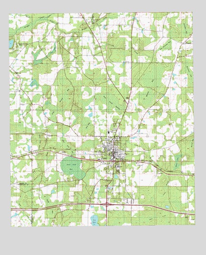
Bonifay, FL USGS Topographic Map
Click on map above to begin viewing in our Map Viewer.

This topographic map contains these locations and features:
Feature Name Type Latitude Longitude GNIS ID View Map
Bear BaySwampN30.8143°W85.6997°278283View Map
Black LakeSwampN30.7870°W85.6368°278917View Map
BonifayPopulated PlaceN30.7919°W85.6797°279203View Map
Bonifay DivisionCivilN30.8440°W85.7203°1935698View Map
Bonifay Elementary SchoolSchoolN30.8049°W85.6827°298498View Map
Bonifay Fire and RescueBuildingN30.7849°W85.6803°2644122View Map
Bonifay Police DepartmentBuildingN30.7849°W85.6802°2754522View Map
Bonifay Post OfficePost OfficeN30.7888°W85.6831°2759156View Map
Camp BranchStreamN30.7585°W85.6466°279875View Map
City of BonifayCivilN30.7827°W85.6846°2403892View Map
Doctors Memorial HospitalHospitalN30.7606°W85.6832°2094835View Map
Doctors Memorial Hospital HeliportAirportN30.7852°W85.6783°309283View Map
Gully Springs ChurchChurchN30.7932°W85.7319°283520View Map
Gum BranchGutN30.8552°W85.6672°283522View Map
Gum Creek SwampSwampN30.8219°W85.6814°283536View Map
Harrell BaySwampN30.7974°W85.6259°283755View Map
Hillcrest Special Education SchoolSchoolN30.7924°W85.6716°298495View Map
Holmes Correctional InstitutionBuildingN30.7558°W85.6701°2753066View Map
Holmes County Adult Education SchoolSchoolN30.7946°W85.6822°298497View Map
Holmes County Emergency Medical Services Station 1BuildingN30.7870°W85.6623°2661815View Map
Holmes County High SchoolSchoolN30.7869°W85.6952°298496View Map
Holmes County Sheriff's OfficeBuildingN30.7938°W85.6787°2754505View Map
Hoover MillPopulated PlaceN30.8696°W85.6860°295358View Map
Hurricane BaySwampN30.8405°W85.6282°284421View Map
Liberty ChurchChurchN30.8591°W85.7294°285494View Map
Little Gum CreekStreamN30.7882°W85.7316°285700View Map
Little Rock ChurchChurchN30.8569°W85.6305°285791View Map
Live Oak SchoolSchoolN30.8296°W85.7438°285886View Map
Long BaySwampN30.7615°W85.7237°285948View Map
Long Round BaySwampN30.8181°W85.7165°286073View Map
Martins BaySwampN30.8332°W85.6538°286475View Map
Meetinghouse BaySwampN30.8725°W85.6932°286680View Map
Moccasin BaySwampN30.8649°W85.6304°287031View Map
Mount Olive ChurchChurchN30.8463°W85.6688°287278View Map
Mud Path BaySwampN30.7985°W85.7141°287420View Map
New Smyrna ChurchChurchN30.8699°W85.6919°287693View Map
Pate PondSwampN30.8530°W85.7196°288567View Map
Saint Johns ChurchChurchN30.7669°W85.6949°290230View Map
Sand Path BaySwampN30.7848°W85.7077°290545View Map
Sand Ridge SchoolSchoolN30.8571°W85.6316°290583View Map
Spring Hill ChurchChurchN30.8452°W85.6858°291542View Map
Still CemeteryCemeteryN30.8307°W85.6916°300954View Map
Sun LakeReservoirN30.7528°W85.6928°291817View Map
Tenmile CreekStreamN30.8719°W85.7285°127756View Map
Tharpe AirportAirportN30.8289°W85.7287°309284View Map
Titi BranchStreamN30.8696°W85.7341°292316View Map
Tom Williams BaySwampN30.8548°W85.6435°292339View Map

Note: Coordinates in the location and feature list above are referenced to NAD83 datum.


Copyright (C) 2008-2024 Ryan Niemi / Sunset Dynamics ... All Rights Reserved