TopoQuest Logo
Do you find TopoQuest useful?
Help keep TopoQuest running and adding new maps/features by donating!
Bitcoin:  19c7KJd3qBynnjoSw5npx9KScwjBe4ifkT
Litecoin:  LXs6TkuXGGXo1vDsWCkWVdjQX94eUKd6ui
Home View Maps Find Maps Find Places Resources & Links


Boneyard Draw, Texas Topographic Map

USGS Map Title: Boneyard Draw, TX
USGS Map MRC: 30099A5
DRG (GeoTIFF) Download: o30099a5.tif


Neighboring USGS Topographic Map Quads:


  Y O Ranch, TX  
30099B6
 

  Live Oak Ranch, TX  
30099B5
 

  Contrary Creek, TX  
30099B4
 

  Garven Store, TX  
30099A6
 

  Boneyard Draw, TX  
30099A5
 

  Bee Caves Creek, TX  
30099A4
 

  Hillcrest Ranch, TX  
29099H6
 

  Well Hollow, TX  
29099H5
 

  Diamond S Ranch, TX  
29099H4


Map MRC Location:

N31°
W100°
N31°
W99°
H8 H7 H6 H5 H4 H3 H2 H1
G8 G7 G6 G5 G4 G3 G2 G1
F8 F7 F6 F5 F4 F3 F2 F1
E8 E7 E6 E5 E4 E3 E2 E1
D8 D7 D6 D5 D4 D3 D2 D1
C8 C7 C6 C5 C4 C3 C2 C1
B8 B7 B6 B5 B4 B3 B2 B1
A8 A7 A6 A5 A4 A3 A2 A1
N30°
W100°
N30°
W99°

Boneyard Draw, TX USGS 1:24K Topographic Map Preview:
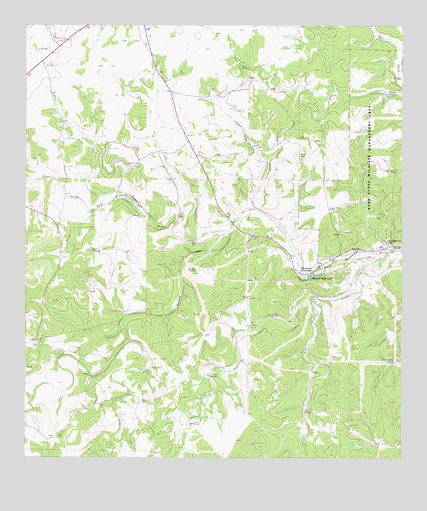
Boneyard Draw, TX USGS Topographic Map
Click on map above to begin viewing in our Map Viewer.

This topographic map contains these locations and features:
Feature Name Type Latitude Longitude GNIS ID View Map
Benson RanchLocaleN30.0163°W99.5864°1330426View Map
Bobcat WindmillLocaleN30.0722°W99.5245°1330973View Map
Boneyard DrawValleyN30.0660°W99.5564°1331042View Map
Boneyard WaterholeLakeN30.0549°W99.5337°1331043View Map
Boneyard WindmillLocaleN30.0541°W99.5712°1331044View Map
Bonnie Belle LakeLakeN30.0526°W99.5303°1331060View Map
Divide Elementary SchoolSchoolN30.1180°W99.6181°2006975View Map
Divide SchoolSchoolN30.1180°W99.6181°1334398View Map
Fish and Wildlife SpringsSpringN30.0752°W99.5087°1998491View Map
Flat Rock CreekStreamN30.0588°W99.5064°1335916View Map
Flat Rock WindmillLocaleN30.0135°W99.5320°1335922View Map
Fox WindmillLocaleN30.1096°W99.5009°1336141View Map
Indian CreekStreamN30.0722°W99.5489°1338400View Map
Kerr Wildlife Management AreaParkN30.0883°W99.5020°1339057View Map
Love WindmillLocaleN30.0941°W99.5151°1340662View Map
New WindmillLocaleN30.0463°W99.5514°1342533View Map
Red HillSummitN30.0863°W99.5345°1344927View Map
Sampson WindmillLocaleN30.0244°W99.5637°1346283View Map
South WindmillLocaleN30.0099°W99.5692°1347554View Map
South WindmillLocaleN30.1124°W99.5539°1347555View Map
Steel Tank WindmillLocaleN30.0833°W99.5045°1347852View Map
Stowers Corner WindmillPopulated PlaceN30.0280°W99.5028°1379121View Map
Stowers Ranch Airport (historical)AirportN30.0577°W99.5128°1386923View Map
Turkey LakeReservoirN30.1054°W99.5057°1348886View Map

Note: Coordinates in the location and feature list above are referenced to NAD83 datum.


Copyright (C) 2008-2024 Ryan Niemi / Sunset Dynamics ... All Rights Reserved