TopoQuest Logo
Do you find TopoQuest useful?
Help keep TopoQuest running and adding new maps/features by donating!
Bitcoin:  19c7KJd3qBynnjoSw5npx9KScwjBe4ifkT
Litecoin:  LXs6TkuXGGXo1vDsWCkWVdjQX94eUKd6ui
Home View Maps Find Maps Find Places Resources & Links


Weatherford South, Texas Topographic Map

USGS Map Title: Weatherford South, TX
USGS Map MRC: 32097F7
DRG (GeoTIFF) Download: o32097f7.tif


Neighboring USGS Topographic Map Quads:


  Garner, TX  
32097G8
 

  Weatherford North, TX  
32097G7
 

  Lake Weatherford, TX  
32097G6
 

  Brock, TX  
32097F8
 

  Weatherford South, TX  
32097F7
 

  Annetta, TX  
32097F6
 

  Dennis, TX  
32097E8
 

  Tin Top, TX  
32097E7
 

  Chapin, TX  
32097E6


Map MRC Location:

N33°
W98°
N33°
W97°
H8 H7 H6 H5 H4 H3 H2 H1
G8 G7 G6 G5 G4 G3 G2 G1
F8 F7 F6 F5 F4 F3 F2 F1
E8 E7 E6 E5 E4 E3 E2 E1
D8 D7 D6 D5 D4 D3 D2 D1
C8 C7 C6 C5 C4 C3 C2 C1
B8 B7 B6 B5 B4 B3 B2 B1
A8 A7 A6 A5 A4 A3 A2 A1
N32°
W98°
N32°
W97°

Weatherford South, TX USGS 1:24K Topographic Map Preview:
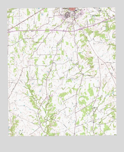
Weatherford South, TX USGS Topographic Map
Click on map above to begin viewing in our Map Viewer.

This topographic map contains these locations and features:
Feature Name Type Latitude Longitude GNIS ID View Map
Amigo for Christ Airport (historical)AirportN32.6604°W97.8423°1387727View Map
Austin Elementary SchoolSchoolN32.7346°W97.7834°2008133View Map
BethelPopulated PlaceN32.6962°W97.8228°1378000View Map
Blackwell CemeteryCemeteryN32.6423°W97.7551°1330818View Map
Buckmaster HeliportAirportN32.6271°W97.7839°1387724View Map
Campbell Health SystemHospitalN32.7476°W97.7873°2015741View Map
Campbell Memorial Hospital HeliportAirportN32.7479°W97.7845°1387721View Map
Church of Christ - WindmillChurchN32.6285°W97.7989°2023858View Map
Clear LakesLakeN32.7361°W97.7606°1332955View Map
Curtis CemeteryCemeteryN32.7446°W97.7911°1333832View Map
Curtis Elementary SchoolSchoolN32.7487°W97.8045°2008138View Map
East Sanchez CreekStreamN32.6512°W97.8331°1334986View Map
Folley BranchStreamN32.6801°W97.8067°1336002View Map
Hall Junior High SchoolSchoolN32.7487°W97.8117°2008140View Map
HarmonyPopulated PlaceN32.6951°W97.7964°1378419View Map
Harmony Baptist ChurchChurchN32.6951°W97.8161°2023841View Map
Harmony CemeteryCemeteryN32.6812°W97.8034°1337360View Map
Hill Crest CemeteryCemeteryN32.7435°W97.7909°1337780View Map
Holland Lake ParkParkN32.7421°W97.7756°2029130View Map
Holland Lake ParkLocaleN32.7421°W97.7728°1337946View Map
Houston Elementary SchoolSchoolN32.7426°W97.8178°2008141View Map
Kangaroo StadiumParkN32.7485°W97.7945°1384402View Map
Life Care Emergency Medical ServicesBuildingN32.7468°W97.7845°2655961View Map
Live Oak Country ClubLocaleN32.7362°W97.8034°1384414View Map
Parker County Constable's Office Precinct 3BuildingN32.7462°W97.7829°2739114View Map
Parker County CourthouseBuildingN32.7490°W97.7839°2030568View Map
Parker County Fire Marshal's OfficeBuildingN32.7355°W97.8025°2551399View Map
Post Oak AirfieldAirportN32.6755°W97.7836°1387720View Map
Saint Stephens Catholic ChurchChurchN32.7265°W97.8078°2023854View Map
Sam Little International Airport (historical)AirportN32.6820°W97.8065°1387725View Map
Santa Fe Drive Baptist ChurchChurchN32.7399°W97.7775°2023847View Map
Soldier Springs ParkParkN32.7460°W97.8098°2029284View Map
Spring Creek Baptist ChurchChurchN32.6521°W97.7773°2023850View Map
Spring Creek ChurchChurchN32.6521°W97.7770°1347729View Map
The Church of Jesus Christ of Latter Day SaintsChurchN32.7393°W97.8145°2023806View Map
The Double Log CabinBuildingN32.7424°W97.7748°1348444View Map
Threemile BranchStreamN32.6676°W97.8261°1348530View Map
Weatherford College Police DepartmentBuildingN32.7404°W97.7895°2739145View Map
Weatherford High SchoolSchoolN32.7482°W97.7975°2008157View Map
Weatherford Post OfficePost OfficeN32.7462°W97.7811°2731801View Map
Weatherford Regional Medical CenterHospitalN32.7484°W97.7857°1332037View Map

Note: Coordinates in the location and feature list above are referenced to NAD83 datum.


Copyright (C) 2008-2024 Ryan Niemi / Sunset Dynamics ... All Rights Reserved