TopoQuest Logo
Do you find TopoQuest useful?
Help keep TopoQuest running and adding new maps/features by donating!
Bitcoin:  19c7KJd3qBynnjoSw5npx9KScwjBe4ifkT
Litecoin:  LXs6TkuXGGXo1vDsWCkWVdjQX94eUKd6ui
Home View Maps Find Maps Find Places Resources & Links


Bonduel, Wisconsin Topographic Map

USGS Map Title: Bonduel, WI
USGS Map MRC: 44088F4
DRG (GeoTIFF) Download: o44088f4.tif


Neighboring USGS Topographic Map Quads:


  Shawano, WI  
44088G5
 

  Cecil, WI  
44088G4
 

  Krakow, WI  
44088G3
 

  Lunds, WI  
44088F5
 

  Bonduel, WI  
44088F4
 

  Zachow, WI  
44088F3
 

  Leeman, WI  
44088E5
 

  Nichols, WI  
44088E4
 

  Seymour, WI  
44088E3


Map MRC Location:

N45°
W89°
N45°
W88°
H8 H7 H6 H5 H4 H3 H2 H1
G8 G7 G6 G5 G4 G3 G2 G1
F8 F7 F6 F5 F4 F3 F2 F1
E8 E7 E6 E5 E4 E3 E2 E1
D8 D7 D6 D5 D4 D3 D2 D1
C8 C7 C6 C5 C4 C3 C2 C1
B8 B7 B6 B5 B4 B3 B2 B1
A8 A7 A6 A5 A4 A3 A2 A1
N44°
W89°
N44°
W88°

Bonduel, WI USGS 1:24K Topographic Map Preview:
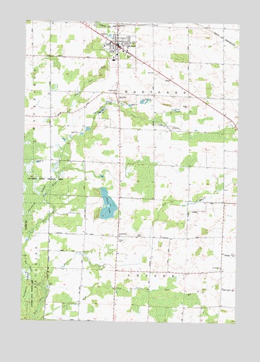
Bonduel, WI USGS Topographic Map
Click on map above to begin viewing in our Map Viewer.

This topographic map contains these locations and features:
Feature Name Type Latitude Longitude GNIS ID View Map
BonduelPopulated PlaceN44.7403°W88.4448°1562052View Map
Bonduel Area Fire DepartmentBuildingN44.7384°W88.4477°2696704View Map
Bonduel Elementary SchoolSchoolN44.7383°W88.4524°2713261View Map
Bonduel High SchoolSchoolN44.7404°W88.4531°2713397View Map
Bonduel Middle SchoolSchoolN44.7405°W88.4526°2713353View Map
Bonduel Police DepartmentBuildingN44.7382°W88.4478°2759448View Map
Cedar ParkParkN44.7442°W88.4537°1562861View Map
Church CemeteryCemeteryN44.6589°W88.4437°1563079View Map
Deer View SchoolSchoolN44.7269°W88.4863°2713288View Map
East Branch Shioc RiverStreamN44.6394°W88.4879°1564301View Map
Friedens CemeteryCemeteryN44.7214°W88.4448°1565326View Map
LandstadPopulated PlaceN44.6605°W88.4437°1567827View Map
Lessor CemeteryCemeteryN44.6608°W88.4326°1567992View Map
Our Saviors ChurchChurchN44.6478°W88.3840°1570945View Map
Saint Paul CemeteryCemeteryN44.7361°W88.4398°1573436View Map
Saint Paul Lutheran SchoolSchoolN44.7377°W88.4429°2713385View Map
Slab CityPopulated PlaceN44.7203°W88.4457°1574258View Map
Slab City CreekStreamN44.6961°W88.4768°1574259View Map
Town of HartlandCivilN44.7198°W88.4227°1583362View Map
Town of LessorCivilN44.6325°W88.4254°1583547View Map
Village of BonduelCivilN44.7383°W88.4474°1582841View Map
West Branch Shioc RiverStreamN44.6394°W88.4879°1576480View Map
White LakeLakeN44.6703°W88.4500°1576641View Map
Zion CemeteryCemeteryN44.7291°W88.4237°1577148View Map

Note: Coordinates in the location and feature list above are referenced to NAD83 datum.


Copyright (C) 2008-2024 Ryan Niemi / Sunset Dynamics ... All Rights Reserved