TopoQuest Logo
Do you find TopoQuest useful?
Help keep TopoQuest running and adding new maps/features by donating!
Bitcoin:  19c7KJd3qBynnjoSw5npx9KScwjBe4ifkT
Litecoin:  LXs6TkuXGGXo1vDsWCkWVdjQX94eUKd6ui
Home View Maps Find Maps Find Places Resources & Links


Wartrace, Tennessee Topographic Map

USGS Map Title: Wartrace, TN
USGS Map MRC: 35086E3
DRG (GeoTIFF) Download: o35086e3.tif


Neighboring USGS Topographic Map Quads:


  Fosterville, TN  
35086F4
 

  Webbs Jungle, TN  
35086F3
 

  Beechgrove, TN  
35086F2
 

  Deason, TN  
35086E4
 

  Wartrace, TN  
35086E3
 

  Noah, TN  
35086E2
 

  Shelbyville, TN  
35086D4
 

  Normandy, TN  
35086D3
 

  Normandy Lake, TN  
35086D2


Map MRC Location:

N36°
W87°
N36°
W86°
H8 H7 H6 H5 H4 H3 H2 H1
G8 G7 G6 G5 G4 G3 G2 G1
F8 F7 F6 F5 F4 F3 F2 F1
E8 E7 E6 E5 E4 E3 E2 E1
D8 D7 D6 D5 D4 D3 D2 D1
C8 C7 C6 C5 C4 C3 C2 C1
B8 B7 B6 B5 B4 B3 B2 B1
A8 A7 A6 A5 A4 A3 A2 A1
N35°
W87°
N35°
W86°

Wartrace, TN USGS 1:24K Topographic Map Preview:
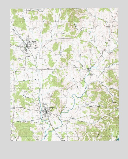
Wartrace, TN USGS Topographic Map
Click on map above to begin viewing in our Map Viewer.

This topographic map contains these locations and features:
Feature Name Type Latitude Longitude GNIS ID View Map
Anthony BranchStreamN35.5498°W86.3403°1269306View Map
Arnold CemeteryCemeteryN35.5009°W86.3433°1304875View Map
Arnold CemeteryCemeteryN35.5606°W86.3517°1275882View Map
Ault CemeteryCemeteryN35.5228°W86.3683°1319225View Map
Bates BranchStreamN35.5434°W86.3000°1276458View Map
Bates-Finch-Muse CemeteryCemeteryN35.5576°W86.3036°1319229View Map
Beachboard CemeteryCemeteryN35.6240°W86.3517°1276525View Map
Bedford Lake DamDamN35.5006°W86.2533°1307124View Map
Bell BucklePopulated PlaceN35.5917°W86.3542°1276910View Map
Bell Buckle CreekStreamN35.5784°W86.3453°1276911View Map
Bell Buckle Division (historical)CensusN35.6001°W86.3630°1648597View Map
Bell Buckle First Baptist ChurchChurchN35.5895°W86.3530°1319236View Map
Bell Buckle Historic DistrictParkN35.5895°W86.3550°1326446View Map
Bell Buckle Post OfficePost OfficeN35.5889°W86.3547°1651210View Map
Bell Buckle School (historical)SchoolN35.5862°W86.3586°1319237View Map
Bell Buckle Volunteer Fire DepartmentBuildingN35.5911°W86.3554°2653626View Map
Bethlehem CemeteryCemeteryN35.5187°W86.3080°1277154View Map
Bethsalem CemeteryCemeteryN35.5190°W86.3078°1319239View Map
Bethsalem Church (historical)ChurchN35.5187°W86.3078°1319240View Map
Blackman HollowValleyN35.6040°W86.2949°1277611View Map
Bouton CemeteryCemeteryN35.5817°W86.2589°1319247View Map
Bowmans CutLocaleN35.5179°W86.3717°1644983View Map
Cannon CemeteryCemeteryN35.5048°W86.3678°1319259View Map
Cawthron CemeteryCemeteryN35.5298°W86.2503°1319263View Map
Chambers CemeteryCemeteryN35.5467°W86.3592°1280211View Map
Cleveland CemeteryCemeteryN35.5315°W86.3114°1319270View Map
Coffee CemeteryCemeteryN35.5245°W86.3425°1280860View Map
Commissioner District 1CivilN35.5636°W86.3270°2464207View Map
Cortner CemeteryCemeteryN35.5778°W86.3667°1281335View Map
Crouch BranchStreamN35.5990°W86.3269°1281733View Map
Davidson CemeteryCemeteryN35.5109°W86.3061°1319290View Map
Davis CemeteryCemeteryN35.6098°W86.3697°1319291View Map
Davis Shop (historical)LocaleN35.6237°W86.3555°1644985View Map
Erwin CemeteryCemeteryN35.5117°W86.3053°1319307View Map
FairfieldPopulated PlaceN35.5667°W86.2853°1283975View Map
Fairfield Church of ChristChurchN35.5684°W86.2869°1310140View Map
Friendship Church (historical)ChurchN35.5476°W86.3239°1644986View Map
Gibson Chapel (historical)ChurchN35.5254°W86.2517°1319319View Map
Happy ValleyValleyN35.5938°W86.3380°1286780View Map
Hawkins BranchStreamN35.5587°W86.2897°1287172View Map
Hazel CemeteryCemeteryN35.5837°W86.3580°1287259View Map
Henry-Jarman CemeteryCemeteryN35.5520°W86.3444°1319346View Map
Hollywood CemeteryCemeteryN35.5337°W86.3372°1288122View Map
Holt CemeteryCemeteryN35.5328°W86.3508°1319355View Map
Hoover BranchStreamN35.5917°W86.3397°1288268View Map
Hord CemeteryCemeteryN35.5140°W86.2675°1319358View Map
Hords Chapel African Methodist Episcopal ChurchChurchN35.5106°W86.2678°1306586View Map
Hurricane BranchStreamN35.5406°W86.3422°1288781View Map
Justice HollowValleyN35.5328°W86.2895°1289893View Map
Keeling CemeteryCemeteryN35.5295°W86.2503°2061092View Map
Keller CemeteryCemeteryN35.5462°W86.2872°1289990View Map
KellertownPopulated PlaceN35.5340°W86.2886°1315314View Map
Kelly CreekStreamN35.5906°W86.3392°1290032View Map
Knob CreekStreamN35.5184°W86.3161°1269707View Map
Larkins Store (historical)LocaleN35.6190°W86.3172°1644991View Map
Lee BranchStreamN35.5834°W86.2605°1290938View Map
Lee CemeteryCemeteryN35.5156°W86.3380°1290945View Map
Lynch BranchStreamN35.6037°W86.2872°1292332View Map
Manley CemeteryCemeteryN35.6237°W86.3403°1319397View Map
Martin CemeteryCemeteryN35.5995°W86.2636°1319399View Map
McMahan CemeteryCemeteryN35.5853°W86.2980°1319409View Map
Morgan BranchStreamN35.5629°W86.2850°1294348View Map
Morgan LakeReservoirN35.5034°W86.3664°1301876View Map
Morgan Lake DamDamN35.5021°W86.3666°1301877View Map
Murphy CemeteryCemeteryN35.5020°W86.3169°1295115View Map
Muse BranchStreamN35.5573°W86.3369°1295162View Map
Muse CemeteryCemeteryN35.5665°W86.3269°1295164View Map
New Hope Baptist ChurchChurchN35.5634°W86.2828°1295530View Map
New Hope CemeteryCemeteryN35.5631°W86.2828°1319426View Map
Noah ForkStreamN35.5687°W86.2758°1295789View Map
Norvell CemeteryCemeteryN35.5856°W86.3469°1319431View Map
Old Salem CemeteryCemeteryN35.5795°W86.3569°1296365View Map
Pannell BranchStreamN35.5192°W86.3511°1296715View Map
Parker SpringSpringN35.6242°W86.3439°1296836View Map
Peacock CemeteryCemeteryN35.5901°W86.3539°1319448View Map
Phillips CemeteryCemeteryN35.5220°W86.3622°1319452View Map
Pruitt CemeteryCemeteryN35.5484°W86.3733°1319462View Map
Puncheon Camp CreekStreamN35.5915°W86.2517°1269880View Map
Puncheon Camp HollowValleyN35.6237°W86.2869°1298695View Map
Puncheon Camp SchoolSchoolN35.6170°W86.2783°1298696View Map
Salem Church (historical)ChurchN35.5795°W86.3572°1644994View Map
Sallie BranchStreamN35.5795°W86.2683°1300575View Map
Shaw CemeteryCemeteryN35.6092°W86.2514°1319479View Map
Shelton CemeteryCemeteryN35.5606°W86.2511°1319485View Map
ShilohPopulated PlaceN35.5304°W86.2511°1314277View Map
Shiloh CemeteryCemeteryN35.5301°W86.2519°1319486View Map
Shiloh Church (historical)ChurchN35.5301°W86.2525°1319487View Map
Shiloh School (historical)SchoolN35.5301°W86.2530°1319488View Map
Stokes BranchStreamN35.5067°W86.3344°1271463View Map
Straight CreekStreamN35.5529°W86.2867°1271569View Map
Sunnyside Church (historical)ChurchN35.5651°W86.3697°1319513View Map
Town of Bell BuckleCivilN35.5900°W86.3530°2405232View Map
Town of WartraceCivilN35.5276°W86.3327°2406834View Map
Union Meeting House (historical)ChurchN35.5112°W86.3061°1319537View Map
Union RidgePopulated PlaceN35.5104°W86.2647°1314435View Map
Union Ridge Church of God in ChristChurchN35.5148°W86.2617°1310159View Map
Union Ridge School (historical)SchoolN35.5098°W86.2647°1319538View Map
Vance CemeteryCemeteryN35.5092°W86.2508°1319543View Map
Waite-Friendship CemeteryCemeteryN35.5476°W86.3242°1319546View Map
Wallis CemeteryCemeteryN35.5634°W86.3711°1319547View Map
WartracePopulated PlaceN35.5273°W86.3336°1304389View Map
Wartrace Baptist ChurchChurchN35.5284°W86.3308°1319551View Map
Wartrace CemeteryCemeteryN35.5198°W86.3314°1273845View Map
Wartrace CreekStreamN35.5406°W86.3422°1273847View Map
Wartrace Division (historical)CensusN35.5229°W86.3167°1648601View Map
Wartrace Police DepartmentBuildingN35.5276°W86.3331°2765925View Map
Wartrace Post OfficePost OfficeN35.5240°W86.3343°1651236View Map
Wartrace SchoolSchoolN35.5284°W86.3364°1319552View Map
Wartrace SchoolSchoolN35.5304°W86.3311°1319553View Map
Wartrace Volunteer Fire DepartmentBuildingN35.5290°W86.3336°2654161View Map
Webb SchoolSchoolN35.5881°W86.3478°1274038View Map
West CemeteryCemeteryN35.5256°W86.3522°1319558View Map

Note: Coordinates in the location and feature list above are referenced to NAD83 datum.


Copyright (C) 2008-2024 Ryan Niemi / Sunset Dynamics ... All Rights Reserved