TopoQuest Logo
Do you find TopoQuest useful?
Help keep TopoQuest running and adding new maps/features by donating!
Bitcoin:  19c7KJd3qBynnjoSw5npx9KScwjBe4ifkT
Litecoin:  LXs6TkuXGGXo1vDsWCkWVdjQX94eUKd6ui
Home View Maps Find Maps Find Places Resources & Links


Warsaw, Illinois Topographic Map

USGS Map Title: Warsaw, IL
USGS Map MRC: 40091C4
DRG (GeoTIFF) Download: o40091c4.tif


Neighboring USGS Topographic Map Quads:


  Wayland, MO  
40091D5
 

  Keokuk, IA  
40091D4
 

  Hamilton, IL  
40091D3
 

  Kahoka SE, MO  
40091C5
 

  Warsaw, IL  
40091C4
 

  Sutter, IL  
40091C3
 

  Canton, MO  
40091B5
 

  Lima, IL  
40091B4
 

  Tioga, IL  
40091B3


Map MRC Location:

N41°
W92°
N41°
W91°
H8 H7 H6 H5 H4 H3 H2 H1
G8 G7 G6 G5 G4 G3 G2 G1
F8 F7 F6 F5 F4 F3 F2 F1
E8 E7 E6 E5 E4 E3 E2 E1
D8 D7 D6 D5 D4 D3 D2 D1
C8 C7 C6 C5 C4 C3 C2 C1
B8 B7 B6 B5 B4 B3 B2 B1
A8 A7 A6 A5 A4 A3 A2 A1
N40°
W92°
N40°
W91°

Warsaw, IL USGS 1:24K Topographic Map Preview:
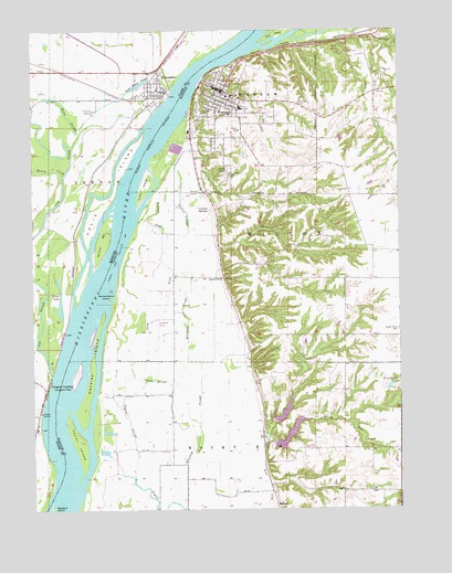
Warsaw, IL USGS Topographic Map
Click on map above to begin viewing in our Map Viewer.

This topographic map contains these locations and features:
Feature Name Type Latitude Longitude GNIS ID View Map
AlexandriaPopulated PlaceN40.3595°W91.4554°735484View Map
Alexandria Fire Protection DistrictBuildingN40.3591°W91.4570°2621695View Map
Alexandria Post OfficePost OfficeN40.3596°W91.4564°2783140View Map
Calumet SpringsSpringN40.3281°W91.4402°405382View Map
Catholic CemeteryCemeteryN40.3559°W91.4088°1720591View Map
Cedar Glen Nature PreserveParkN40.3662°W91.3968°2009646View Map
City of AlexandriaCivilN40.3597°W91.4595°2393919View Map
City of WarsawCivilN40.3509°W91.4277°2397200View Map
Copper SloughGutN40.2837°W91.4588°406570View Map
Dennis SloughGutN40.3275°W91.4474°407129View Map
Fox Island (historical)IslandN40.3114°W91.4906°731749View Map
Fox RiverStreamN40.2848°W91.4940°735621View Map
Green Plain School (historical)SchoolN40.2973°W91.3754°1720604View Map
Green Plains CemeteryCemeteryN40.2967°W91.3760°409393View Map
Gregory LandingPopulated PlaceN40.2814°W91.4963°740887View Map
Greys IslandIslandN40.3298°W91.4763°735638View Map
H Meeker Airport (historical)AirportN40.2542°W91.4402°427895View Map
Hackley ChuteGutN40.2884°W91.4784°2761280View Map
Hackley IslandIslandN40.2881°W91.4799°409593View Map
Hancock County Ambulance ServiceBuildingN40.3602°W91.4370°2640548View Map
Hemp SloughGutN40.3525°W91.4879°719363View Map
Honey CreekStreamN40.3375°W91.4890°719761View Map
Jan Knipe AirportAirportN40.3692°W91.3868°2679095View Map
Kamps-Stiens IslandIslandN40.3050°W91.4740°411292View Map
Kaufman SloughGutN40.3259°W91.4607°411329View Map
Kusie IslandIslandN40.3339°W91.4621°411625View Map
Limkemann PondReservoirN40.2900°W91.3752°1692541View Map
Limkemann Pond DamDamN40.2900°W91.3752°1692540View Map
Lingle SchoolSchoolN40.3598°W91.4568°731750View Map
Little Rocky Run LakeReservoirN40.2754°W91.4149°1691030View Map
Little Rocky Run Lake DamDamN40.2734°W91.4168°1691029View Map
Long PondGutN40.3025°W91.4563°412596View Map
Lutheran CemeteryCemeteryN40.3375°W91.4326°1720615View Map
MallardLocaleN40.2512°W91.4177°412873View Map
Mississippi River Sand Hills Nature PreserveParkN40.3673°W91.4190°2009647View Map
Mount Vernon Missionary Baptist CemeteryCemeteryN40.2834°W91.3757°414093View Map
Mud Slough (historical)LakeN40.2725°W91.4607°1720620View Map
Oakland CemeteryCemeteryN40.3395°W91.4343°414887View Map
Pickle House SloughGutN40.3606°W91.4635°724313View Map
Rockford SchoolSchoolN40.3103°W91.4357°416848View Map
Rocky RunStreamN40.2687°W91.4207°416883View Map
Rocky Run LakeReservoirN40.2696°W91.4130°1691032View Map
Rocky Run Lake DamDamN40.2684°W91.4168°1691031View Map
Rocky Run School (historical)SchoolN40.2656°W91.4096°1720628View Map
Shuhart CreekStreamN40.3406°W91.4596°418480View Map
Silver LakeLakeN40.3045°W91.4910°726451View Map
Taylor IslandIslandN40.2681°W91.4854°419564View Map
Taylor SloughGutN40.2578°W91.4660°419573View Map
Township of VernonCivilN40.3474°W91.4732°766501View Map
Township of WarsawCivilN40.3509°W91.4277°429896View Map
Township of WilcoxCivilN40.3195°W91.4173°429935View Map
WarsawPopulated PlaceN40.3592°W91.4346°420542View Map
Warsaw Airport (historical)AirportN40.3320°W91.4463°1720635View Map
Warsaw Historic DistrictParkN40.3598°W91.4357°1812514View Map
Warsaw Police DepartmentBuildingN40.3600°W91.4377°2756789View Map
Warsaw Post OfficePost OfficeN40.3591°W91.4350°2788807View Map
Warsaw Rural Fire Protection DistrictBuildingN40.3587°W91.4359°2640385View Map
White Brick School (historical)SchoolN40.3584°W91.3832°1720639View Map
White Prairie School (historical)SchoolN40.2731°W91.4535°1720640View Map
Whitney SloughGutN40.2817°W91.4499°421114View Map
Wilcox TownhallBuildingN40.3331°W91.3927°1720641View Map
Willow BarBarN40.3200°W91.4763°735919View Map

Note: Coordinates in the location and feature list above are referenced to NAD83 datum.


Copyright (C) 2008-2024 Ryan Niemi / Sunset Dynamics ... All Rights Reserved