TopoQuest Logo
Do you find TopoQuest useful?
Help keep TopoQuest running and adding new maps/features by donating!
Bitcoin:  19c7KJd3qBynnjoSw5npx9KScwjBe4ifkT
Litecoin:  LXs6TkuXGGXo1vDsWCkWVdjQX94eUKd6ui
Home View Maps Find Maps Find Places Resources & Links


Warrenton, Georgia Topographic Map

USGS Map Title: Warrenton, GA
USGS Map MRC: 33082D6
DRG (GeoTIFF) Download: o33082d6.tif


Neighboring USGS Topographic Map Quads:


  Sharon, GA  
33082E7
 

  Cadley, GA  
33082E6
 

  Wrightsboro, GA  
33082E5
 

  Sparta NE, GA  
33082D7
 

  Warrenton, GA  
33082D6
 

  Thomson West, GA  
33082D5
 

  Jewell, GA  
33082C7
 

  Beall Springs, GA  
33082C6
 

  Bastonville, GA  
33082C5


Map MRC Location:

N34°
W83°
N34°
W82°
H8 H7 H6 H5 H4 H3 H2 H1
G8 G7 G6 G5 G4 G3 G2 G1
F8 F7 F6 F5 F4 F3 F2 F1
E8 E7 E6 E5 E4 E3 E2 E1
D8 D7 D6 D5 D4 D3 D2 D1
C8 C7 C6 C5 C4 C3 C2 C1
B8 B7 B6 B5 B4 B3 B2 B1
A8 A7 A6 A5 A4 A3 A2 A1
N33°
W83°
N33°
W82°

Warrenton, GA USGS 1:24K Topographic Map Preview:
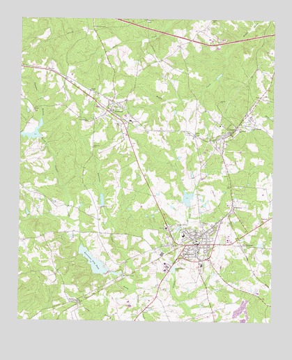
Warrenton, GA USGS Topographic Map
Click on map above to begin viewing in our Map Viewer.

This topographic map contains these locations and features:
Feature Name Type Latitude Longitude GNIS ID View Map
Aggregates LakeReservoirN33.4766°W82.6519°339073View Map
Aggregates Lake DamDamN33.4785°W82.6515°339072View Map
Ambassador ChurchChurchN33.4393°W82.6482°347659View Map
Barksdale CemeteryCemeteryN33.4776°W82.7254°347666View Map
Bethel CemeteryCemeteryN33.4990°W82.6876°347670View Map
Bethel ChurchChurchN33.4999°W82.6879°354612View Map
Briscoe CemeteryCemeteryN33.4358°W82.6470°347672View Map
CamakPopulated PlaceN33.4535°W82.6460°331311View Map
Camak CemeteryCemeteryN33.4549°W82.6424°347674View Map
Camak ChurchChurchN33.4537°W82.6690°347675View Map
Camak JunctionLocaleN33.4207°W82.6462°347676View Map
Camak Methodist ChurchChurchN33.4549°W82.6429°347677View Map
City of NorwoodCivilN33.4625°W82.7055°2404404View Map
City of WarrentonCivilN33.4067°W82.6653°2405675View Map
Community Baptist ChurchChurchN33.4543°W82.6415°347682View Map
Dooley CemeteryCemeteryN33.3790°W82.7212°347685View Map
East WarrentonPopulated PlaceN33.4068°W82.6399°331627View Map
English CemeteryCemeteryN33.3801°W82.6271°347692View Map
English LakeReservoirN33.4101°W82.7232°339075View Map
English Lake DamDamN33.4101°W82.7232°339074View Map
Gospel Aid Society CemeteryCemeteryN33.4693°W82.7124°347700View Map
Hall CemeteryCemeteryN33.4868°W82.6887°347702View Map
Hardaway - Fuller CemeteryCemeteryN33.4549°W82.6276°347705View Map
Heath CemeteryCemeteryN33.4486°W82.6944°347708View Map
Howell CemeteryCemeteryN33.4999°W82.6557°315763View Map
Jane Ball CemeteryCemeteryN33.3926°W82.7110°347716View Map
Johnson DamDamN33.4151°W82.6315°338780View Map
Johnsons LakeReservoirN33.4170°W82.6317°338781View Map
Jones CemeteryCemeteryN33.4705°W82.7144°347719View Map
Kitchens LakeReservoirN33.4072°W82.6308°339077View Map
Kitchens Lake DamDamN33.4068°W82.6299°339076View Map
Lazenby CemeteryCemeteryN33.4669°W82.6508°316709View Map
Lithonia CemeteryCemeteryN33.4517°W82.6630°347724View Map
Lithonia ChurchChurchN33.4524°W82.6640°316925View Map
Mayes CemeteryCemeteryN33.4537°W82.6441°347729View Map
McDaniel CemeteryCemeteryN33.4474°W82.7137°317889View Map
Mildred E Freeman Elementary SchoolSchoolN33.4105°W82.6684°347734View Map
Mount Moriah CemeteryCemeteryN33.3835°W82.7207°347737View Map
Mount Moriah ChurchChurchN33.3832°W82.7204°318700View Map
Nelson DamDamN33.4185°W82.7449°338778View Map
Nelson LakeReservoirN33.4197°W82.7458°338779View Map
NorrisPopulated PlaceN33.3826°W82.7240°332510View Map
NorwoodPopulated PlaceN33.4626°W82.7051°319712View Map
Norwood Baptist ChurchChurchN33.4665°W82.7049°347742View Map
Norwood CemeteryCemeteryN33.4650°W82.7025°347743View Map
Norwood SchoolSchoolN33.4579°W82.6957°319713View Map
Norwood United Methodist ChurchChurchN33.4662°W82.7062°347744View Map
Parham CemeteryCemeteryN33.4007°W82.6710°347745View Map
PlainviewPopulated PlaceN33.4179°W82.6265°332705View Map
Prospect BranchStreamN33.4585°W82.7390°321154View Map
Prospect CemeteryCemeteryN33.4617°W82.7433°347748View Map
Prospect ChurchChurchN33.4621°W82.7432°321167View Map
Reservoir 14ReservoirN33.4248°W82.7089°336397View Map
Ricketson CemeteryCemeteryN33.4403°W82.6459°347754View Map
Rocky Comfort Creek Structure Number 14 DamDamN33.4218°W82.7082°336396View Map
Rocky Comfort Creek Watershed Number 45 DamDamN33.3901°W82.7032°336398View Map
Saint Johns ChurchChurchN33.4637°W82.7004°322129View Map
Sallie Hill CemeteryCemeteryN33.4151°W82.6599°322374View Map
Scott and Labor Home Society CemeteryCemeteryN33.4130°W82.6691°347758View Map
Scruggs CemeteryCemeteryN33.4565°W82.7004°322668View Map
SilvertownPopulated PlaceN33.4224°W82.6446°333057View Map
South Sewage Disposal PondReservoirN33.3967°W82.6734°339506View Map
South Sewage Disposal Pond DamDamN33.3951°W82.6732°339505View Map
Thomas Gibson CemeteryCemeteryN33.4674°W82.6269°347772View Map
Town of CamakCivilN33.4526°W82.6463°2405367View Map
Union Spring ChurchChurchN33.4579°W82.7171°324582View Map
Union Springs CemeteryCemeteryN33.4571°W82.7172°347775View Map
Union Star CemeteryCemeteryN33.3846°W82.7176°347776View Map
Walkers ChapelChurchN33.4707°W82.7154°324789View Map
Warren CountyCivilN33.4090°W82.6768°347777View Map
Warren County CourthouseBuildingN33.4065°W82.6624°347778View Map
Warren County Fire Department Camak StationBuildingN33.4533°W82.6471°2604738View Map
Warren County Fire Department HeadquartersBuildingN33.4100°W82.6529°2603744View Map
Warren County Fire Department Norwood StationBuildingN33.4623°W82.7058°2604752View Map
Warren County High SchoolSchoolN33.4173°W82.6799°347779View Map
Warren County Middle SchoolSchoolN33.4183°W82.6804°324867View Map
Warren County Sheriff's OfficeBuildingN33.4100°W82.6530°2733697View Map
WarrentonPopulated PlaceN33.4071°W82.6621°333368View Map
Warrenton CemeteryCemeteryN33.4099°W82.6640°347780View Map
Warrenton City PondReservoirN33.3992°W82.7127°324866View Map
Warrenton Fire DepartmentBuildingN33.4053°W82.6620°2603774View Map
Warrenton Police DepartmentBuildingN33.4047°W82.6616°2733825View Map
Warrenton Post OfficePost OfficeN33.4065°W82.6640°1705319View Map
Whetstone CreekStreamN33.3885°W82.6921°325126View Map
Williams-Neal CemeteryCemeteryN33.3829°W82.7410°347784View Map
WSAA-FM (Warrenton)TowerN33.4254°W82.6454°352816View Map

Note: Coordinates in the location and feature list above are referenced to NAD83 datum.


Copyright (C) 2008-2024 Ryan Niemi / Sunset Dynamics ... All Rights Reserved