TopoQuest Logo
Do you find TopoQuest useful?
Help keep TopoQuest running and adding new maps/features by donating!
Bitcoin:  19c7KJd3qBynnjoSw5npx9KScwjBe4ifkT
Litecoin:  LXs6TkuXGGXo1vDsWCkWVdjQX94eUKd6ui
Home View Maps Find Maps Find Places Resources & Links


Walnut Grove, Arizona Topographic Map

USGS Map Title: Walnut Grove, AZ
USGS Map MRC: 34112C5
DRG (GeoTIFF) Download: o34112c5.tif


Neighboring USGS Topographic Map Quads:


  Kirkland, AZ  
34112D6
 

  Wilhoit, AZ  
34112D5
 

  Groom Creek, AZ  
34112D4
 

  Peeples Valley, AZ  
34112C6
 

  Walnut Grove, AZ  
34112C5
 

  Battleship Butte, AZ  
34112C4
 

  Yarnell, AZ  
34112B6
 

  Wagoner, AZ  
34112B5
 

  Minnehaha, AZ  
34112B4


Map MRC Location:

N35°
W113°
N35°
W112°
H8 H7 H6 H5 H4 H3 H2 H1
G8 G7 G6 G5 G4 G3 G2 G1
F8 F7 F6 F5 F4 F3 F2 F1
E8 E7 E6 E5 E4 E3 E2 E1
D8 D7 D6 D5 D4 D3 D2 D1
C8 C7 C6 C5 C4 C3 C2 C1
B8 B7 B6 B5 B4 B3 B2 B1
A8 A7 A6 A5 A4 A3 A2 A1
N34°
W113°
N34°
W112°

Walnut Grove, AZ USGS 1:24K Topographic Map Preview:
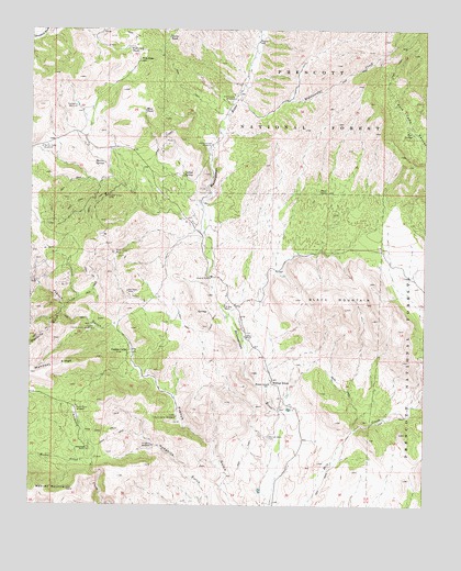
Walnut Grove, AZ USGS Topographic Map
Click on map above to begin viewing in our Map Viewer.

This topographic map contains these locations and features:
Feature Name Type Latitude Longitude GNIS ID View Map
Big Bug Mountains (historical)SummitN34.3334°W112.5007°40505View Map
Big Rebel MineMineN34.3064°W112.5949°26286View Map
Black MountainSummitN34.3020°W112.5254°26423View Map
Boulder WellWellN34.3717°W112.5541°26657View Map
Carter RanchLocaleN34.2945°W112.5574°27313View Map
Carter TankReservoirN34.3730°W112.5823°27314View Map
Collins SpringSpringN34.3367°W112.5773°27819View Map
Copper CampLocaleN34.2906°W112.5946°27902View Map
Copper Crown MineMineN34.3314°W112.6018°27917View Map
Fire Clay HillSummitN34.3667°W112.5896°29002View Map
Fire Clay TankReservoirN34.3702°W112.5949°29003View Map
Hackberry WindmillLocaleN34.3547°W112.6107°29677View Map
Hassayampa WindmillLocaleN34.3445°W112.5685°29785View Map
Hodgkins WindmillLocaleN34.2659°W112.5863°30008View Map
Lower French Gulch WindmillLocaleN34.2734°W112.5788°31355View Map
Mahoney RidgeRidgeN34.2845°W112.6213°31452View Map
Mesa TankReservoirN34.3538°W112.5896°31732View Map
Mescal CreekStreamN34.2597°W112.6055°31746View Map
Middlewater CreekStreamN34.3578°W112.5610°31837View Map
Middlewater WindmillLocaleN34.3567°W112.5607°31838View Map
Miners TankReservoirN34.3470°W112.5478°38633View Map
Moores SpringSpringN34.3401°W112.6024°32013View Map
Placerita GulchValleyN34.3006°W112.6160°33053View Map
Pole SpringSpringN34.3478°W112.5049°33087View Map
River PastureLocaleN34.3461°W112.5691°41071View Map
Rush Place WindmillPopulated PlaceN34.2761°W112.6107°33877View Map
Seep SpringSpringN34.3703°W112.5113°38796View Map
Shaw TankReservoirN34.3325°W112.5320°34313View Map
Silver Crown MineMineN34.3167°W112.5993°34438View Map
T K Bar RanchLocaleN34.3031°W112.5638°35071View Map
Upper French Gulch WindmillLocaleN34.2961°W112.6052°35684View Map
Walker Place WindmillPopulated PlaceN34.3439°W112.6224°35832View Map
Walnut GrovePopulated PlaceN34.2831°W112.5485°35860View Map
Walnut Grove CemeteryCemeteryN34.2681°W112.5498°35861View Map
Walnut Grove SchoolSchoolN34.2820°W112.5496°35862View Map
Whitehead RanchLocaleN34.2647°W112.6068°36121View Map

Note: Coordinates in the location and feature list above are referenced to NAD83 datum.


Copyright (C) 2008-2024 Ryan Niemi / Sunset Dynamics ... All Rights Reserved