TopoQuest Logo
Do you find TopoQuest useful?
Help keep TopoQuest running and adding new maps/features by donating!
Bitcoin:  19c7KJd3qBynnjoSw5npx9KScwjBe4ifkT
Litecoin:  LXs6TkuXGGXo1vDsWCkWVdjQX94eUKd6ui
Home View Maps Find Maps Find Places Resources & Links


Walker Springs, Alabama Topographic Map

USGS Map Title: Walker Springs, AL
USGS Map MRC: 31087E7
DRG (GeoTIFF) Download: o31087e7.tif


Neighboring USGS Topographic Map Quads:


  Winn, AL  
31087F8
 

  Grove Hill, AL  
31087F7
 

  Whatley, AL  
31087F6
 

  Jackson, AL  
31087E8
 

  Walker Springs, AL  
31087E7
 

  Suggsville, AL  
31087E6
 

  Prestwick, AL  
31087D8
 

  Alma, AL  
31087D7
 

  Gainestown, AL  
31087D6


Map MRC Location:

N32°
W88°
N32°
W87°
H8 H7 H6 H5 H4 H3 H2 H1
G8 G7 G6 G5 G4 G3 G2 G1
F8 F7 F6 F5 F4 F3 F2 F1
E8 E7 E6 E5 E4 E3 E2 E1
D8 D7 D6 D5 D4 D3 D2 D1
C8 C7 C6 C5 C4 C3 C2 C1
B8 B7 B6 B5 B4 B3 B2 B1
A8 A7 A6 A5 A4 A3 A2 A1
N31°
W88°
N31°
W87°

Walker Springs, AL USGS 1:24K Topographic Map Preview:
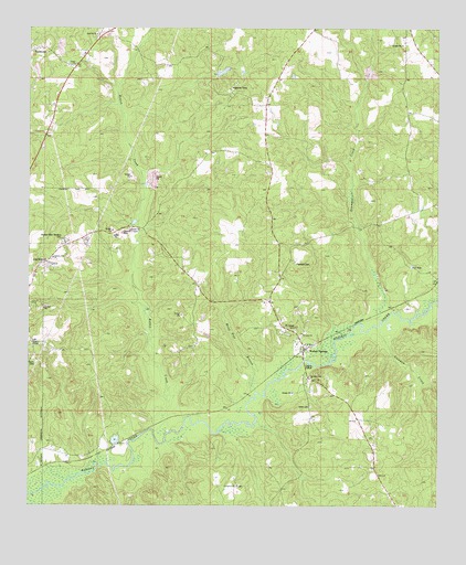
Walker Springs, AL USGS Topographic Map
Click on map above to begin viewing in our Map Viewer.

This topographic map contains these locations and features:
Feature Name Type Latitude Longitude GNIS ID View Map
Antioch Baptist ChurchChurchN31.6235°W87.8547°154967View Map
Antioch CemeteryCemeteryN31.6238°W87.8544°1805656View Map
Antioch Fire DepartmentBuildingN31.6226°W87.8542°2691369View Map
Coleman CreekStreamN31.5471°W87.7697°116413View Map
Evergreen Baptist ChurchChurchN31.5052°W87.8111°118083View Map
Gaddies ChapelChurchN31.5724°W87.8464°118774View Map
Gaddies Chapel CemeteryCemeteryN31.5724°W87.8464°118775View Map
Glendon (historical)LocaleN31.5263°W87.8125°133631View Map
Good Hope Baptist ChurchChurchN31.5416°W87.8247°119113View Map
Greater Pilgrim Rest ChurchChurchN31.5143°W87.7697°163603View Map
Hand Pole BranchStreamN31.5299°W87.8058°119670View Map
Hopewell CemeteryCemeteryN31.5635°W87.7939°120358View Map
Hopewell Methodist ChurchChurchN31.5424°W87.7931°133642View Map
Hotel CemeteryCemeteryN31.5260°W87.7889°164069View Map
Jackson Industrial ParkLocaleN31.5125°W87.8653°2579574View Map
Jackson Memorial Gardens CemeteryCemeteryN31.5690°W87.8642°120777View Map
Kirven (historical)LocaleN31.5571°W87.7522°133660View Map
Lake Daddy Jim SpringLakeN31.5745°W87.8427°133607View Map
Liberty Hill ChurchChurchN31.5649°W87.8678°121572View Map
Maubila Boy Scout LakeReservoirN31.6139°W87.8156°129900View Map
Maubila Boy Scout Lake DamDamN31.6135°W87.8183°129901View Map
Maubila CampLocaleN31.6096°W87.8139°164077View Map
Mount Gilead Baptist ChurchChurchN31.5424°W87.7903°155338View Map
Mount Gilead CemeteryCemeteryN31.5463°W87.7939°123188View Map
Nichola (historical)LocaleN31.5543°W87.7592°133680View Map
Pilgrims Rest ChurchChurchN31.5338°W87.7894°124742View Map
Rabbit CreekStreamN31.5196°W87.8369°125394View Map
Saint Luke ChurchChurchN31.5452°W87.7917°126138View Map
Simmons CreekStreamN31.5479°W87.7728°126871View Map
Thomasville Sanitary LandfillLocaleN31.5909°W87.8200°2579714View Map
Union Methodist ChurchChurchN31.6157°W87.8611°155286View Map
Walker SpringsPopulated PlaceN31.5407°W87.7911°128527View Map
Walker Springs Road Baptist ChurchChurchN31.5652°W87.8674°2580475View Map
WHOD-AM (Jackson)TowerN31.5441°W87.8750°160943View Map
WHOD-FM (Jackson)TowerN31.5441°W87.8750°161140View Map

Note: Coordinates in the location and feature list above are referenced to NAD83 datum.


Copyright (C) 2008-2024 Ryan Niemi / Sunset Dynamics ... All Rights Reserved