TopoQuest Logo
Do you find TopoQuest useful?
Help keep TopoQuest running and adding new maps/features by donating!
Bitcoin:  19c7KJd3qBynnjoSw5npx9KScwjBe4ifkT
Litecoin:  LXs6TkuXGGXo1vDsWCkWVdjQX94eUKd6ui
Home View Maps Find Maps Find Places Resources & Links


Wading River, New York Topographic Map

USGS Map Title: Wading River, NY
USGS Map MRC: 40072H7
DRG (GeoTIFF) Download: o40072h7.tif


Neighboring USGS Topographic Map Quads:


  Middle Island, NY  
40072H8
 

  Wading River, NY  
40072H7
 

  Riverhead, NY  
40072H6
 

  Bellport, NY  
40072G8
 

  Moriches, NY  
40072G7
 

  Eastport, NY  
40072G6


Map MRC Location:

N41°
W73°
N41°
W72°
H8 H7 H6 H5 H4 H3 H2 H1
G8 G7 G6 G5 G4 G3 G2 G1
F8 F7 F6 F5 F4 F3 F2 F1
E8 E7 E6 E5 E4 E3 E2 E1
D8 D7 D6 D5 D4 D3 D2 D1
C8 C7 C6 C5 C4 C3 C2 C1
B8 B7 B6 B5 B4 B3 B2 B1
A8 A7 A6 A5 A4 A3 A2 A1
N40°
W73°
N40°
W72°

Wading River, NY USGS 1:24K Topographic Map Preview:
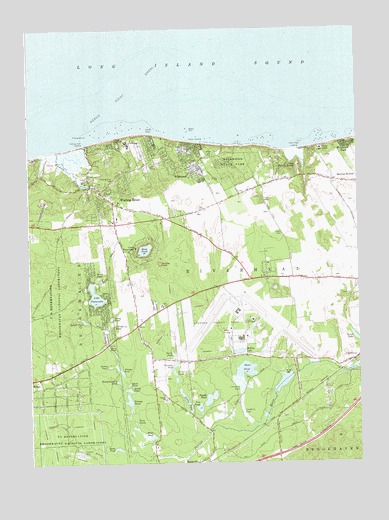
Wading River, NY USGS Topographic Map
Click on map above to begin viewing in our Map Viewer.

This topographic map contains these locations and features:
Feature Name Type Latitude Longitude GNIS ID View Map
Albany RockBarN40.9715°W72.8145°942239View Map
Babylon Rod and Gun Club Wildlife PreserveParkN40.9011°W72.7778°2076286View Map
Baiting Hollow Farm VineyardLocaleN40.9572°W72.7578°2516331View Map
Brookhaven National LaboratoryLocaleN40.8834°W72.8701°975740View Map
Brookhaven State ParkParkN40.9219°W72.8661°2076291View Map
Calverton Census Designated PlaceCensusN40.9163°W72.7644°2389270View Map
Calverton Executive AirparkAirportN40.9204°W72.7939°973512View Map
Calverton LinksLocaleN40.9140°W72.7514°2715377View Map
Calverton National CemeteryCemeteryN40.9319°W72.8152°2076075View Map
Camp Baiting HollowLocaleN40.9604°W72.7723°969950View Map
Camp DeWolfLocaleN40.9670°W72.8409°945568View Map
Camp GrantLocaleN40.9651°W72.7637°945587View Map
Camp Newcombe (historical)LocaleN40.9244°W72.8472°2358809View Map
Camp WauwepexLocaleN40.9373°W72.8348°945681View Map
Conoe LakeLakeN40.9112°W72.7516°947313View Map
Corey PondLakeN40.9168°W72.8439°947444View Map
Cranberry PondLakeN40.9143°W72.8432°947668View Map
Davis Peach FarmLocaleN40.9531°W72.8064°2516329View Map
Deep PondLakeN40.9363°W72.8311°948180View Map
Duck PondLakeN40.8979°W72.8374°948746View Map
Fishing RockBarN40.9695°W72.8532°950174View Map
Forest PondLakeN40.9011°W72.8203°950422View Map
Fox PondLakeN40.8907°W72.8109°950580View Map
Fresh Pond LandingLocaleN40.9651°W72.7720°972514View Map
Grassy PondLakeN40.8932°W72.8377°951570View Map
Great Rock Golf ClubLocaleN40.9544°W72.8251°2715383View Map
Herod PointCapeN40.9701°W72.8301°974219View Map
Herod Point ShoalBarN40.9820°W72.8368°952632View Map
Horn PondLakeN40.9087°W72.8452°953211View Map
Hulse LandingLocaleN40.9673°W72.8112°972636View Map
Jericho LandingLocaleN40.9681°W72.7511°2358850View Map
Jones PondLakeN40.8825°W72.8288°954190View Map
Lake PanamokaLakeN40.9233°W72.8499°959809View Map
Linus PondLakeN40.8923°W72.8154°955425View Map
McKay LakeLakeN40.9071°W72.7953°956788View Map
Nike Site NY-25C (historical)MilitaryN40.9503°W72.8686°2091897View Map
Nike Site NY-25L (historical)MilitaryN40.9406°W72.8722°2091898View Map
North PondLakeN40.9064°W72.8206°958881View Map
North PondLakeN40.9286°W72.8487°958882View Map
North Shore Public LibraryBuildingN40.9414°W72.8672°2715317View Map
Olivers Hill CemeteryCemeteryN40.9567°W72.8516°959348View Map
Pauquaconsuk (historical)AreaN40.9500°W72.8417°2096418View Map
Peasys PondLakeN40.9019°W72.8410°960068View Map
Peconic River County ParkParkN40.8900°W72.8375°2076430View Map
Peconic River Herb FarmLocaleN40.9042°W72.7550°2516327View Map
Prestons PondLakeN40.9031°W72.8199°961128View Map
Ramblewood Mobile Home ParkPopulated PlaceN40.9472°W72.8189°2461076View Map
Ridge Fire Department Station 3BuildingN40.9128°W72.8473°2716049View Map
Round PondLakeN40.9028°W72.8448°962984View Map
Saint Johns ChurchChurchN40.9526°W72.8462°963633View Map
Saint Josephs VillaChurchN40.9629°W72.8729°963793View Map
Sandy PondLakeN40.8930°W72.8076°964438View Map
Sandy PondLakeN40.8962°W72.8374°964439View Map
Scuttle HoleBasinN40.9326°W72.8251°964714View Map
Seven Ponds OrchardLocaleN40.9072°W72.8728°2516136View Map
Swan Lake Golf ClubLocaleN40.9042°W72.7903°2076265View Map
Swan PondLakeN40.9017°W72.7932°966888View Map
Tarkill PondLakeN40.9163°W72.8546°967064View Map
Thurms Mobile HomesPopulated PlaceN40.9486°W72.7864°2461067View Map
Twin PondsLakeN40.8868°W72.8351°968062View Map
Wading RiverPopulated PlaceN40.9504°W72.8426°968624View Map
Wading RiverStreamN40.9651°W72.8682°968625View Map
Wading River CemeteryCemeteryN40.9561°W72.8427°968626View Map
Wading River Census Designated PlaceCensusN40.9465°W72.8230°2390442View Map
Wading River Fire Department Station 2BuildingN40.9590°W72.8082°2735382View Map
Wading River Fire StationBuildingN40.9536°W72.8480°2715874View Map
Wading River LandingLocaleN40.9668°W72.8537°973197View Map
Wading River Post OfficePost OfficeN40.9430°W72.8414°2713600View Map
Wells CemeteryCemeteryN40.9050°W72.7739°969042View Map
West LandingLocaleN40.9647°W72.8689°2358851View Map
WildwoodPopulated PlaceN40.9645°W72.8120°971263View Map
Wildwood State ParkParkN40.9609°W72.7959°971268View Map
Will Miloski's Poultry FarmLocaleN40.9297°W72.7794°2516335View Map
Windy Acre FarmLocaleN40.9297°W72.7506°2516330View Map
Woodchoppers PondLakeN40.8985°W72.8415°971614View Map
Woodcliff ParkPopulated PlaceN40.9668°W72.7540°971624View Map
Zeeks PondLakeN40.8792°W72.8420°971866View Map

Note: Coordinates in the location and feature list above are referenced to NAD83 datum.


Copyright (C) 2008-2024 Ryan Niemi / Sunset Dynamics ... All Rights Reserved