TopoQuest Logo
Do you find TopoQuest useful?
Help keep TopoQuest running and adding new maps/features by donating!
Bitcoin:  19c7KJd3qBynnjoSw5npx9KScwjBe4ifkT
Litecoin:  LXs6TkuXGGXo1vDsWCkWVdjQX94eUKd6ui
Home View Maps Find Maps Find Places Resources & Links


Vinita, Oklahoma Topographic Map

USGS Map Title: Vinita, OK
USGS Map MRC: 36095F2
DRG (GeoTIFF) Download: o36095f2.tif


Neighboring USGS Topographic Map Quads:


  Centralia, OK  
36095G3
 

  Pyramid Corners, OK  
36095G2
 

  Welch South, OK  
36095G1
 

  Estella, OK  
36095F3
 

  Vinita, OK  
36095F2
 

  Vinita NE, OK  
36095F1
 

  White Oak, OK  
36095E3
 

  Big Cabin, OK  
36095E2
 

  Ketchum, OK  
36095E1


Map MRC Location:

N37°
W96°
N37°
W95°
H8 H7 H6 H5 H4 H3 H2 H1
G8 G7 G6 G5 G4 G3 G2 G1
F8 F7 F6 F5 F4 F3 F2 F1
E8 E7 E6 E5 E4 E3 E2 E1
D8 D7 D6 D5 D4 D3 D2 D1
C8 C7 C6 C5 C4 C3 C2 C1
B8 B7 B6 B5 B4 B3 B2 B1
A8 A7 A6 A5 A4 A3 A2 A1
N36°
W96°
N36°
W95°

Vinita, OK USGS 1:24K Topographic Map Preview:
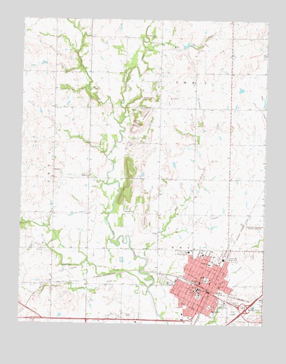
Vinita, OK USGS Topographic Map
Click on map above to begin viewing in our Map Viewer.

This topographic map contains these locations and features:
Feature Name Type Latitude Longitude GNIS ID View Map
Bluejacket CemeteryCemeteryN36.7084°W95.1930°1090301View Map
Bull Creek CenterLocaleN36.6398°W95.1494°1763843View Map
Bull Creek Shopping CenterLocaleN36.6398°W95.1494°1778039View Map
Carters Shopping CenterLocaleN36.6417°W95.1550°1763844View Map
Catholic ChurchChurchN36.6417°W95.1530°1790049View Map
Church of the NazareneChurchN36.6320°W95.1614°1790050View Map
City of VinitaCivilN36.6402°W95.1616°2412159View Map
Craig County JailBuildingN36.6366°W95.1579°2757824View Map
Craig County Sheriff's OfficeBuildingN36.6365°W95.1580°2757441View Map
Donnelly CemeteryCemeteryN36.6715°W95.1963°1092144View Map
Donnelly HillSummitN36.6667°W95.1864°1092145View Map
Dupree ChurchChurchN36.6626°W95.1794°1092306View Map
Elm CreekStreamN36.6515°W95.1847°1092556View Map
Ewing Halsell Middle SchoolSchoolN36.6423°W95.1579°1092679View Map
Fairview CemeteryCemeteryN36.6534°W95.1405°1092718View Map
First Baptist Church SBCChurchN36.6398°W95.1580°1790052View Map
First Baptist Church-SBCChurchN36.6398°W95.1577°1790051View Map
First Christian ChurchChurchN36.6379°W95.1580°1790053View Map
First Church of GodChurchN36.6429°W95.1527°1790055View Map
First United Methodist ChurchChurchN36.6384°W95.1580°1790054View Map
Green Country Christian ChurchChurchN36.6481°W95.1505°1790057View Map
Hall - Halsell Elementary SchoolSchoolN36.6499°W95.1530°1093490View Map
Home of HopeBuildingN36.6565°W95.1605°1093865View Map
Ketchum Police DepartmentBuildingN36.6382°W95.1581°2757605View Map
Keys CemeteryCemeteryN36.7137°W95.1844°1094356View Map
KGND-FM (Ketchum)TowerN36.6884°W95.1919°1102261View Map
KVIN-AM (Vinita)TowerN36.6429°W95.1266°1102223View Map
Mercy Regional Emergency Medical Services - Craig CountyBuildingN36.6424°W95.1519°2695828View Map
Messiah Lutheran ChurchChurchN36.6451°W95.1508°1790058View Map
Mill CreekStreamN36.7390°W95.1869°1095405View Map
North ParkParkN36.6440°W95.1544°1095990View Map
Oklahoma State Highway Patrol - Troop LBuildingN36.6325°W95.1375°2757923View Map
Pawpaw CreekStreamN36.6401°W95.1841°1096483View Map
Pecan CreekStreamN36.6390°W95.1844°1096522View Map
Pentecostal Church of GodChurchN36.6417°W95.1458°1790059View Map
Pentecostal House of Prayer ChurchChurchN36.6390°W95.1561°1790060View Map
Pheasant HillSummitN36.7159°W95.1825°1096592View Map
Pheasant Hill CemeteryCemeteryN36.7179°W95.1895°1096593View Map
Pilgrim Presbyterian ChurchChurchN36.6395°W95.1575°1790061View Map
Riverside SchoolSchoolN36.6406°W95.1483°1097235View Map
Saint Francis Hospital - VinitaHospitalN36.6537°W95.1564°2695758View Map
Saint Johns Episcopal ChurchChurchN36.6392°W95.1611°1790063View Map
Schrimpsher CemeteryCemeteryN36.7427°W95.1835°1097871View Map
Seventh Day Adventist ChurchChurchN36.6490°W95.1500°1790062View Map
Shanahan ChurchChurchN36.6881°W95.2339°1097954View Map
South ParkParkN36.6370°W95.1580°1098269View Map
Southeast SchoolSchoolN36.6306°W95.1508°1098304View Map
Thomas CemeteryCemeteryN36.6533°W95.2128°2710133View Map
Trinity Baptist ChurchChurchN36.6448°W95.1555°1790064View Map
United Pentecostal ChurchChurchN36.6437°W95.1577°1790065View Map
Vineyard Christian Fellowship ChurchChurchN36.6381°W95.1564°1790066View Map
VinitaPopulated PlaceN36.6387°W95.1541°1099271View Map
Vinita Fire DepartmentBuildingN36.6372°W95.1572°2656908View Map
Vinita High SchoolSchoolN36.6551°W95.1639°1819441View Map
Vinita InterchangeCrossingN36.6326°W95.1327°1102098View Map
Vinita Middle SchoolSchoolN36.6395°W95.1600°1819442View Map
Vinita Police DepartmentBuildingN36.6389°W95.1540°2757422View Map
West Fork Big Cabin CreekStreamN36.7073°W95.1997°1099550View Map
Will Rogers Elementary SchoolSchoolN36.6398°W95.1588°1099827View Map

Note: Coordinates in the location and feature list above are referenced to NAD83 datum.


Copyright (C) 2008-2024 Ryan Niemi / Sunset Dynamics ... All Rights Reserved