TopoQuest Logo
Do you find TopoQuest useful?
Help keep TopoQuest running and adding new maps/features by donating!
Bitcoin:  19c7KJd3qBynnjoSw5npx9KScwjBe4ifkT
Litecoin:  LXs6TkuXGGXo1vDsWCkWVdjQX94eUKd6ui
Home View Maps Find Maps Find Places Resources & Links


Vandemere, North Carolina Topographic Map

USGS Map Title: Vandemere, NC
USGS Map MRC: 35076B6
DRG (GeoTIFF) Download: o35076b6.tif


Neighboring USGS Topographic Map Quads:


  Aurora, NC  
35076C7
 

  South Creek, NC  
35076C6
 

  Lowland, NC  
35076C5
 

  Bayboro, NC  
35076B7
 

  Vandemere, NC  
35076B6
 

  Jones Bay, NC  
35076B5
 

  Arapahoe, NC  
35076A7
 

  Oriental, NC  
35076A6
 

  Broad Creek, NC  
35076A5


Map MRC Location:

N36°
W77°
N36°
W76°
H8 H7 H6 H5 H4 H3 H2 H1
G8 G7 G6 G5 G4 G3 G2 G1
F8 F7 F6 F5 F4 F3 F2 F1
E8 E7 E6 E5 E4 E3 E2 E1
D8 D7 D6 D5 D4 D3 D2 D1
C8 C7 C6 C5 C4 C3 C2 C1
B8 B7 B6 B5 B4 B3 B2 B1
A8 A7 A6 A5 A4 A3 A2 A1
N35°
W77°
N35°
W76°

Vandemere, NC USGS 1:24K Topographic Map Preview:
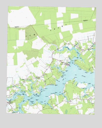
Vandemere, NC USGS Topographic Map
Click on map above to begin viewing in our Map Viewer.

This topographic map contains these locations and features:
Feature Name Type Latitude Longitude GNIS ID View Map
Alligator CreekStreamN35.1277°W76.7299°980134View Map
Alligator PointCapeN35.1918°W76.6513°980140View Map
Antioch ChurchChurchN35.1713°W76.6977°980221View Map
Armstrong CreekStreamN35.1491°W76.7330°1008769View Map
Ball CreekStreamN35.1593°W76.6324°980492View Map
Bay Creek ChurchChurchN35.2010°W76.6349°980652View Map
Bee Tree CreekStreamN35.1499°W76.7144°980895View Map
Bell PointCapeN35.1677°W76.6538°980942View Map
Box PointCapeN35.1782°W76.6444°981782View Map
Cabin CreekBayN35.1568°W76.6266°1024753View Map
Cedar CreekStreamN35.1874°W76.6588°982809View Map
Cedar PointCapeN35.1610°W76.6335°982892View Map
Cedar PointCapeN35.1879°W76.6580°982893View Map
Chapel CreekStreamN35.1449°W76.7091°983006View Map
Chapel Creek PointCapeN35.1463°W76.7049°983008View Map
Chappel CreekStreamN35.1493°W76.6683°983030View Map
Concord ChurchChurchN35.1407°W76.6594°983429View Map
Darby PointCapeN35.1849°W76.6555°983952View Map
Flea PointCapeN35.1454°W76.6899°985204View Map
FlorencePopulated PlaceN35.1443°W76.6310°1020293View Map
Florence - Whortonsville Volunteer Fire DepartmentBuildingN35.1435°W76.6517°2638268View Map
Fowler PointCapeN35.1404°W76.7191°985349View Map
Graveyard PointCapeN35.1885°W76.6533°985980View Map
Gum SwampSwampN35.2299°W76.7033°1024760View Map
Hall PointCapeN35.1438°W76.7138°986318View Map
Harper CreekBayN35.1546°W76.6972°986428View Map
Harper PointCapeN35.1596°W76.6799°986430View Map
Harris CreekStreamN35.1763°W76.6252°986444View Map
HollyvillePopulated PlaceN35.1913°W76.6852°1024754View Map
Lambert PointCapeN35.1552°W76.6955°988113View Map
Lewis CreekStreamN35.1363°W76.6935°988394View Map
Little Pasture CreekStreamN35.1643°W76.6524°988724View Map
Little Vandemere CreekStreamN35.2029°W76.6535°988796View Map
Log Pond CreekStreamN35.1857°W76.6605°988860View Map
Long CreekStreamN35.1904°W76.6472°988949View Map
Lynch BeachPopulated PlaceN35.1602°W76.6863°1021315View Map
MaribelPopulated PlaceN35.1668°W76.7066°989335View Map
Maribel SchoolSchoolN35.1716°W76.6960°989336View Map
Mason BayBayN35.1391°W76.6960°989432View Map
Mason CreekStreamN35.1374°W76.6919°989433View Map
Mason PointCapeN35.1413°W76.7077°989435View Map
MesicPopulated PlaceN35.2004°W76.6438°1021416View Map
Mesic CreekStreamN35.1752°W76.6319°1024762View Map
Moore BayBayN35.1499°W76.6766°990171View Map
Moore CreekStreamN35.1488°W76.6719°990175View Map
Mount Olive ChurchChurchN35.2021°W76.6472°990469View Map
Mount Sinai ChurchChurchN35.1371°W76.7455°990571View Map
Mount Zion ChurchChurchN35.1771°W76.6872°990637View Map
Newton CreekBayN35.1638°W76.6783°1024765View Map
Pamlico CountyCivilN35.1510°W76.6695°1023355View Map
Parch Corn BayBayN35.1691°W76.6710°991846View Map
Pasture CreekStreamN35.1560°W76.6372°991913View Map
Petty PointCapeN35.1746°W76.6352°992108View Map
Poorhouse PointCapeN35.1707°W76.6713°992670View Map
Powers PointCapeN35.1491°W76.6830°992778View Map
Punch BowlBayN35.1482°W76.7060°992903View Map
Raccoon CreekStreamN35.1504°W76.7308°992965View Map
Raccoon Creek PointCapeN35.1504°W76.7291°992966View Map
Raccoon IslandIslandN35.1479°W76.7269°992968View Map
Rice CreekStreamN35.1624°W76.6488°993280View Map
Saint Galilee ChurchChurchN35.1679°W76.7010°993895View Map
Saint James ChurchChurchN35.1852°W76.6697°993904View Map
Saint Mark ChurchChurchN35.1382°W76.6288°994007View Map
Saint Peters ChurchChurchN35.1877°W76.6744°994113View Map
Simpson CreekStreamN35.1485°W76.6377°994851View Map
Smith CreekStreamN35.1741°W76.6705°994963View Map
Smith Creek PointCapeN35.1732°W76.6713°994972View Map
StonewallPopulated PlaceN35.1374°W76.7477°1022801View Map
Stonewall Post OfficePost OfficeN35.1373°W76.7473°2774361View Map
Swan CornerPopulated PlaceN35.1652°W76.7224°1024800View Map
Swan CoveBayN35.1504°W76.7008°995741View Map
Swan PointCapeN35.1477°W76.7027°995751View Map
Swindell BayBayN35.1396°W76.7124°995791View Map
Tempe GutStreamN35.1574°W76.6935°995914View Map
The HammockIslandN35.1510°W76.7027°995979View Map
Town of MesicCivilN35.2034°W76.6449°2406150View Map
Town of StonewallCivilN35.1371°W76.7406°2406672View Map
Town of VandemereCivilN35.1886°W76.6651°2406790View Map
Trent CreekStreamN35.1432°W76.7208°996218View Map
Turtle GutGutN35.1313°W76.7338°996370View Map
VandemerePopulated PlaceN35.1841°W76.6635°1023072View Map
Vandemere CreekStreamN35.1835°W76.6591°996586View Map
Vandemere Fire DepartmentBuildingN35.1848°W76.6685°2638180View Map
White Pine ShoalBarN35.1827°W76.6513°997193View Map
Whitehurst CreekStreamN35.1613°W76.7133°997229View Map
Windmill PointCapeN35.1754°W76.6666°997473View Map
Wise PointCapeN35.1738°W76.6291°997510View Map

Note: Coordinates in the location and feature list above are referenced to NAD83 datum.


Copyright (C) 2008-2024 Ryan Niemi / Sunset Dynamics ... All Rights Reserved