TopoQuest Logo
Do you find TopoQuest useful?
Help keep TopoQuest running and adding new maps/features by donating!
Bitcoin:  19c7KJd3qBynnjoSw5npx9KScwjBe4ifkT
Litecoin:  LXs6TkuXGGXo1vDsWCkWVdjQX94eUKd6ui
Home View Maps Find Maps Find Places Resources & Links


Van Wyck, South Carolina Topographic Map

USGS Map Title: Van Wyck, SC
USGS Map MRC: 34080G7
DRG (GeoTIFF) Download: o34080g7.tif


Neighboring USGS Topographic Map Quads:


  Rock Hill East, SC  
34080H8
 

  Catawba NE, SC  
34080H7
 

  Waxhaw, NC  
34080H6
 

  Catawba, SC  
34080G8
 

  Van Wyck, SC  
34080G7
 

  Unity, SC  
34080G6
 

  Fort Lawn, SC  
34080F8
 

  Lancaster, SC  
34080F7
 

  Antioch, SC  
34080F6


Map MRC Location:

N35°
W81°
N35°
W80°
H8 H7 H6 H5 H4 H3 H2 H1
G8 G7 G6 G5 G4 G3 G2 G1
F8 F7 F6 F5 F4 F3 F2 F1
E8 E7 E6 E5 E4 E3 E2 E1
D8 D7 D6 D5 D4 D3 D2 D1
C8 C7 C6 C5 C4 C3 C2 C1
B8 B7 B6 B5 B4 B3 B2 B1
A8 A7 A6 A5 A4 A3 A2 A1
N34°
W81°
N34°
W80°

Van Wyck, SC USGS 1:24K Topographic Map Preview:
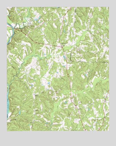
Van Wyck, SC USGS Topographic Map
Click on map above to begin viewing in our Map Viewer.

This topographic map contains these locations and features:
Feature Name Type Latitude Longitude GNIS ID View Map
Andrew Jackson MemorialCemeteryN34.8657°W80.7876°980185View Map
Andrew Jackson State ParkParkN34.8396°W80.8051°1220204View Map
Andrew Jackson State Park LakeReservoirN34.8451°W80.8081°1237699View Map
Arrowood EstatesPopulated PlaceN34.7599°W80.7928°1241591View Map
Ashes Ferry (historical)CrossingN34.8538°W80.8676°1233589View Map
Causar BranchStreamN34.8268°W80.8217°1221416View Map
Cedar Grove School (historical)SchoolN34.8096°W80.8209°1241616View Map
Charlotte Road - Van Wyck Station 5BuildingN34.8399°W80.8282°2578227View Map
Craigsville School (historical)SchoolN34.7751°W80.7909°1241626View Map
Culp LakeReservoirN34.8246°W80.8043°1237696View Map
Culp Lake D-1757 DamDamN34.8263°W80.8051°1237695View Map
Cureton CemeteryCemeteryN34.8143°W80.7940°1221878View Map
Curetons (historical)Populated PlaceN34.8682°W80.7917°1241627View Map
David Stand ChurchChurchN34.7590°W80.8434°1247494View Map
Davis BranchStreamN34.8549°W80.7662°983985View Map
Doods Pond Dam D-1755DamN34.7985°W80.8231°1239187View Map
Ebenezer ChurchChurchN34.8363°W80.8062°1222221View Map
Ferry BranchStreamN34.8435°W80.8715°1222379View Map
Flag Pond BranchStreamN34.7921°W80.7756°985146View Map
Foster BranchStreamN34.8026°W80.8615°1222506View Map
Foster Industrial ParkLocaleN34.7860°W80.8512°1241654View Map
Fosters CrossroadsPopulated PlaceN34.7865°W80.8412°1247812View Map
Hawks Meadow AirportAirportN34.8332°W80.7512°2679277View Map
Helms Pond Dam D-1758DamN34.7785°W80.8031°1239196View Map
Izards Mill (historical)LocaleN34.7843°W80.8737°1241679View Map
Jackson Grove ChurchChurchN34.8599°W80.7920°987494View Map
Keener BranchStreamN34.8538°W80.7553°979992View Map
Lancaster SpeedwayLocaleN34.7790°W80.7870°1242432View Map
McAteer BranchStreamN34.7913°W80.8017°1224380View Map
Mill BranchStreamN34.8035°W80.8662°1224514View Map
Mount Tabor ChurchChurchN34.7774°W80.7720°1249687View Map
Mount Tabor School (historical)SchoolN34.7774°W80.7715°1241717View Map
Mount Zion Baptist Church CemeteryCemeteryN34.8674°W80.7896°2778870View Map
Mount Zion ChurchChurchN34.8676°W80.7898°990630View Map
Nesbits PondReservoirN34.8622°W80.8385°1237698View Map
Nisbet Pond Dam Number One D-1754DamN34.8635°W80.8365°1239191View Map
Nisbet Pond Dam Number Two D-1753DamN34.8618°W80.8381°1237697View Map
North Corner ChurchChurchN34.8204°W80.7973°991208View Map
North Corner ChurchChurchN34.8204°W80.7973°1249887View Map
North Lancaster School (historical)SchoolN34.7571°W80.7676°1241722View Map
Old Waxhaw ChurchChurchN34.7888°W80.8328°1249978View Map
Quail HavenPopulated PlaceN34.7590°W80.8090°1241743View Map
RiversidePopulated PlaceN34.7713°W80.8409°1250393View Map
Riverside Fire Department Station 16BuildingN34.7555°W80.8449°2578218View Map
Robinwood EstatesPopulated PlaceN34.7621°W80.7517°1241749View Map
Saint Johns ChurchChurchN34.7657°W80.7973°1250559View Map
Sandy BranchStreamN34.7710°W80.8173°1226359View Map
Sherrells PondReservoirN34.8068°W80.7981°1237701View Map
Sherrill Pond Dam D-1778DamN34.8068°W80.7981°1237700View Map
ShilohPopulated PlaceN34.7749°W80.7903°1250860View Map
Shiloh Associate Reformed Presbyterian ChurchChurchN34.7740°W80.7817°1241760View Map
Shiloh CemeteryCemeteryN34.7732°W80.7812°1241761View Map
Shiloh Zion Fire Department Station 17BuildingN34.7546°W80.7597°2578812View Map
Shiloh Zion Fire Department SubstationBuildingN34.7811°W80.7552°2578413View Map
Spring Dale School (historical)SchoolN34.8299°W80.8720°1241766View Map
Stinson CemeteryCemeteryN34.8340°W80.8262°1241773View Map
Taylors Grove ChurchChurchN34.7724°W80.7876°1251130View Map
Todd BranchStreamN34.8654°W80.8473°1227163View Map
Town of Van WyckCivilN34.8504°W80.8369°2791461View Map
Twelvemile CreekStreamN34.8535°W80.8665°996381View Map
Van WyckPopulated PlaceN34.8585°W80.8459°1251287View Map
Van Wyck Ferry (historical)CrossingN34.8538°W80.8676°1241794View Map
WAGL-AM (Lancaster)TowerN34.8315°W80.8687°1252380View Map
Waxhaw CemeteryCemeteryN34.7901°W80.8317°1241796View Map
Waxhaw CreekStreamN34.7971°W80.8740°996883View Map
White Oak ChurchChurchN34.8493°W80.8473°1251412View Map
White Oak School (historical)SchoolN34.8496°W80.8473°1241803View Map
Wrenn Farm Pond Dam D-1756DamN34.7685°W80.8598°1239186View Map
Wrens CemeteryCemeteryN34.8449°W80.8170°1241806View Map
WRHM-FM (Lancaster)TowerN34.8015°W80.7973°1252515View Map

Note: Coordinates in the location and feature list above are referenced to NAD83 datum.


Copyright (C) 2008-2024 Ryan Niemi / Sunset Dynamics ... All Rights Reserved