TopoQuest Logo
Do you find TopoQuest useful?
Help keep TopoQuest running and adding new maps/features by donating!
Bitcoin:  19c7KJd3qBynnjoSw5npx9KScwjBe4ifkT
Litecoin:  LXs6TkuXGGXo1vDsWCkWVdjQX94eUKd6ui
Home View Maps Find Maps Find Places Resources & Links


Valdese, North Carolina Topographic Map

USGS Map Title: Valdese, NC
USGS Map MRC: 35081F5
DRG (GeoTIFF) Download: o35081f5.tif


Neighboring USGS Topographic Map Quads:


  Morganton North, NC  
35081G6
 

  Drexel, NC  
35081G5
 

  Granite Falls, NC  
35081G4
 

  Morganton South, NC  
35081F6
 

  Valdese, NC  
35081F5
 

  Longview, NC  
35081F4
 

  Benn Knob, NC  
35081E6
 

  Casar, NC  
35081E5
 

  Banoak, NC  
35081E4


Map MRC Location:

N36°
W82°
N36°
W81°
H8 H7 H6 H5 H4 H3 H2 H1
G8 G7 G6 G5 G4 G3 G2 G1
F8 F7 F6 F5 F4 F3 F2 F1
E8 E7 E6 E5 E4 E3 E2 E1
D8 D7 D6 D5 D4 D3 D2 D1
C8 C7 C6 C5 C4 C3 C2 C1
B8 B7 B6 B5 B4 B3 B2 B1
A8 A7 A6 A5 A4 A3 A2 A1
N35°
W82°
N35°
W81°

Valdese, NC USGS 1:24K Topographic Map Preview:
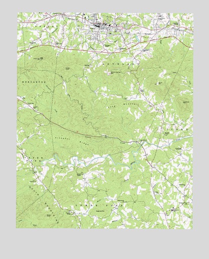
Valdese, NC USGS Topographic Map
Click on map above to begin viewing in our Map Viewer.

This topographic map contains these locations and features:
Feature Name Type Latitude Longitude GNIS ID View Map
AbeeLocaleN35.7037°W81.5373°1001448View Map
Abees ChapelChurchN35.7054°W81.5373°1000723View Map
Abees Grove ChurchChurchN35.7293°W81.5512°980018View Map
Ball Alley CreekStreamN35.6787°W81.5629°980491View Map
Bethlehem ChurchChurchN35.7496°W81.5926°1000732View Map
Bollingers ChapelChurchN35.7315°W81.5615°981699View Map
Burke County Emergency Services Station 2BuildingN35.7497°W81.5241°2720429View Map
Butler KnobSummitN35.6329°W81.6031°1019440View Map
Carswell ChurchChurchN35.6526°W81.6104°1000735View Map
Connelly SpringsPopulated PlaceN35.7429°W81.5134°1019758View Map
Connelly Springs Post OfficePost OfficeN35.7409°W81.5028°2774057View Map
Connely Springs 1stChurchN35.7426°W81.5076°1007735View Map
Cross Roads of Life ChurchChurchN35.6712°W81.5073°983784View Map
Cub CreekStreamN35.6779°W81.5076°983819View Map
Double BranchStreamN35.7493°W81.5820°984279View Map
Flat GapPopulated PlaceN35.7204°W81.5712°1020270View Map
Garrison CreekStreamN35.6876°W81.6012°985590View Map
George Hildebran Fire and Rescue DepartmentBuildingN35.6503°W81.5041°2639163View Map
George Hildebrand Elementary SchoolSchoolN35.6376°W81.5131°1001466View Map
High PeakSummitN35.7235°W81.6084°986752View Map
High Peak ChurchChurchN35.7326°W81.5965°986753View Map
Hildebran MountainSummitN35.6974°W81.5068°1000754View Map
Hildebran SchoolSchoolN35.6362°W81.5134°986788View Map
Hildebran View ChurchChurchN35.6401°W81.5031°986789View Map
Icard Grove ChurchChurchN35.7285°W81.5345°987315View Map
Laurel CreekStreamN35.6732°W81.5359°988188View Map
Laurel SchoolSchoolN35.6951°W81.6123°988208View Map
Laurel Seventh Day Adventist ChurchChurchN35.6893°W81.6031°1007730View Map
Long MountainRidgeN35.6968°W81.5512°988976View Map
Lovelady Volunteer Fire DepartmentBuildingN35.7497°W81.5245°2639094View Map
McCorkle DamDamN35.6885°W81.5248°999251View Map
McCorkle LakeReservoirN35.6882°W81.5245°999252View Map
Mineral Springs MountainSummitN35.7157°W81.5581°990051View Map
Montague HillsRidgeN35.7096°W81.5143°1001706View Map
Mount Calvary ChurchChurchN35.6696°W81.5090°1007728View Map
NonameReservoirN35.7368°W81.5398°999326View Map
Peasant Grove Baptist ChurchChurchN35.6343°W81.5873°1007729View Map
Petche GapPopulated PlaceN35.6965°W81.6162°992079View Map
Philadelphia ChurchChurchN35.6499°W81.5054°992126View Map
Pleasant GrovePopulated PlaceN35.6337°W81.5837°992456View Map
Prospect RidgeRidgeN35.6765°W81.5823°992855View Map
Queens CreekStreamN35.6651°W81.5023°992949View Map
Rector KnobSummitN35.7179°W81.5898°993097View Map
Rock CreekStreamN35.6632°W81.5412°993492View Map
Rutherford CollegePopulated PlaceN35.7485°W81.5226°1024878View Map
Rutherford College (historical)SchoolN35.7485°W81.5226°1024875View Map
Rutherford College Elementary SchoolSchoolN35.7485°W81.5234°1001487View Map
Rutherford College Post OfficePost OfficeN35.7478°W81.5250°2774081View Map
Saint John ChurchChurchN35.6457°W81.5240°993923View Map
Shady Grove ChurchChurchN35.6401°W81.5479°994548View Map
Smart Grove ChurchChurchN35.6749°W81.5365°1000785View Map
Smith BranchStreamN35.7468°W81.5156°994933View Map
Smith MountainSummitN35.7099°W81.5248°994989View Map
Sugarloaf MountainSummitN35.6346°W81.5684°1022830View Map
Town of ValdeseCivilN35.7441°W81.5484°2406784View Map
Township of LoveladyCivilN35.7414°W81.5407°1026461View Map
Trinity ChurchChurchN35.7324°W81.6143°996247View Map
Triple Community Fire DepartmentBuildingN35.7451°W81.6167°2639152View Map
United Baptist ChurchChurchN35.7407°W81.5915°1007733View Map
ValdesePopulated PlaceN35.7407°W81.5631°996570View Map
Valdese Elementary SchoolSchoolN35.7460°W81.5684°1001491View Map
Valdese Fire DepartmentBuildingN35.7436°W81.5640°2638098View Map
Valdese General HospitalHospitalN35.7481°W81.5233°1001492View Map
Valdese Junior High SchoolSchoolN35.7449°W81.5668°1001493View Map
Valdese Lake DamDamN35.7368°W81.5398°999327View Map
Valdese Police DepartmentBuildingN35.7429°W81.5640°2769589View Map
Valdese Post OfficePost OfficeN35.7421°W81.5634°2773823View Map
Walker ChapelChurchN35.6571°W81.5784°1000796View Map
Warlicks ChapelChurchN35.6801°W81.5195°996794View Map
WSVM-AM (Valdese)TowerN35.7343°W81.5676°1018489View Map

Note: Coordinates in the location and feature list above are referenced to NAD83 datum.


Copyright (C) 2008-2024 Ryan Niemi / Sunset Dynamics ... All Rights Reserved