TopoQuest Logo
Do you find TopoQuest useful?
Help keep TopoQuest running and adding new maps/features by donating!
Bitcoin:  19c7KJd3qBynnjoSw5npx9KScwjBe4ifkT
Litecoin:  LXs6TkuXGGXo1vDsWCkWVdjQX94eUKd6ui
Home View Maps Find Maps Find Places Resources & Links


Uvalde, Texas Topographic Map

USGS Map Title: Uvalde, TX
USGS Map MRC: 29099B7
DRG (GeoTIFF) Download: o29099b7.tif


Neighboring USGS Topographic Map Quads:


  Chalk Bluff, TX  
29099C8
 

  Sevenmile Hill, TX  
29099C7
 

  Knippa, TX  
29099C6
 

  Hacienda, TX  
29099B8
 

  Uvalde, TX  
29099B7
 

  Garner Field, TX  
29099B6
 

  Sand Mountain, TX  
29099A8
 

  Pulliam Ranch, TX  
29099A7
 

  Batesville Hill, TX  
29099A6


Map MRC Location:

N30°
W100°
N30°
W99°
H8 H7 H6 H5 H4 H3 H2 H1
G8 G7 G6 G5 G4 G3 G2 G1
F8 F7 F6 F5 F4 F3 F2 F1
E8 E7 E6 E5 E4 E3 E2 E1
D8 D7 D6 D5 D4 D3 D2 D1
C8 C7 C6 C5 C4 C3 C2 C1
B8 B7 B6 B5 B4 B3 B2 B1
A8 A7 A6 A5 A4 A3 A2 A1
N29°
W100°
N29°
W99°

Uvalde, TX USGS 1:24K Topographic Map Preview:
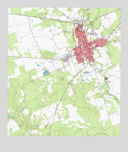
Uvalde, TX USGS Topographic Map
Click on map above to begin viewing in our Map Viewer.

This topographic map contains these locations and features:
Feature Name Type Latitude Longitude GNIS ID View Map
American Legion ParkParkN29.2180°W99.7587°2028890View Map
Anthon Elementary SchoolSchoolN29.2252°W99.7956°2009041View Map
Anthon SchoolSchoolN29.2041°W99.8059°1351183View Map
Apostolic ChurchChurchN29.2033°W99.7937°2024344View Map
Ball QuarryMineN29.1769°W99.8383°2710180View Map
Benson AirstripAirportN29.2237°W99.8249°2675806View Map
Benson Elementary SchoolSchoolN29.2169°W99.7928°2009044View Map
Benson SchoolSchoolN29.2166°W99.7928°1351896View Map
Boon SloughStreamN29.2308°W99.8098°1372676View Map
Brice Lane ColoniaPopulated PlaceN29.2022°W99.7814°2010761View Map
City of UvaldeCivilN29.2154°W99.7782°2412138View Map
Cooks SloughStreamN29.1730°W99.7634°1354910View Map
Dalton Elementary SchoolSchoolN29.2222°W99.7778°2009045View Map
Dalton SchoolSchoolN29.2205°W99.7759°1355559View Map
DeLeon ParkLocaleN29.2019°W99.7903°1355745View Map
DeLeon ParkParkN29.2033°W99.8001°2028488View Map
Excel AcademySchoolN29.2064°W99.7945°2009046View Map
First Baptist ChurchChurchN29.2105°W99.7889°2024345View Map
First Presbyterian ChurchChurchN29.2127°W99.7873°2024350View Map
Flores Elementary SchoolSchoolN29.2222°W99.7917°2009047View Map
Fort Clark Road ColoniaPopulated PlaceN29.2014°W99.8192°2010762View Map
Fort IngePopulated PlaceN29.1777°W99.7645°1379788View Map
Fort Inge Historical Site County ParkParkN29.1800°W99.7623°2028308View Map
Gabriel Tafolla Charter SchoolSchoolN29.2158°W99.7889°2009048View Map
Garner Road Baptist ChurchChurchN29.2152°W99.7681°2024346View Map
Gonzales ColoniaPopulated PlaceN29.1983°W99.8042°2010763View Map
Grand Opera HouseBuildingN29.2102°W99.7867°2031140View Map
Hillcrest Memorial ParkLocaleN29.2008°W99.8120°1359267View Map
Hoag DamDamN29.1701°W99.7635°1359316View Map
Hoag LakeReservoirN29.1702°W99.7637°1862441View Map
Honey Bowl StadiumParkN29.2291°W99.7953°1384574View Map
Honey Bowl StadiumParkN29.2291°W99.7942°2027846View Map
Inge MountainSummitN29.1814°W99.7656°1360008View Map
John Nance Garner HouseBuildingN29.2125°W99.7926°2030867View Map
John Nance Garner MuseumBuildingN29.2122°W99.7917°2014410View Map
KLXQ-FM (Uvalde)TowerN29.1964°W99.7803°1386035View Map
KVOU-AM (Uvalde)TowerN29.1880°W99.7770°1385714View Map
KYUF-FM (Uvalde)TowerN29.1880°W99.7770°1386034View Map
La Divina Trinidad Methodist ChurchChurchN29.2008°W99.7823°2024349View Map
Leona SpringsSpringN29.2086°W99.7920°1998327View Map
Leona SpringsSpringN29.1919°W99.7753°1998328View Map
McDaniels DamDamN29.1419°W99.8737°1862442View Map
McDaniels TankReservoirN29.1419°W99.8737°1862443View Map
New Light Baptist ChurchChurchN29.2047°W99.7948°2024347View Map
New Testament Fellowship ChurchChurchN29.2022°W99.7898°2024352View Map
North Uvalde ColoniaPopulated PlaceN29.2391°W99.8023°2010764View Map
Pioneer Park CemeteryCemeteryN29.2150°W99.7928°1365337View Map
Robb Elementary SchoolSchoolN29.2005°W99.7881°2009051View Map
Robb SchoolSchoolN29.1994°W99.7881°1366561View Map
Rocky HillSummitN29.1805°W99.8156°1366786View Map
Seventh Day Adventist ChurchChurchN29.2175°W99.7917°2024351View Map
South Grove Street ColoniaPopulated PlaceN29.1952°W99.7864°2010765View Map
Taylor SloughStreamN29.1950°W99.7720°1369659View Map
Trinity Fellowship of Uvalde ChurchChurchN29.2252°W99.7792°2024353View Map
Trinity Lutheran ChurchChurchN29.2205°W99.7906°2024348View Map
Twomile WaterholeLakeN29.2340°W99.7840°1370409View Map
United States Border Patrol StationBuildingN29.2137°W99.7518°2750821View Map
UvaldePopulated PlaceN29.2097°W99.7862°1370541View Map
Uvalde City HallBuildingN29.2094°W99.7856°2753980View Map
Uvalde County Hospital Authority HeliportAirportN29.2141°W99.7681°1387669View Map
Uvalde County JailBuildingN29.2112°W99.7855°2738792View Map
Uvalde County Sheriff's OfficeBuildingN29.2112°W99.7856°2750218View Map
Uvalde Emergency Medical ServiceBuildingN29.2076°W99.7857°2656177View Map
Uvalde EstatesPopulated PlaceN29.1652°W99.8323°1852775View Map
Uvalde Estates Census Designated PlaceCensusN29.1695°W99.8329°2409384View Map
Uvalde Estates ColoniaPopulated PlaceN29.1641°W99.8323°2010766View Map
Uvalde Fire Department Station 1BuildingN29.2082°W99.7858°2551874View Map
Uvalde Fire Department Station 2BuildingN29.2287°W99.7603°2551275View Map
Uvalde Grand Opera HouseBuildingN29.2102°W99.7864°2014412View Map
Uvalde High SchoolSchoolN29.2191°W99.7834°2009056View Map
Uvalde Junior High SchoolSchoolN29.2261°W99.7834°2009057View Map
Uvalde Memorial HospitalHospitalN29.2140°W99.7681°2015691View Map
Uvalde National Fish HatcheryLocaleN29.1864°W99.8326°1384698View Map
Uvalde Police DepartmentBuildingN29.2033°W99.8039°2750641View Map
Uvalde Post OfficePost OfficeN29.2091°W99.7863°2731970View Map
Vanessa Street ColoniaPopulated PlaceN29.1941°W99.7984°2010767View Map
Vanham Addition ColoniaPopulated PlaceN29.2391°W99.7942°2010768View Map
West End ParkLocaleN29.2030°W99.7995°1371116View Map

Note: Coordinates in the location and feature list above are referenced to NAD83 datum.


Copyright (C) 2008-2024 Ryan Niemi / Sunset Dynamics ... All Rights Reserved