TopoQuest Logo
Do you find TopoQuest useful?
Help keep TopoQuest running and adding new maps/features by donating!
Bitcoin:  19c7KJd3qBynnjoSw5npx9KScwjBe4ifkT
Litecoin:  LXs6TkuXGGXo1vDsWCkWVdjQX94eUKd6ui
Home View Maps Find Maps Find Places Resources & Links


Utica West, Mississippi Topographic Map

USGS Map Title: Utica West, MS
USGS Map MRC: 32090A6
DRG (GeoTIFF) Download: o32090a6.tif


Neighboring USGS Topographic Map Quads:


  Big Black, MS  
32090B7
 

  Cayuga, MS  
32090B6
 

  Learned, MS  
32090B5
 

  Carlisle, MS  
32090A7
 

  Utica West, MS  
32090A6
 

  Utica East, MS  
32090A5
 

  Hermanville, MS  
31090H7
 

  Dentville NW, MS  
31090H6
 

  Dentville, MS  
31090H5


Map MRC Location:

N33°
W91°
N33°
W90°
H8 H7 H6 H5 H4 H3 H2 H1
G8 G7 G6 G5 G4 G3 G2 G1
F8 F7 F6 F5 F4 F3 F2 F1
E8 E7 E6 E5 E4 E3 E2 E1
D8 D7 D6 D5 D4 D3 D2 D1
C8 C7 C6 C5 C4 C3 C2 C1
B8 B7 B6 B5 B4 B3 B2 B1
A8 A7 A6 A5 A4 A3 A2 A1
N32°
W91°
N32°
W90°

Utica West, MS USGS 1:24K Topographic Map Preview:
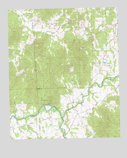
Utica West, MS USGS Topographic Map
Click on map above to begin viewing in our Map Viewer.

This topographic map contains these locations and features:
Feature Name Type Latitude Longitude GNIS ID View Map
Anderson CemeteryCemeteryN32.0576°W90.7265°666254View Map
Breeden CemeteryCemeteryN32.0943°W90.6712°667538View Map
Byrnes School (historical)SchoolN32.0465°W90.7298°686754View Map
CarpenterPopulated PlaceN32.0340°W90.6804°668080View Map
Carpenter CemeteryCemeteryN32.0451°W90.6829°668081View Map
Carroway Pond DamDamN32.0702°W90.6401°680999View Map
Choctaw CreekStreamN32.0204°W90.7323°668413View Map
DukePopulated PlaceN32.1129°W90.7173°691827View Map
Fatherree CemeteryCemeteryN32.1060°W90.6379°669923View Map
Freemount ChurchChurchN32.0121°W90.7007°670195View Map
Griffin CemeteryCemeteryN32.1199°W90.6837°670740View Map
Hickory Ridge School (historical)SchoolN32.0593°W90.7412°686776View Map
Hill CemeteryCemeteryN32.0032°W90.6598°671208View Map
Hunts Store (historical)LocaleN32.1057°W90.7204°688404View Map
I L Trotter Junior Lake DamDamN32.0285°W90.7068°680985View Map
InsmorePopulated PlaceN32.0140°W90.7320°691959View Map
Institute (historical)LocaleN32.0638°W90.6390°688410View Map
Lemon CemeteryCemeteryN32.0721°W90.7045°672402View Map
McClellan CemeteryCemeteryN32.1049°W90.6948°673301View Map
McClellan CreekStreamN32.1029°W90.6940°673302View Map
Mercy Seat School (historical)SchoolN32.0907°W90.7245°686792View Map
Mud CreekStreamN32.1021°W90.7082°674429View Map
MylesPopulated PlaceN32.0199°W90.7065°674496View Map
Myles Plantation (historical)LocaleN32.0210°W90.7029°708035View Map
Nutt CemeteryCemeteryN32.1004°W90.7018°674993View Map
Oak Ridge School (historical)SchoolN32.0713°W90.6954°688523View Map
Owens CreekStreamN32.1063°W90.7268°675351View Map
Payton BranchStreamN32.0224°W90.7440°675524View Map
Potter CreekStreamN32.1024°W90.7093°676280View Map
Reed Lake DamDamN32.0752°W90.6584°681002View Map
Reed School (historical)SchoolN32.0757°W90.6426°688563View Map
Reeds Lake DamDamN32.0768°W90.6634°681003View Map
ReedtownPopulated PlaceN32.0760°W90.6429°676569View Map
Ritchey CemeteryCemeteryN32.0813°W90.7132°676676View Map
Ross School (historical)SchoolN32.1068°W90.6629°688580View Map
Ruel-A-Lou LakeLakeN32.0332°W90.7046°676945View Map
Scutchalo CreekStreamN32.0313°W90.7137°677482View Map
Scutchalo FallsFallsN32.0377°W90.7118°677483View Map
Seven Star CemeteryCemeteryN32.1060°W90.6954°677526View Map
Seven Star ChurchChurchN32.1102°W90.7029°677527View Map
Springfield ChurchChurchN32.0088°W90.6984°678172View Map
Utica High SchoolSchoolN32.1082°W90.6276°710245View Map
Utica Post OfficePost OfficeN32.1064°W90.6252°2768641View Map
Utica Volunteer Fire DepartmentBuildingN32.1083°W90.6274°2668019View Map
White Oak Baptist ChurchChurchN32.0240°W90.6570°679600View Map
White Oak CemeteryCemeteryN32.0229°W90.6590°708065View Map
White Oak CemeteryCemeteryN32.0313°W90.6518°679597View Map
White Oak CreekStreamN32.0204°W90.6912°679604View Map
Williams School (historical)SchoolN32.0768°W90.6743°688681View Map

Note: Coordinates in the location and feature list above are referenced to NAD83 datum.


Copyright (C) 2008-2024 Ryan Niemi / Sunset Dynamics ... All Rights Reserved